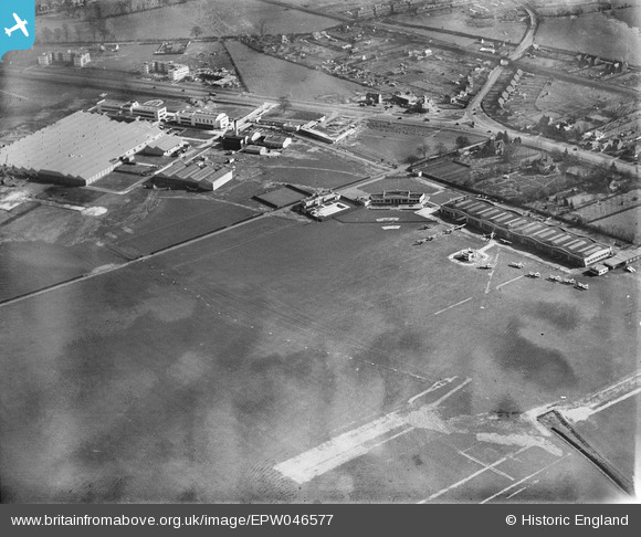
EPW046577 ENGLAND (1935). Hatfield Aerodrome, Hatfield, 1935
© Copyright OpenStreetMap contributors and licensed by the OpenStreetMap Foundation. 2026. Cartography is licensed as CC BY-SA.
Nearby Images (14)
Details
| Title | [EPW046577] Hatfield Aerodrome, Hatfield, 1935 |
| Reference | EPW046577 |
| Date | March-1935 |
| Link | |
| Place name | HATFIELD |
| Parish | HATFIELD |
| District | |
| Country | ENGLAND |
| Easting / Northing | 521387, 208770 |
| Longitude / Latitude | -0.24081485390997, 51.763983106528 |
| National Grid Reference | TL214088 |
Pins

Chells809 |
Monday 17th of June 2013 10:05:15 PM | |

Chells809 |
Monday 17th of June 2013 10:03:00 PM | |

Chells809 |
Monday 17th of June 2013 10:00:25 PM | |

Chells809 |
Monday 17th of June 2013 09:59:06 PM | |

Chells809 |
Monday 17th of June 2013 09:57:42 PM | |

DerekM |
Sunday 5th of May 2013 12:30:39 PM |
User Comment Contributions
I remember going to an Open Day at Hatfield areodrome in 1969. By that time De Havilland had become part of the Hawker Siddeley group and Trident jets were landing and taking off rather than biplanes! |

Chells809 |
Monday 17th of June 2013 10:07:54 PM |


![[EPW046577] Hatfield Aerodrome, Hatfield, 1935](http://britainfromabove.org.uk/sites/all/libraries/aerofilms-images/public/100x100/EPW/046/EPW046577.jpg)
![[EPW042826] Hatfield Aerodrome Swimming Pool, Hatfield, 1933](http://britainfromabove.org.uk/sites/all/libraries/aerofilms-images/public/100x100/EPW/042/EPW042826.jpg)
![[EPW042827] Hatfield Aerodrome Club House, Swimming Pool and hangars, Hatfield, 1933](http://britainfromabove.org.uk/sites/all/libraries/aerofilms-images/public/100x100/EPW/042/EPW042827.jpg)
![[EPW042829] Hatfield Aerodrome Club House and hangars, Hatfield, 1933](http://britainfromabove.org.uk/sites/all/libraries/aerofilms-images/public/100x100/EPW/042/EPW042829.jpg)
![[EPW046580] The Barnet Bypass and buildings at Hatfield Aerodrome, Hatfield, 1935](http://britainfromabove.org.uk/sites/all/libraries/aerofilms-images/public/100x100/EPW/046/EPW046580.jpg)
![[EPW042828] Hatfield Aerodrome Club House and hangars, Hatfield, 1933](http://britainfromabove.org.uk/sites/all/libraries/aerofilms-images/public/100x100/EPW/042/EPW042828.jpg)
![[EPW042825] Hatfield Aerodrome Club House and hangars, Hatfield, 1933](http://britainfromabove.org.uk/sites/all/libraries/aerofilms-images/public/100x100/EPW/042/EPW042825.jpg)
![[EPW047566] Hangars, the club house and De Havilland Works at Hatfield Aerodrome, Hatfield, 1935](http://britainfromabove.org.uk/sites/all/libraries/aerofilms-images/public/100x100/EPW/047/EPW047566.jpg)
![[EPW061123] Birchwood, Roe Green, Hatfield Aerodrome and environs, Hatfield, 1939](http://britainfromabove.org.uk/sites/all/libraries/aerofilms-images/public/100x100/EPW/061/EPW061123.jpg)
![[EPW061120] Hatfield Aerodrome, Hatfield, 1939](http://britainfromabove.org.uk/sites/all/libraries/aerofilms-images/public/100x100/EPW/061/EPW061120.jpg)
![[EPW047559] The De Havilland Works at Hatfield Aerodrome and environs, Hatfield, 1935](http://britainfromabove.org.uk/sites/all/libraries/aerofilms-images/public/100x100/EPW/047/EPW047559.jpg)
![[EPW047564] The De Havilland Works, hangars and club house at Hatfield Aerodrome, Hatfield, 1935](http://britainfromabove.org.uk/sites/all/libraries/aerofilms-images/public/100x100/EPW/047/EPW047564.jpg)
![[EPW047558] The De Havilland Works at Hatfield Aerodrome, Hatfield, 1935](http://britainfromabove.org.uk/sites/all/libraries/aerofilms-images/public/100x100/EPW/047/EPW047558.jpg)
![[EPW047560] The De Havilland Works at Hatfield Aerodrome, Hatfield, 1935](http://britainfromabove.org.uk/sites/all/libraries/aerofilms-images/public/100x100/EPW/047/EPW047560.jpg)