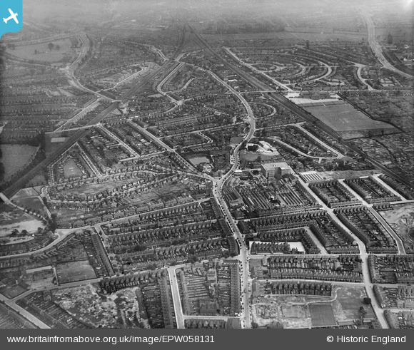
EPW058131 ENGLAND (1938). Alum Rock Road, Cotterills Lane and environs, Birmingham, from the west, 1938
© Copyright OpenStreetMap contributors and licensed by the OpenStreetMap Foundation. 2026. Cartography is licensed as CC BY-SA.
Nearby Images (9)
Details
| Title | [EPW058131] Alum Rock Road, Cotterills Lane and environs, Birmingham, from the west, 1938 |
| Reference | EPW058131 |
| Date | 19-July-1938 |
| Link | |
| Place name | BIRMINGHAM |
| Parish | |
| District | |
| Country | ENGLAND |
| Easting / Northing | 410871, 287827 |
| Longitude / Latitude | -1.8398855332073, 52.487882582991 |
| National Grid Reference | SP109878 |
Pins

Rich |
Thursday 16th of April 2020 02:05:36 PM | |

Griffin |
Sunday 15th of November 2015 04:20:53 PM | |

Griffin |
Sunday 15th of November 2015 04:19:34 PM | |

Griffin |
Sunday 15th of November 2015 04:12:01 PM | |

Griffin |
Sunday 15th of November 2015 03:58:01 PM | |

Griffin |
Sunday 15th of November 2015 03:42:53 PM | |

Mr Pastry |
Tuesday 10th of June 2014 01:40:18 PM | |
THE BUILDING IS STILL THERE BUT CLOSED AND BOARDED UP....HOW MUCH LONGER WILL IT SURVIVE? |

Griffin |
Sunday 15th of November 2015 03:45:35 PM |

Tinkerbell |
Sunday 8th of June 2014 04:33:50 PM | |

Tinkerbell |
Sunday 8th of June 2014 04:33:15 PM | |

Tinkerbell |
Saturday 7th of June 2014 03:03:23 PM | |
NOW CALLED 'SHAW HILL PRIMARY SCHOOL'. |

Griffin |
Sunday 15th of November 2015 03:51:33 PM |

Ron41 |
Tuesday 22nd of April 2014 08:38:38 PM | |

Ron41 |
Tuesday 22nd of April 2014 08:29:54 PM | |

Mick |
Monday 26th of August 2013 12:31:55 PM | |
NO LONGER A GRAMMAR SCHOOL.....MAPS SHOW 'SALTLEY ACADEMY' BUT BOARD OUTSIDE ENTRANCE, IN BELCHERS LANE, SHOWS 'SALTLEY SCHOOL AND SPECIALIST SCIENCE COLLEGE'. |

Griffin |
Sunday 15th of November 2015 04:07:00 PM |

Brasspot |
Friday 23rd of August 2013 05:39:15 PM | |

Brasspot |
Friday 23rd of August 2013 05:38:05 PM | |

Brasspot |
Friday 23rd of August 2013 05:34:52 PM |


![[EPW058131] Alum Rock Road, Cotterills Lane and environs, Birmingham, from the west, 1938](http://britainfromabove.org.uk/sites/all/libraries/aerofilms-images/public/100x100/EPW/058/EPW058131.jpg)
![[EPW035897] Housing surrounding Foxton Road, Watson Road and the Charford Surgical Dressing Mills, Saltley, 1931](http://britainfromabove.org.uk/sites/all/libraries/aerofilms-images/public/100x100/EPW/035/EPW035897.jpg)
![[EPW035896] Housing surrounding Foxton Road, Watson Road and the Charford Surgical Dressing Mills, Saltley, 1931](http://britainfromabove.org.uk/sites/all/libraries/aerofilms-images/public/100x100/EPW/035/EPW035896.jpg)
![[EPW035893] Housing surrounding Foxton Road, Watson Road and Tranter Road, Saltley, 1931. This image has been produced from a print.](http://britainfromabove.org.uk/sites/all/libraries/aerofilms-images/public/100x100/EPW/035/EPW035893.jpg)
![[EPW059813] Southalls Charford Mills and environs, Birmingham, 1938. This image has been produced from a print.](http://britainfromabove.org.uk/sites/all/libraries/aerofilms-images/public/100x100/EPW/059/EPW059813.jpg)
![[EPW059815] Southalls Charford Mills and environs, Birmingham, 1938. This image has been produced from a print.](http://britainfromabove.org.uk/sites/all/libraries/aerofilms-images/public/100x100/EPW/059/EPW059815.jpg)
![[EPW035892] Housing surrounding Foxton Road, Watson Road and Tranter Road, Saltley, 1931. This image has been produced from a print.](http://britainfromabove.org.uk/sites/all/libraries/aerofilms-images/public/100x100/EPW/035/EPW035892.jpg)
![[EPW035895] Housing surrounding Foxton Road, Watson Road and Sunnydene, Saltley, 1931](http://britainfromabove.org.uk/sites/all/libraries/aerofilms-images/public/100x100/EPW/035/EPW035895.jpg)
![[EPW035898] Housing surrounding Foxton Road, Watson Road and Brook Hill Road, Saltley, 1931](http://britainfromabove.org.uk/sites/all/libraries/aerofilms-images/public/100x100/EPW/035/EPW035898.jpg)