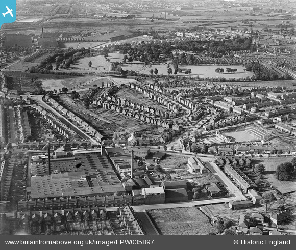
EPW035897 ENGLAND (1931). Housing surrounding Foxton Road, Watson Road and the Charford Surgical Dressing Mills, Saltley, 1931
    © Copyright OpenStreetMap contributors and licensed by the OpenStreetMap Foundation. 2025. Cartography is licensed as CC BY-SA.
  
Nearby Images (9)
Details
| Title | [EPW035897] Housing surrounding Foxton Road, Watson Road and the Charford Surgical Dressing Mills, Saltley, 1931 | 
| Reference | EPW035897 | 
| Date | July-1931 | 
| Link | |
| Place name | SALTLEY | 
| Parish | |
| District | |
| Country | ENGLAND | 
| Easting / Northing | 410992, 287905 | 
| Longitude / Latitude | -1.8381008069094, 52.488581452834 | 
| National Grid Reference | SP110879 | 
Pins
|  The Bromford PH |   frothy | Tuesday 23rd of September 2014 08:04:17 PM | 
|  Bromford Bridge |   frothy | Tuesday 23rd of September 2014 08:02:03 PM | 
|  Tyburn road bus repair works |   frothy | Tuesday 23rd of September 2014 08:00:20 PM | 
|  Valor Stoves |   frothy | Tuesday 23rd of September 2014 07:59:08 PM | 
|  Bromford Tubes |   frothy | Tuesday 23rd of September 2014 07:58:18 PM | 
|  Morris cars |   frothy | Tuesday 23rd of September 2014 07:57:10 PM | 
|  Fort Dunlop |   MWS | Friday 14th of December 2012 01:18:11 PM | 
|  Sladefield Road |   MWS | Thursday 13th of December 2012 12:45:55 PM | 
|  Drews Lane |   MWS | Thursday 13th of December 2012 12:44:10 PM | 
|  Ward End Park |   MWS | Thursday 13th of December 2012 12:43:24 PM | 
|  Foxton Road |   MWS | Thursday 13th of December 2012 12:42:51 PM | 
|  The Brookhill |   MWS | Thursday 13th of December 2012 12:42:10 PM | 
 
             
  ![[EPW035897] Housing surrounding Foxton Road, Watson Road and the Charford Surgical Dressing Mills, Saltley, 1931](http://britainfromabove.org.uk/sites/all/libraries/aerofilms-images/public/100x100/EPW/035/EPW035897.jpg) 
  
                                          ![[EPW035896] Housing surrounding Foxton Road, Watson Road and the Charford Surgical Dressing Mills, Saltley, 1931](http://britainfromabove.org.uk/sites/all/libraries/aerofilms-images/public/100x100/EPW/035/EPW035896.jpg) 
 ![[EPW035893] Housing surrounding Foxton Road, Watson Road and Tranter Road, Saltley, 1931. This image has been produced from a print.](http://britainfromabove.org.uk/sites/all/libraries/aerofilms-images/public/100x100/EPW/035/EPW035893.jpg) 
 ![[EPW058131] Alum Rock Road, Cotterills Lane and environs, Birmingham, from the west, 1938](http://britainfromabove.org.uk/sites/all/libraries/aerofilms-images/public/100x100/EPW/058/EPW058131.jpg) 
 ![[EPW035898] Housing surrounding Foxton Road, Watson Road and Brook Hill Road, Saltley, 1931](http://britainfromabove.org.uk/sites/all/libraries/aerofilms-images/public/100x100/EPW/035/EPW035898.jpg) 
 ![[EPW035895] Housing surrounding Foxton Road, Watson Road and Sunnydene, Saltley, 1931](http://britainfromabove.org.uk/sites/all/libraries/aerofilms-images/public/100x100/EPW/035/EPW035895.jpg) 
 ![[EPW035894] Housing surrounding Foxton Road, Watson Road and Sunnydene, Saltley, 1931](http://britainfromabove.org.uk/sites/all/libraries/aerofilms-images/public/100x100/EPW/035/EPW035894.jpg) 
 ![[EPW035892] Housing surrounding Foxton Road, Watson Road and Tranter Road, Saltley, 1931. This image has been produced from a print.](http://britainfromabove.org.uk/sites/all/libraries/aerofilms-images/public/100x100/EPW/035/EPW035892.jpg) 
 ![[EPW059813] Southalls Charford Mills and environs, Birmingham, 1938. This image has been produced from a print.](http://britainfromabove.org.uk/sites/all/libraries/aerofilms-images/public/100x100/EPW/059/EPW059813.jpg)