
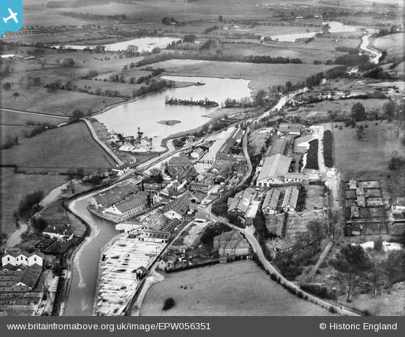
EPW056351 ENGLAND (1938). Harefield Mills on the Grand Union Canal, Harefield, 1938
© Copyright OpenStreetMap contributors and licensed by the OpenStreetMap Foundation. 2026. Cartography is licensed as CC BY-SA.
Nearby Images (24)
EPW056351

EPW056348

EPW056350

EPW056352

EPW056353

EPW006652

EPW057663

EPW006658

EPW006661

EPW056349

EPW057661

EPW006657

EPW057662

EPW056354

EPW006663

EPW056355

EPW006667

EPW006668

EPW006659

EPW006654

EPW006664

EPW006660

EPW006662

EPW006653

Details
| Title | [EPW056351] Harefield Mills on the Grand Union Canal, Harefield, 1938 |
| Reference | EPW056351 |
| Date | 5-February-1938 |
| Link | |
| Place name | HAREFIELD |
| Parish | |
| District | |
| Country | ENGLAND |
| Easting / Northing | 504092, 191239 |
| Longitude / Latitude | -0.4965894140453, 51.609878176043 |
| National Grid Reference | TQ041912 |
Pins

Davmar |
Sunday 1st of June 2014 02:30:23 PM | |
|
Davmar |
Sunday 1st of June 2014 02:28:48 PM | |
|
Davmar |
Sunday 1st of June 2014 02:27:02 PM | |
|
Davmar |
Sunday 1st of June 2014 02:24:55 PM | |
|
Davmar |
Sunday 1st of June 2014 02:23:39 PM | |
|
Davmar |
Sunday 1st of June 2014 01:42:58 PM | |
|
MB |
Saturday 6th of July 2013 09:59:37 PM |