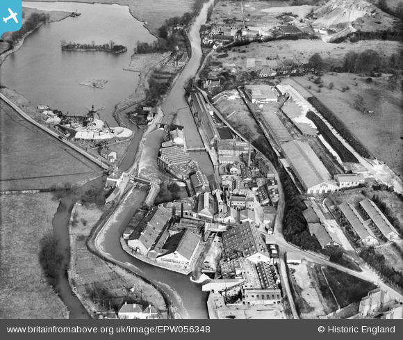
EPW056348 ENGLAND (1938). Harefield Mills on the Grand Union Canal, Harefield, 1938
© Copyright OpenStreetMap contributors and licensed by the OpenStreetMap Foundation. 2026. Cartography is licensed as CC BY-SA.
Nearby Images (26)
Details
| Title | [EPW056348] Harefield Mills on the Grand Union Canal, Harefield, 1938 |
| Reference | EPW056348 |
| Date | 5-February-1938 |
| Link | |
| Place name | HAREFIELD |
| Parish | |
| District | |
| Country | ENGLAND |
| Easting / Northing | 504101, 191196 |
| Longitude / Latitude | -0.49647224644632, 51.609489974392 |
| National Grid Reference | TQ041912 |
Pins
Be the first to add a comment to this image!


![[EPW056348] Harefield Mills on the Grand Union Canal, Harefield, 1938](http://britainfromabove.org.uk/sites/all/libraries/aerofilms-images/public/100x100/EPW/056/EPW056348.jpg)
![[EPW056350] Harefield Mills on the Grand Union Canal, Harefield, 1938](http://britainfromabove.org.uk/sites/all/libraries/aerofilms-images/public/100x100/EPW/056/EPW056350.jpg)
![[EPW056353] Harefield Mills on the Grand Union Canal, Harefield, 1938](http://britainfromabove.org.uk/sites/all/libraries/aerofilms-images/public/100x100/EPW/056/EPW056353.jpg)
![[EPW006658] Bells United Asbestos Works, Harefield, 1921](http://britainfromabove.org.uk/sites/all/libraries/aerofilms-images/public/100x100/EPW/006/EPW006658.jpg)
![[EPW056351] Harefield Mills on the Grand Union Canal, Harefield, 1938](http://britainfromabove.org.uk/sites/all/libraries/aerofilms-images/public/100x100/EPW/056/EPW056351.jpg)
![[EPW057663] The Bell Rubber Works, Harefield, 1938. This image has been produced from a damaged negative.](http://britainfromabove.org.uk/sites/all/libraries/aerofilms-images/public/100x100/EPW/057/EPW057663.jpg)
![[EPW056349] Harefield Mills on the Grand Union Canal, Harefield, 1938](http://britainfromabove.org.uk/sites/all/libraries/aerofilms-images/public/100x100/EPW/056/EPW056349.jpg)
![[EPW006657] Bells United Asbestos Works, Harefield, 1921](http://britainfromabove.org.uk/sites/all/libraries/aerofilms-images/public/100x100/EPW/006/EPW006657.jpg)
![[EPW057661] The Bell Rubber Works, Harefield, 1938. This image has been produced from a damaged negative.](http://britainfromabove.org.uk/sites/all/libraries/aerofilms-images/public/100x100/EPW/057/EPW057661.jpg)
![[EPW057662] The Bell Rubber Works, Harefield, 1938](http://britainfromabove.org.uk/sites/all/libraries/aerofilms-images/public/100x100/EPW/057/EPW057662.jpg)
![[EPW006652] View of Bells United Asbestos Works, Maple Cross, from the west, 1921](http://britainfromabove.org.uk/sites/all/libraries/aerofilms-images/public/100x100/EPW/006/EPW006652.jpg)
![[EPW056355] Harefield Mills on the Grand Union Canal, Harefield, 1938](http://britainfromabove.org.uk/sites/all/libraries/aerofilms-images/public/100x100/EPW/056/EPW056355.jpg)
![[EPW056352] Harefield Mills on the Grand Union Canal, Harefield, 1938](http://britainfromabove.org.uk/sites/all/libraries/aerofilms-images/public/100x100/EPW/056/EPW056352.jpg)
![[EPW006659] Bells United Asbestos Works, Harefield, 1921](http://britainfromabove.org.uk/sites/all/libraries/aerofilms-images/public/100x100/EPW/006/EPW006659.jpg)
![[EPW006663] Bells United Asbestos Works, Harefield, 1921](http://britainfromabove.org.uk/sites/all/libraries/aerofilms-images/public/100x100/EPW/006/EPW006663.jpg)
![[EPW006668] Bells United Asbestos Works, Harefield, 1921](http://britainfromabove.org.uk/sites/all/libraries/aerofilms-images/public/100x100/EPW/006/EPW006668.jpg)
![[EPW056354] Harefield Mills on the Grand Union Canal, Harefield, 1938](http://britainfromabove.org.uk/sites/all/libraries/aerofilms-images/public/100x100/EPW/056/EPW056354.jpg)
![[EPW006667] Bells United Asbestos Works, Harefield, 1921](http://britainfromabove.org.uk/sites/all/libraries/aerofilms-images/public/100x100/EPW/006/EPW006667.jpg)
![[EPW006661] Bells United Asbestos Works, Harefield, 1921](http://britainfromabove.org.uk/sites/all/libraries/aerofilms-images/public/100x100/EPW/006/EPW006661.jpg)
![[EPW006654] View of Bells United Asbestos Works, Maple Cross, from the west, 1921](http://britainfromabove.org.uk/sites/all/libraries/aerofilms-images/public/100x100/EPW/006/EPW006654.jpg)
![[EPW006664] Bells United Asbestos Works, Harefield, 1921](http://britainfromabove.org.uk/sites/all/libraries/aerofilms-images/public/100x100/EPW/006/EPW006664.jpg)
![[EPW006660] Bells United Asbestos Works, Harefield, 1921](http://britainfromabove.org.uk/sites/all/libraries/aerofilms-images/public/100x100/EPW/006/EPW006660.jpg)
![[EPW006662] View of Bells United Asbestos Works, Maple Cross, from the west, 1921](http://britainfromabove.org.uk/sites/all/libraries/aerofilms-images/public/100x100/EPW/006/EPW006662.jpg)
![[EPW006653] Bells United Asbestos Works, Harefield, 1921](http://britainfromabove.org.uk/sites/all/libraries/aerofilms-images/public/100x100/EPW/006/EPW006653.jpg)
![[EPW006656] View of Bells United Asbestos Works, Maple Cross, from the west, 1921](http://britainfromabove.org.uk/sites/all/libraries/aerofilms-images/public/100x100/EPW/006/EPW006656.jpg)
![[EPW056357] Harefield Mills on the Grand Union Canal and the site of the disused Harefield Mills, Harefield, 1938](http://britainfromabove.org.uk/sites/all/libraries/aerofilms-images/public/100x100/EPW/056/EPW056357.jpg)