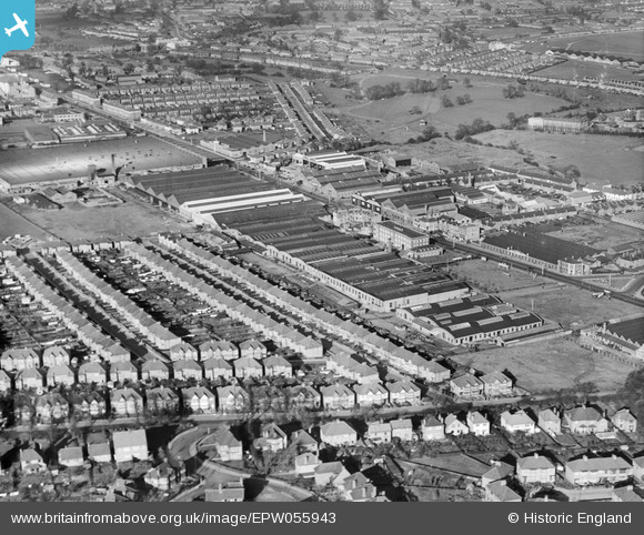
EPW055943 ENGLAND (1937). Works off the Edgware Road including the Phoenix Telephone and Electric Co Works, Kingsbury, 1937
© Copyright OpenStreetMap contributors and licensed by the OpenStreetMap Foundation. 2026. Cartography is licensed as CC BY-SA.
Nearby Images (39)
Details
| Title | [EPW055943] Works off the Edgware Road including the Phoenix Telephone and Electric Co Works, Kingsbury, 1937 |
| Reference | EPW055943 |
| Date | 9-November-1937 |
| Link | |
| Place name | KINGSBURY |
| Parish | |
| District | |
| Country | ENGLAND |
| Easting / Northing | 520720, 189528 |
| Longitude / Latitude | -0.25713007980505, 51.591179190524 |
| National Grid Reference | TQ207895 |
Pins

ken |
Wednesday 19th of August 2015 07:06:19 PM | |

Class31 |
Tuesday 28th of April 2015 08:49:39 AM | |

Mark Amies |
Tuesday 25th of February 2014 05:56:07 PM | |
Would love to see a photo of this building now, there are very few structures remaining that were contemporary with the aerodrome. Yours, Katy |
Katy Whitaker |
Tuesday 25th of February 2014 06:17:37 PM |
There is a short article on the web, see: Disused Stations: Hendon Factory Platform with photos. |

ken |
Wednesday 19th of August 2015 07:30:12 PM |
Here you go...Information and pictures... http://www.disused-stations.org.uk/h/hendon_factory_platform/index.shtml |

bernie |
Thursday 5th of November 2015 05:09:24 PM |

bernie |
Sunday 26th of January 2014 12:37:50 PM | |

bernie |
Sunday 26th of January 2014 12:31:30 PM | |

bernie |
Sunday 26th of January 2014 12:30:46 PM | |

bernie |
Sunday 26th of January 2014 12:29:09 PM | |

colsouth111 |
Tuesday 24th of December 2013 05:49:13 PM | |

colsouth111 |
Tuesday 24th of December 2013 05:48:24 PM | |

colsouth111 |
Tuesday 24th of December 2013 05:46:36 PM | |

colsouth111 |
Tuesday 24th of December 2013 05:46:08 PM | |

colsouth111 |
Wednesday 7th of August 2013 11:07:48 AM | |

colsouth111 |
Wednesday 7th of August 2013 10:55:59 AM | |

colsouth111 |
Wednesday 7th of August 2013 10:51:41 AM |
User Comment Contributions
The Aircraft Manufacturing Company, Edgware Road around 1916 |

Class31 |
Tuesday 28th of April 2015 08:47:53 AM |


![[EPW055943] Works off the Edgware Road including the Phoenix Telephone and Electric Co Works, Kingsbury, 1937](http://britainfromabove.org.uk/sites/all/libraries/aerofilms-images/public/100x100/EPW/055/EPW055943.jpg)
![[EPW055947] Works off the Edgware Road including the Phoenix Telephone and Electric Co Works, Kingsbury, 1937](http://britainfromabove.org.uk/sites/all/libraries/aerofilms-images/public/100x100/EPW/055/EPW055947.jpg)
![[EPW055949] The Phoenix Telephone and Electric Co Works and environs, Kingsbury, 1937](http://britainfromabove.org.uk/sites/all/libraries/aerofilms-images/public/100x100/EPW/055/EPW055949.jpg)
![[EPW055951] The Phoenix Telephone and Electric Co Works and environs, Kingsbury, 1937](http://britainfromabove.org.uk/sites/all/libraries/aerofilms-images/public/100x100/EPW/055/EPW055951.jpg)
![[EPW055944] The Phoenix Telephone and Electric Co Works, Kingsbury, 1937. This image was marked by Aerofilms Ltd for photo editing.](http://britainfromabove.org.uk/sites/all/libraries/aerofilms-images/public/100x100/EPW/055/EPW055944.jpg)
![[EPW055950] Works off the Edgware Road including the Phoenix Telephone and Electric Co Works, Kingsbury, 1937](http://britainfromabove.org.uk/sites/all/libraries/aerofilms-images/public/100x100/EPW/055/EPW055950.jpg)
![[EPW055946] The Phoenix Telephone and Electric Co Works and environs, Kingsbury, 1937](http://britainfromabove.org.uk/sites/all/libraries/aerofilms-images/public/100x100/EPW/055/EPW055946.jpg)
![[EPW013752] Factories and school building (former AIRCO offices) on the Hyde (Edgware Road), Kingsbury, 1928. This image has been produced from a print.](http://britainfromabove.org.uk/sites/all/libraries/aerofilms-images/public/100x100/EPW/013/EPW013752.jpg)
![[EPW055952] Works off the Edgware Road including the Phoenix Telephone and Electric Co Works and Davies Tyres Works, Kingsbury, 1937](http://britainfromabove.org.uk/sites/all/libraries/aerofilms-images/public/100x100/EPW/055/EPW055952.jpg)
![[EPW055948] The Daimler Co Repair and Hiring Depot and the Phoenix Telephone and Electric Co Works, Queensbury, 1937](http://britainfromabove.org.uk/sites/all/libraries/aerofilms-images/public/100x100/EPW/055/EPW055948.jpg)
![[EPW012748] Factories on the Edgware Road, Colindale, 1925](http://britainfromabove.org.uk/sites/all/libraries/aerofilms-images/public/100x100/EPW/012/EPW012748.jpg)
![[EPW055945] The Daimler Co Repair and Hiring Depot and surrounding works on Edgware Road, Queensbury, 1937](http://britainfromabove.org.uk/sites/all/libraries/aerofilms-images/public/100x100/EPW/055/EPW055945.jpg)
![[EPW024932] The Safetex Glass Works, Colindale, 1928](http://britainfromabove.org.uk/sites/all/libraries/aerofilms-images/public/100x100/EPW/024/EPW024932.jpg)
![[EPW024761] Factories along the Edgware Road near Colindale Hospital, Colindale, 1928. This image has been produced from a print marked by Aerofilms Ltd for photo editing.](http://britainfromabove.org.uk/sites/all/libraries/aerofilms-images/public/100x100/EPW/024/EPW024761.jpg)
![[EPW024931] Aerofilms Ltd on Colindale Avenue, Colindale, 1928](http://britainfromabove.org.uk/sites/all/libraries/aerofilms-images/public/100x100/EPW/024/EPW024931.jpg)
![[EPW034540] Aerofilms Ltd on Colindale Avenue, Colindale, 1930](http://britainfromabove.org.uk/sites/all/libraries/aerofilms-images/public/100x100/EPW/034/EPW034540.jpg)
![[EPW020844] Aerofilms Ltd offices on Colindale Avenue, Hendon, 1928](http://britainfromabove.org.uk/sites/all/libraries/aerofilms-images/public/100x100/EPW/020/EPW020844.jpg)
![[EPW032159] Davies Tyre Works and environs, Colindale, 1930](http://britainfromabove.org.uk/sites/all/libraries/aerofilms-images/public/100x100/EPW/032/EPW032159.jpg)
![[EPW032158] Davies Tyre Works and Edgware Road, Colindale, 1930](http://britainfromabove.org.uk/sites/all/libraries/aerofilms-images/public/100x100/EPW/032/EPW032158.jpg)
![[EPW020810] Desoutter Brothers Ltd Electrical Tool Works, Colindale, 1928](http://britainfromabove.org.uk/sites/all/libraries/aerofilms-images/public/100x100/EPW/020/EPW020810.jpg)
![[EPW015610] Motor Works, hospital and Hendon Aerodrome, Colindale, 1926](http://britainfromabove.org.uk/sites/all/libraries/aerofilms-images/public/100x100/EPW/015/EPW015610.jpg)
![[EPW021145] Desoutter Brothers Electrical Tool Works, The Hyde, 1928](http://britainfromabove.org.uk/sites/all/libraries/aerofilms-images/public/100x100/EPW/021/EPW021145.jpg)
![[EPW021147] Desoutter Brothers Electrical Tool Works, The Hyde, 1928](http://britainfromabove.org.uk/sites/all/libraries/aerofilms-images/public/100x100/EPW/021/EPW021147.jpg)
![[EPW021144] Desoutter Brothers Electrical Tool Works and Beardmore Motor Works, The Hyde, 1928](http://britainfromabove.org.uk/sites/all/libraries/aerofilms-images/public/100x100/EPW/021/EPW021144.jpg)
![[EPW020686] Desoutter Brothers Ltd and the Beardmore Motor Works, The Hyde, 1928](http://britainfromabove.org.uk/sites/all/libraries/aerofilms-images/public/100x100/EPW/020/EPW020686.jpg)
![[EPW020689] Desoutter Brothers Ltd, The Hyde, 1928](http://britainfromabove.org.uk/sites/all/libraries/aerofilms-images/public/100x100/EPW/020/EPW020689.jpg)
![[EPW020812] Desoutter Brothers Ltd Electrical Tool Works, Colindale, 1928](http://britainfromabove.org.uk/sites/all/libraries/aerofilms-images/public/100x100/EPW/020/EPW020812.jpg)
![[EPW021146] Desoutter Brothers Electrical Tool Works and Beardmore Motor Works, The Hyde, 1928](http://britainfromabove.org.uk/sites/all/libraries/aerofilms-images/public/100x100/EPW/021/EPW021146.jpg)
![[EPR000505] The Desoutter Bros Ltd Electrical Tool Works, The Hyde, 1935. This image was marked by Aero Pictorial Ltd for photo editing.](http://britainfromabove.org.uk/sites/all/libraries/aerofilms-images/public/100x100/EPR/000/EPR000505.jpg)
![[EPW020683] Desoutter Brothers Ltd, The Hyde, 1928](http://britainfromabove.org.uk/sites/all/libraries/aerofilms-images/public/100x100/EPW/020/EPW020683.jpg)
![[EPW020811] Desoutter Brothers Ltd Electrical Tool Works, Colindale, 1928](http://britainfromabove.org.uk/sites/all/libraries/aerofilms-images/public/100x100/EPW/020/EPW020811.jpg)
![[EPW013751] Desoutter Brothers Ltd Electrical Tool Works, Kingsbury, 1928. This image has been produced from a print.](http://britainfromabove.org.uk/sites/all/libraries/aerofilms-images/public/100x100/EPW/013/EPW013751.jpg)
![[EPW020688] Desoutter Brothers Ltd and the Beardmore Motor Works, The Hyde, 1928](http://britainfromabove.org.uk/sites/all/libraries/aerofilms-images/public/100x100/EPW/020/EPW020688.jpg)
![[EPW020685] Desoutter Brothers Ltd and the Beardmore Motor Works, The Hyde, 1928](http://britainfromabove.org.uk/sites/all/libraries/aerofilms-images/public/100x100/EPW/020/EPW020685.jpg)
![[EPW020690] Desoutter Brothers Ltd and the Beardmore Motor Works, The Hyde, 1928](http://britainfromabove.org.uk/sites/all/libraries/aerofilms-images/public/100x100/EPW/020/EPW020690.jpg)
![[EPW020687] Desoutter Brothers Ltd and the Beardmore Motor Works, The Hyde, 1928](http://britainfromabove.org.uk/sites/all/libraries/aerofilms-images/public/100x100/EPW/020/EPW020687.jpg)
![[EPW020684] Desoutter Brothers Ltd, The Hyde, 1928](http://britainfromabove.org.uk/sites/all/libraries/aerofilms-images/public/100x100/EPW/020/EPW020684.jpg)
![[EAW013878] The Frigidaire Ltd Refrigerator Works and environs, Kingsbury, 1948. This image has been produced from a print.](http://britainfromabove.org.uk/sites/all/libraries/aerofilms-images/public/100x100/EAW/013/EAW013878.jpg)
![[EAW013884] The Frigidaire Ltd Refrigerator Works and environs, Kingsbury, 1948. This image has been produced from a print marked by Aerofilms Ltd for photo editing.](http://britainfromabove.org.uk/sites/all/libraries/aerofilms-images/public/100x100/EAW/013/EAW013884.jpg)