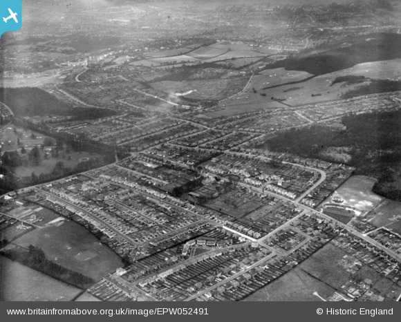
EPW052491 ENGLAND (1937). Housing around Foxearth Road, Sundale Avenue and environs, Selsdon, 1937. This image has been produced from a print.
© Copyright OpenStreetMap contributors and licensed by the OpenStreetMap Foundation. 2026. Cartography is licensed as CC BY-SA.
Nearby Images (23)
Details
| Title | [EPW052491] Housing around Foxearth Road, Sundale Avenue and environs, Selsdon, 1937. This image has been produced from a print. |
| Reference | EPW052491 |
| Date | 22-March-1937 |
| Link | |
| Place name | SELSDON |
| Parish | |
| District | |
| Country | ENGLAND |
| Easting / Northing | 535044, 162403 |
| Longitude / Latitude | -0.060817179750297, 51.344144936717 |
| National Grid Reference | TQ350624 |
Pins
Be the first to add a comment to this image!


![[EPW052491] Housing around Foxearth Road, Sundale Avenue and environs, Selsdon, 1937. This image has been produced from a print.](http://britainfromabove.org.uk/sites/all/libraries/aerofilms-images/public/100x100/EPW/052/EPW052491.jpg)
![[EPW052492] Housing around Addington Road and environs, Selsdon, 1937. This image has been produced from a print.](http://britainfromabove.org.uk/sites/all/libraries/aerofilms-images/public/100x100/EPW/052/EPW052492.jpg)
![[EPW026623] Croham Hurst Golf Course and a new housing estate at Selsdon, Sanderstead, from the south-east, 1929](http://britainfromabove.org.uk/sites/all/libraries/aerofilms-images/public/100x100/EPW/026/EPW026623.jpg)
![[EPW015883] New housing at Farley Road, Selsdon, 1926](http://britainfromabove.org.uk/sites/all/libraries/aerofilms-images/public/100x100/EPW/015/EPW015883.jpg)
![[EPW015884] New housing at Farley Road, Selsdon, 1926](http://britainfromabove.org.uk/sites/all/libraries/aerofilms-images/public/100x100/EPW/015/EPW015884.jpg)
![[EPW015891] New housing at Farley Road, Selsdon, 1926. This image has been produced from a print.](http://britainfromabove.org.uk/sites/all/libraries/aerofilms-images/public/100x100/EPW/015/EPW015891.jpg)
![[EPW026625] Croham Hurst Golf Course and a new housing estate at Selsdon, Sanderstead, from the south-east, 1929](http://britainfromabove.org.uk/sites/all/libraries/aerofilms-images/public/100x100/EPW/026/EPW026625.jpg)
![[EPW052481] Housing around Addington Road, Farley Road and environs, Selsdon, 1937. This image has been produced from a print.](http://britainfromabove.org.uk/sites/all/libraries/aerofilms-images/public/100x100/EPW/052/EPW052481.jpg)
![[EPW052499] Housing around Sundale Avenue, Addington Road and environs, Selsdon, 1937. This image has been produced from a print.](http://britainfromabove.org.uk/sites/all/libraries/aerofilms-images/public/100x100/EPW/052/EPW052499.jpg)
![[EPW052480] Gee Wood, Foxearth Road and surrounding housing, Selsdon, 1937. This image has been produced from a print.](http://britainfromabove.org.uk/sites/all/libraries/aerofilms-images/public/100x100/EPW/052/EPW052480.jpg)
![[EPW052493] Housing around Farley Road, Croham Hurst Golf Course and environs, Selsdon, 1937. This image has been produced from a print.](http://britainfromabove.org.uk/sites/all/libraries/aerofilms-images/public/100x100/EPW/052/EPW052493.jpg)
![[EPW015887] New housing at Farley Road, Selsdon, 1926](http://britainfromabove.org.uk/sites/all/libraries/aerofilms-images/public/100x100/EPW/015/EPW015887.jpg)
![[EPW026622] Croham Hurst Golf Course and a new housing estate at Selsdon, Sanderstead, 1929](http://britainfromabove.org.uk/sites/all/libraries/aerofilms-images/public/100x100/EPW/026/EPW026622.jpg)
![[EPW026617] Croham Hurst Golf Course and a new housing estate at Selsdon, Sanderstead, from the south-east, 1929](http://britainfromabove.org.uk/sites/all/libraries/aerofilms-images/public/100x100/EPW/026/EPW026617.jpg)
![[EPW026616] A new housing estate at Selsdon, Sanderstead, 1929](http://britainfromabove.org.uk/sites/all/libraries/aerofilms-images/public/100x100/EPW/026/EPW026616.jpg)
![[EPW015880] New housing at Farley Road, Selsdon, 1926](http://britainfromabove.org.uk/sites/all/libraries/aerofilms-images/public/100x100/EPW/015/EPW015880.jpg)
![[EPW015876] New housing along Farley Road and view over Croham Hurst Golf Course, Selsdon, from the south-east, 1926](http://britainfromabove.org.uk/sites/all/libraries/aerofilms-images/public/100x100/EPW/015/EPW015876.jpg)
![[EPW015886] New housing at Farley Road, Selsdon, 1926](http://britainfromabove.org.uk/sites/all/libraries/aerofilms-images/public/100x100/EPW/015/EPW015886.jpg)
![[EPW052482] Housing around Foxearth Road and Farley Road, Croham Hurst Golf Course and environs, Selsdon, 1937. This image has been produced from a print.](http://britainfromabove.org.uk/sites/all/libraries/aerofilms-images/public/100x100/EPW/052/EPW052482.jpg)
![[EPW052500] Selsdon Park Hotel, Gee Wood and surrounding houses, Selsdon, 1937. This image has been produced from a print.](http://britainfromabove.org.uk/sites/all/libraries/aerofilms-images/public/100x100/EPW/052/EPW052500.jpg)
![[EPW026619] Croham Hurst Golf Course and a new housing estate at Selsdon, Sanderstead, 1929](http://britainfromabove.org.uk/sites/all/libraries/aerofilms-images/public/100x100/EPW/026/EPW026619.jpg)
![[EPW052497] Housing around Sundale Avenue and environs, Selsdon, 1937. This image has been produced from a print.](http://britainfromabove.org.uk/sites/all/libraries/aerofilms-images/public/100x100/EPW/052/EPW052497.jpg)
![[EPW015881] New housing at Farley Road, Selsdon, 1926](http://britainfromabove.org.uk/sites/all/libraries/aerofilms-images/public/100x100/EPW/015/EPW015881.jpg)