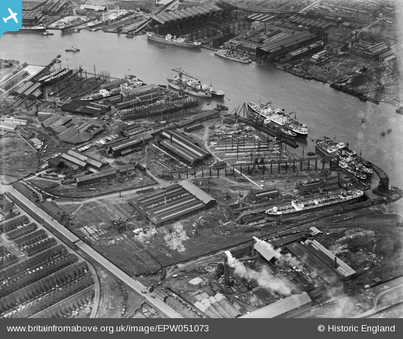
EPW051073 ENGLAND (1936). The Palmers Hebburn Co Shipbuilding Yard, Hebburn, 1936
© Copyright OpenStreetMap contributors and licensed by the OpenStreetMap Foundation. 2026. Cartography is licensed as CC BY-SA.
Nearby Images (11)
Details
| Title | [EPW051073] The Palmers Hebburn Co Shipbuilding Yard, Hebburn, 1936 |
| Reference | EPW051073 |
| Date | July-1936 |
| Link | |
| Place name | HEBBURN |
| Parish | |
| District | |
| Country | ENGLAND |
| Easting / Northing | 430831, 565559 |
| Longitude / Latitude | -1.5181766035774, 54.983600236253 |
| National Grid Reference | NZ308656 |
Pins

N Dunn |
Thursday 20th of October 2016 03:55:03 PM | |

N Dunn |
Thursday 20th of October 2016 03:53:45 PM | |

N Dunn |
Thursday 20th of October 2016 03:52:41 PM | |

N Dunn |
Thursday 20th of October 2016 03:51:56 PM | |

N Dunn |
Thursday 20th of October 2016 03:51:05 PM | |

N Dunn |
Tuesday 22nd of April 2014 09:56:52 AM | |

N Dunn |
Tuesday 22nd of April 2014 09:54:40 AM | |

N Dunn |
Tuesday 22nd of April 2014 09:53:30 AM | |

N Dunn |
Tuesday 22nd of April 2014 09:52:52 AM | |

N Dunn |
Tuesday 22nd of April 2014 09:51:58 AM | |

N Dunn |
Tuesday 22nd of April 2014 09:51:27 AM | |

N Dunn |
Tuesday 22nd of April 2014 09:49:09 AM | |

N Dunn |
Tuesday 22nd of April 2014 09:45:18 AM | |

N Dunn |
Tuesday 22nd of April 2014 09:44:34 AM | |

N Dunn |
Tuesday 22nd of April 2014 09:43:27 AM |


![[EPW051073] The Palmers Hebburn Co Shipbuilding Yard, Hebburn, 1936](http://britainfromabove.org.uk/sites/all/libraries/aerofilms-images/public/100x100/EPW/051/EPW051073.jpg)
![[EPW051070] The Palmers Hebburn Co Shipbuilding Yard, Hebburn, 1936](http://britainfromabove.org.uk/sites/all/libraries/aerofilms-images/public/100x100/EPW/051/EPW051070.jpg)
![[EPW051072] The Palmers Hebburn Co Shipbuilding Yard, Hebburn, 1936](http://britainfromabove.org.uk/sites/all/libraries/aerofilms-images/public/100x100/EPW/051/EPW051072.jpg)
![[EPW051075] The Palmers Hebburn Co Shipbuilding Yard, Hebburn, 1936](http://britainfromabove.org.uk/sites/all/libraries/aerofilms-images/public/100x100/EPW/051/EPW051075.jpg)
![[EPW051071] The Palmers Hebburn Co Shipbuilding Yard, Hebburn, 1936](http://britainfromabove.org.uk/sites/all/libraries/aerofilms-images/public/100x100/EPW/051/EPW051071.jpg)
![[EPW051074] The Palmers Hebburn Co Shipbuilding Yard, Hebburn, 1936](http://britainfromabove.org.uk/sites/all/libraries/aerofilms-images/public/100x100/EPW/051/EPW051074.jpg)
![[EPW051076] The Palmers Hebburn Co Shipbuilding Yard, Hebburn, 1936](http://britainfromabove.org.uk/sites/all/libraries/aerofilms-images/public/100x100/EPW/051/EPW051076.jpg)
![[EPW048226] The industrial area alongside the River Tyne, Hebburn, 1935](http://britainfromabove.org.uk/sites/all/libraries/aerofilms-images/public/100x100/EPW/048/EPW048226.jpg)
![[EAW002155] Shipbuilding Yards on the River Tyne, Hebburn, 1946](http://britainfromabove.org.uk/sites/all/libraries/aerofilms-images/public/100x100/EAW/002/EAW002155.jpg)
![[EPW048224] The industrial area alongside the River Tyne, Hebburn, 1935](http://britainfromabove.org.uk/sites/all/libraries/aerofilms-images/public/100x100/EPW/048/EPW048224.jpg)
![[EPW050751] Boats moored alongside the Palmers Hebburn Co Shipbuilding Yard, Hebburn, from the north-west, 1936](http://britainfromabove.org.uk/sites/all/libraries/aerofilms-images/public/100x100/EPW/050/EPW050751.jpg)