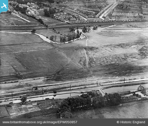
EPW050857 ENGLAND (1936). The site of the southern end of the William Girling Reservoir showing preliminary construction works, Edmonton, 1936
© Copyright OpenStreetMap contributors and licensed by the OpenStreetMap Foundation. 2026. Cartography is licensed as CC BY-SA.
Nearby Images (38)
Details
| Title | [EPW050857] The site of the southern end of the William Girling Reservoir showing preliminary construction works, Edmonton, 1936 |
| Reference | EPW050857 |
| Date | July-1936 |
| Link | |
| Place name | EDMONTON |
| Parish | |
| District | |
| Country | ENGLAND |
| Easting / Northing | 536493, 193663 |
| Longitude / Latitude | -0.027937345073119, 51.624739650153 |
| National Grid Reference | TQ365937 |
Pins

Neil H |
Tuesday 7th of May 2013 01:43:24 PM |
User Comment Contributions
This photo is taken from the west side of the William Girling Reservoir looking east. Priory Avenue and Cherrydown Avenue are noticeable. Waltham Way runs right to left going north but its progress at the time is halted only 6 to 8 houses north of Priory Avenue. |

Neil H |
Tuesday 7th of May 2013 01:59:14 PM |


![[EPW050857] The site of the southern end of the William Girling Reservoir showing preliminary construction works, Edmonton, 1936](http://britainfromabove.org.uk/sites/all/libraries/aerofilms-images/public/100x100/EPW/050/EPW050857.jpg)
![[EPW058472] The Chingford (William Girling) Reservoir under construction, Edmonton, 1938](http://britainfromabove.org.uk/sites/all/libraries/aerofilms-images/public/100x100/EPW/058/EPW058472.jpg)
![[EPW055969] The William Girling Reservoir under construction, Lower Edmonton, 1937](http://britainfromabove.org.uk/sites/all/libraries/aerofilms-images/public/100x100/EPW/055/EPW055969.jpg)
![[EAW040924] The recently completed William Girling Reservoir beginning to fill up with water, Edmonton, 1951](http://britainfromabove.org.uk/sites/all/libraries/aerofilms-images/public/100x100/EAW/040/EAW040924.jpg)
![[EPW056322] The William Girling Reservoir under construction, Edmonton, 1938](http://britainfromabove.org.uk/sites/all/libraries/aerofilms-images/public/100x100/EPW/056/EPW056322.jpg)
![[EPW056318] The William Girling Reservoir under construction, Edmonton, 1938](http://britainfromabove.org.uk/sites/all/libraries/aerofilms-images/public/100x100/EPW/056/EPW056318.jpg)
![[EAW044486] The William Girling Reservoir, Ponders End, 1952](http://britainfromabove.org.uk/sites/all/libraries/aerofilms-images/public/100x100/EAW/044/EAW044486.jpg)
![[EPW055974] The William Girling Reservoir under construction, Lower Edmonton, 1937](http://britainfromabove.org.uk/sites/all/libraries/aerofilms-images/public/100x100/EPW/055/EPW055974.jpg)
![[EPW060628] The William Girling Reservoir under construction, Lower Edmonton, 1939](http://britainfromabove.org.uk/sites/all/libraries/aerofilms-images/public/100x100/EPW/060/EPW060628.jpg)
![[EPW060636] The William Girling Reservoir under construction, Lower Edmonton, 1939](http://britainfromabove.org.uk/sites/all/libraries/aerofilms-images/public/100x100/EPW/060/EPW060636.jpg)
![[EAW044489] The William Girling Reservoir, Ponders End, 1952](http://britainfromabove.org.uk/sites/all/libraries/aerofilms-images/public/100x100/EAW/044/EAW044489.jpg)
![[EPW053844] The Chingford (William Girling) Reservoir under construction, Edmonton, 1937](http://britainfromabove.org.uk/sites/all/libraries/aerofilms-images/public/100x100/EPW/053/EPW053844.jpg)
![[EPW052286] The site of the William Girling Reservoir showing preliminary construction works, Edmonton, 1936](http://britainfromabove.org.uk/sites/all/libraries/aerofilms-images/public/100x100/EPW/052/EPW052286.jpg)
![[EPW048912] The site of the William Girling Reservoir, Lower Edmonton, 1935. This image has been produced from a damaged negative.](http://britainfromabove.org.uk/sites/all/libraries/aerofilms-images/public/100x100/EPW/048/EPW048912.jpg)
![[EPW052279] The site of the William Girling Reservoir showing preliminary construction works, Edmonton, 1936. This image has been produced from a damaged negative.](http://britainfromabove.org.uk/sites/all/libraries/aerofilms-images/public/100x100/EPW/052/EPW052279.jpg)
![[EPW056812] The William Girling Reservoir under construction, Edmonton, 1938](http://britainfromabove.org.uk/sites/all/libraries/aerofilms-images/public/100x100/EPW/056/EPW056812.jpg)
![[EPW050865] The site of the William Girling Reservoir showing preliminary construction works, Edmonton, 1936](http://britainfromabove.org.uk/sites/all/libraries/aerofilms-images/public/100x100/EPW/050/EPW050865.jpg)
![[EAW040927] The recently completed William Girling Reservoir beginning to fill up with water, Edmonton, 1951](http://britainfromabove.org.uk/sites/all/libraries/aerofilms-images/public/100x100/EAW/040/EAW040927.jpg)
![[EPW060643] The William Girling Reservoir under construction, King George's Reservoir and environs, Enfield, 1939](http://britainfromabove.org.uk/sites/all/libraries/aerofilms-images/public/100x100/EPW/060/EPW060643.jpg)
![[EPW053847] The Chingford (William Girling) Reservoir under construction, Edmonton, 1937](http://britainfromabove.org.uk/sites/all/libraries/aerofilms-images/public/100x100/EPW/053/EPW053847.jpg)
![[EPW056824] The William Girling Reservoir under construction, Edmonton, 1938](http://britainfromabove.org.uk/sites/all/libraries/aerofilms-images/public/100x100/EPW/056/EPW056824.jpg)
![[EPW060642] The William Girling Reservoir under construction and environs, Enfield, 1939](http://britainfromabove.org.uk/sites/all/libraries/aerofilms-images/public/100x100/EPW/060/EPW060642.jpg)
![[EPW060641] The William Girling Reservoir under construction and environs, Enfield, 1939](http://britainfromabove.org.uk/sites/all/libraries/aerofilms-images/public/100x100/EPW/060/EPW060641.jpg)
![[EPW058458] The Chingford (William Girling) Reservoir under construction, Edmonton, 1938](http://britainfromabove.org.uk/sites/all/libraries/aerofilms-images/public/100x100/EPW/058/EPW058458.jpg)
![[EPW060633] The William Girling Reservoir under construction, Enfield, 1939](http://britainfromabove.org.uk/sites/all/libraries/aerofilms-images/public/100x100/EPW/060/EPW060633.jpg)
![[EPW055973] The William Girling Reservoir under construction, Lower Edmonton, 1937](http://britainfromabove.org.uk/sites/all/libraries/aerofilms-images/public/100x100/EPW/055/EPW055973.jpg)
![[EPW056323] The William Girling Reservoir under construction, Edmonton, 1938](http://britainfromabove.org.uk/sites/all/libraries/aerofilms-images/public/100x100/EPW/056/EPW056323.jpg)
![[EPW060640] The William Girling Reservoir under construction, King George's Reservoir and environs, Enfield, 1939](http://britainfromabove.org.uk/sites/all/libraries/aerofilms-images/public/100x100/EPW/060/EPW060640.jpg)
![[EPW055972] The William Girling Reservoir under construction, Lower Edmonton, 1937](http://britainfromabove.org.uk/sites/all/libraries/aerofilms-images/public/100x100/EPW/055/EPW055972.jpg)
![[EPW056324] The William Girling Reservoir under construction, Edmonton, 1938](http://britainfromabove.org.uk/sites/all/libraries/aerofilms-images/public/100x100/EPW/056/EPW056324.jpg)
![[EPW056828] The William Girling Reservoir under construction, Edmonton, 1938](http://britainfromabove.org.uk/sites/all/libraries/aerofilms-images/public/100x100/EPW/056/EPW056828.jpg)
![[EPW055970] The William Girling Reservoir under construction, Lower Edmonton, 1937](http://britainfromabove.org.uk/sites/all/libraries/aerofilms-images/public/100x100/EPW/055/EPW055970.jpg)
![[EPW058463] The Chingford (William Girling) Reservoir under construction, Edmonton, from the south, 1938](http://britainfromabove.org.uk/sites/all/libraries/aerofilms-images/public/100x100/EPW/058/EPW058463.jpg)
![[EPW055984] The William Girling Reservoir under construction at Pickett's Lock, Enfield, 1937](http://britainfromabove.org.uk/sites/all/libraries/aerofilms-images/public/100x100/EPW/055/EPW055984.jpg)
![[EPW055977] The northern section of the William Girling Reservoir under construction, Enfield, 1937](http://britainfromabove.org.uk/sites/all/libraries/aerofilms-images/public/100x100/EPW/055/EPW055977.jpg)
![[EPW053848] The Chingford (William Girling) Reservoir under construction, Edmonton, 1937](http://britainfromabove.org.uk/sites/all/libraries/aerofilms-images/public/100x100/EPW/053/EPW053848.jpg)
![[EPW055985] The William Girling Reservoir under construction, Enfield, 1937](http://britainfromabove.org.uk/sites/all/libraries/aerofilms-images/public/100x100/EPW/055/EPW055985.jpg)
![[EPW058459] The Chingford (William Girling) Reservoir under construction, Edmonton, 1938](http://britainfromabove.org.uk/sites/all/libraries/aerofilms-images/public/100x100/EPW/058/EPW058459.jpg)