
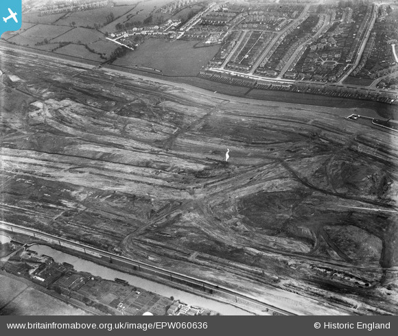
EPW060636 ENGLAND (1939). The William Girling Reservoir under construction, Lower Edmonton, 1939
© Copyright OpenStreetMap contributors and licensed by the OpenStreetMap Foundation. 2026. Cartography is licensed as CC BY-SA.
Nearby Images (38)
EPW060636

EPW052286

EPW048912

EPW052279

EPW056318

EPW055974

EAW040924

EAW044489

EPW055969

EPW056824

EPW056812

EPW060628

EPW058458
 Reservoir under construction, Edmonton, 1938")
EPW050857

EPW056322

EPW053844
 Reservoir under construction, Edmonton, 1937")
EPW058472
 Reservoir under construction, Edmonton, 1938")
EAW040927

EAW044486

EPW055970

EPW060642

EPW055973

EPW056323

EPW060633

EPW055972

EPW060641

EPW053847
 Reservoir under construction, Edmonton, 1937")
EPW056324

EPW050865

EPW060643

EPW058463
 Reservoir under construction, Edmonton, from the south, 1938")
EPW056828

EPW052281

EPW055984

EPW056317

EPW060640

EPW056327

EPW055983

Details
| Title | [EPW060636] The William Girling Reservoir under construction, Lower Edmonton, 1939 |
| Reference | EPW060636 |
| Date | 2-March-1939 |
| Link | |
| Place name | LOWER EDMONTON |
| Parish | |
| District | |
| Country | ENGLAND |
| Easting / Northing | 536562, 193612 |
| Longitude / Latitude | -0.026960951121738, 51.624264571041 |
| National Grid Reference | TQ366936 |
Pins
Be the first to add a comment to this image!