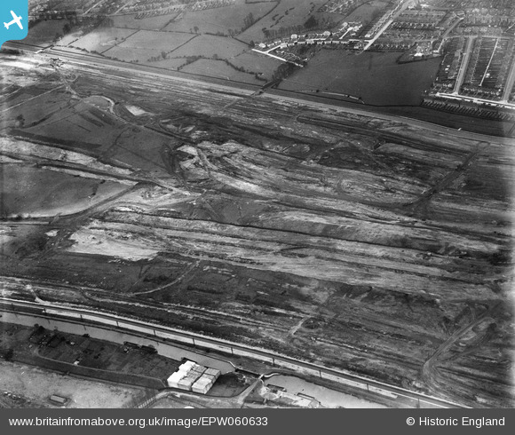
EPW060633 ENGLAND (1939). The William Girling Reservoir under construction, Enfield, 1939
© Copyright OpenStreetMap contributors and licensed by the OpenStreetMap Foundation. 2026. Cartography is licensed as CC BY-SA.
Nearby Images (36)
Details
| Title | [EPW060633] The William Girling Reservoir under construction, Enfield, 1939 |
| Reference | EPW060633 |
| Date | 2-March-1939 |
| Link | |
| Place name | ENFIELD |
| Parish | |
| District | |
| Country | ENGLAND |
| Easting / Northing | 536614, 193768 |
| Longitude / Latitude | -0.026149281151296, 51.625653915639 |
| National Grid Reference | TQ366938 |
Pins
Be the first to add a comment to this image!


![[EPW060633] The William Girling Reservoir under construction, Enfield, 1939](http://britainfromabove.org.uk/sites/all/libraries/aerofilms-images/public/100x100/EPW/060/EPW060633.jpg)
![[EPW060642] The William Girling Reservoir under construction and environs, Enfield, 1939](http://britainfromabove.org.uk/sites/all/libraries/aerofilms-images/public/100x100/EPW/060/EPW060642.jpg)
![[EPW060641] The William Girling Reservoir under construction and environs, Enfield, 1939](http://britainfromabove.org.uk/sites/all/libraries/aerofilms-images/public/100x100/EPW/060/EPW060641.jpg)
![[EPW056828] The William Girling Reservoir under construction, Edmonton, 1938](http://britainfromabove.org.uk/sites/all/libraries/aerofilms-images/public/100x100/EPW/056/EPW056828.jpg)
![[EPW053844] The Chingford (William Girling) Reservoir under construction, Edmonton, 1937](http://britainfromabove.org.uk/sites/all/libraries/aerofilms-images/public/100x100/EPW/053/EPW053844.jpg)
![[EPW060628] The William Girling Reservoir under construction, Lower Edmonton, 1939](http://britainfromabove.org.uk/sites/all/libraries/aerofilms-images/public/100x100/EPW/060/EPW060628.jpg)
![[EPW055984] The William Girling Reservoir under construction at Pickett's Lock, Enfield, 1937](http://britainfromabove.org.uk/sites/all/libraries/aerofilms-images/public/100x100/EPW/055/EPW055984.jpg)
![[EPW056812] The William Girling Reservoir under construction, Edmonton, 1938](http://britainfromabove.org.uk/sites/all/libraries/aerofilms-images/public/100x100/EPW/056/EPW056812.jpg)
![[EAW044489] The William Girling Reservoir, Ponders End, 1952](http://britainfromabove.org.uk/sites/all/libraries/aerofilms-images/public/100x100/EAW/044/EAW044489.jpg)
![[EPW055977] The northern section of the William Girling Reservoir under construction, Enfield, 1937](http://britainfromabove.org.uk/sites/all/libraries/aerofilms-images/public/100x100/EPW/055/EPW055977.jpg)
![[EPW060640] The William Girling Reservoir under construction, King George's Reservoir and environs, Enfield, 1939](http://britainfromabove.org.uk/sites/all/libraries/aerofilms-images/public/100x100/EPW/060/EPW060640.jpg)
![[EPW055974] The William Girling Reservoir under construction, Lower Edmonton, 1937](http://britainfromabove.org.uk/sites/all/libraries/aerofilms-images/public/100x100/EPW/055/EPW055974.jpg)
![[EPW058472] The Chingford (William Girling) Reservoir under construction, Edmonton, 1938](http://britainfromabove.org.uk/sites/all/libraries/aerofilms-images/public/100x100/EPW/058/EPW058472.jpg)
![[EAW040924] The recently completed William Girling Reservoir beginning to fill up with water, Edmonton, 1951](http://britainfromabove.org.uk/sites/all/libraries/aerofilms-images/public/100x100/EAW/040/EAW040924.jpg)
![[EAW044486] The William Girling Reservoir, Ponders End, 1952](http://britainfromabove.org.uk/sites/all/libraries/aerofilms-images/public/100x100/EAW/044/EAW044486.jpg)
![[EPW055969] The William Girling Reservoir under construction, Lower Edmonton, 1937](http://britainfromabove.org.uk/sites/all/libraries/aerofilms-images/public/100x100/EPW/055/EPW055969.jpg)
![[EPW055985] The William Girling Reservoir under construction, Enfield, 1937](http://britainfromabove.org.uk/sites/all/libraries/aerofilms-images/public/100x100/EPW/055/EPW055985.jpg)
![[EPW052279] The site of the William Girling Reservoir showing preliminary construction works, Edmonton, 1936. This image has been produced from a damaged negative.](http://britainfromabove.org.uk/sites/all/libraries/aerofilms-images/public/100x100/EPW/052/EPW052279.jpg)
![[EPW053848] The Chingford (William Girling) Reservoir under construction, Edmonton, 1937](http://britainfromabove.org.uk/sites/all/libraries/aerofilms-images/public/100x100/EPW/053/EPW053848.jpg)
![[EPW058458] The Chingford (William Girling) Reservoir under construction, Edmonton, 1938](http://britainfromabove.org.uk/sites/all/libraries/aerofilms-images/public/100x100/EPW/058/EPW058458.jpg)
![[EPW050857] The site of the southern end of the William Girling Reservoir showing preliminary construction works, Edmonton, 1936](http://britainfromabove.org.uk/sites/all/libraries/aerofilms-images/public/100x100/EPW/050/EPW050857.jpg)
![[EPW052286] The site of the William Girling Reservoir showing preliminary construction works, Edmonton, 1936](http://britainfromabove.org.uk/sites/all/libraries/aerofilms-images/public/100x100/EPW/052/EPW052286.jpg)
![[EPW060636] The William Girling Reservoir under construction, Lower Edmonton, 1939](http://britainfromabove.org.uk/sites/all/libraries/aerofilms-images/public/100x100/EPW/060/EPW060636.jpg)
![[EPW056318] The William Girling Reservoir under construction, Edmonton, 1938](http://britainfromabove.org.uk/sites/all/libraries/aerofilms-images/public/100x100/EPW/056/EPW056318.jpg)
![[EPW060643] The William Girling Reservoir under construction, King George's Reservoir and environs, Enfield, 1939](http://britainfromabove.org.uk/sites/all/libraries/aerofilms-images/public/100x100/EPW/060/EPW060643.jpg)
![[EPW048912] The site of the William Girling Reservoir, Lower Edmonton, 1935. This image has been produced from a damaged negative.](http://britainfromabove.org.uk/sites/all/libraries/aerofilms-images/public/100x100/EPW/048/EPW048912.jpg)
![[EPW058459] The Chingford (William Girling) Reservoir under construction, Edmonton, 1938](http://britainfromabove.org.uk/sites/all/libraries/aerofilms-images/public/100x100/EPW/058/EPW058459.jpg)
![[EPW053852] The Chingford (William Girling) Reservoir under construction, Edmonton, 1937](http://britainfromabove.org.uk/sites/all/libraries/aerofilms-images/public/100x100/EPW/053/EPW053852.jpg)
![[EPW056322] The William Girling Reservoir under construction, Edmonton, 1938](http://britainfromabove.org.uk/sites/all/libraries/aerofilms-images/public/100x100/EPW/056/EPW056322.jpg)
![[EPW056824] The William Girling Reservoir under construction, Edmonton, 1938](http://britainfromabove.org.uk/sites/all/libraries/aerofilms-images/public/100x100/EPW/056/EPW056824.jpg)
![[EPW050868] The site of the William Girling Reservoir showing preliminary construction works, Edmonton, 1936](http://britainfromabove.org.uk/sites/all/libraries/aerofilms-images/public/100x100/EPW/050/EPW050868.jpg)
![[EPW050865] The site of the William Girling Reservoir showing preliminary construction works, Edmonton, 1936](http://britainfromabove.org.uk/sites/all/libraries/aerofilms-images/public/100x100/EPW/050/EPW050865.jpg)
![[EPW056810] The William Girling Reservoir under construction, Edmonton, 1938](http://britainfromabove.org.uk/sites/all/libraries/aerofilms-images/public/100x100/EPW/056/EPW056810.jpg)
![[EAW040927] The recently completed William Girling Reservoir beginning to fill up with water, Edmonton, 1951](http://britainfromabove.org.uk/sites/all/libraries/aerofilms-images/public/100x100/EAW/040/EAW040927.jpg)
![[EPW053847] The Chingford (William Girling) Reservoir under construction, Edmonton, 1937](http://britainfromabove.org.uk/sites/all/libraries/aerofilms-images/public/100x100/EPW/053/EPW053847.jpg)
![[EAW040969] The William Girling Reservoir, Enfield, 1951](http://britainfromabove.org.uk/sites/all/libraries/aerofilms-images/public/100x100/EAW/040/EAW040969.jpg)