
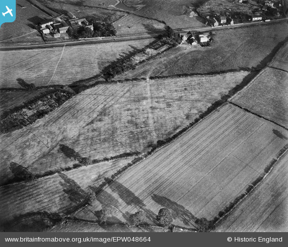
EPW048664 ENGLAND (1935). Farmland at Carrington's Farm, Smalley, 1935
© Copyright OpenStreetMap contributors and licensed by the OpenStreetMap Foundation. 2026. Cartography is licensed as CC BY-SA.
Nearby Images (48)
EPW048664

EAW012043

EAW012045

EAW012050

EAW012056

EAW012049

EAW012046

EAW025913

EAW017962

EAW011247

EPW048665

EAW011234

EAW012053

EAW025920

EAW011241

EAW018402

EAW011242

EAW018406

EAW012054

EAW011239

EAW011250

EAW011240

EAW025923

EPW048666

EAW011237

EAW011235

EAW018413

EAW018401

EAW018407

EAW011236

EAW011249

EAW011248

EAW018408

EAW018416

EAW011246

EAW018411

EAW018412

EAW012052

EAW017985

EAW017953

EAW017948

EAW017954

EAW017955

EAW033474

EAW018415

EAW025912

EAW033473

EAW017963

Details
| Title | [EPW048664] Farmland at Carrington's Farm, Smalley, 1935 |
| Reference | EPW048664 |
| Date | July-1935 |
| Link | |
| Place name | SMALLEY |
| Parish | SMALLEY |
| District | |
| Country | ENGLAND |
| Easting / Northing | 441057, 345268 |
| Longitude / Latitude | -1.3881144184056, 53.002845976948 |
| National Grid Reference | SK411453 |
Pins
 |

Class31 |
Monday 14th of April 2014 09:04:06 AM |
|
Class31 |
Monday 14th of April 2014 08:56:21 AM | |

ElmoEldridge |
Saturday 21st of December 2013 02:36:05 PM | |
|
TomRobin |
Monday 9th of December 2013 06:12:35 PM | |
I live in the cottage on the left and own the land to the rear of the cottages. |
NCooper |
Sunday 2nd of March 2014 08:51:26 PM |
|
TomRobin |
Monday 9th of December 2013 05:42:25 PM | |
|
TomRobin |
Monday 9th of December 2013 05:41:58 PM | |
|
TomRobin |
Tuesday 19th of November 2013 12:55:55 PM | |
|
nkingdon |
Friday 15th of November 2013 12:17:48 AM | |
appears to be some sort of green lane on the OS map |
TomRobin |
Monday 9th of December 2013 05:49:09 PM |
|
Class31 |
Thursday 23rd of May 2013 03:15:26 PM | |
Elongated shadows usually means the ground in the shadows is falling away e.g. side of a hill. |
BigglesH |
Friday 11th of October 2013 02:38:12 AM |
The whole set shows some degree of elongation, so it must be early morning or late afternoon, especially given that it's July. |
Tony D |
Friday 11th of October 2013 04:58:50 PM |
this means the road is running north south. There is a bus so presumably a mainish road |
TomRobin |
Tuesday 19th of November 2013 12:59:32 PM |

User Comment Contributions
Holly Mount Farm 12/04/2014 |
Class31 |
Monday 14th of April 2014 09:05:22 AM |
View looking south east. |
Class31 |
Thursday 9th of January 2014 11:19:31 AM |
Thanks for all the location details! We'll update the catalogue and post the new data here in due course. Yours, Katy Britain from Above Cataloguing Team Leader |
Katy Whitaker |
Wednesday 8th of January 2014 10:22:12 AM |
See same place in 1949 after opencast mining operations began EAW025913, not much left! |
TomRobin |
Saturday 4th of January 2014 09:22:02 PM |

Holly Mount Farm |
TomRobin |
Monday 9th of December 2013 06:21:11 PM |

Double line field boundary on OS map from Carrington Farm |
TomRobin |
Monday 9th of December 2013 05:46:31 PM |

Found it! These photos are of the the road from Smalley to Heanor. |
TomRobin |
Monday 9th of December 2013 05:38:13 PM |
I think (EPW048664) EPW048665 EPW048666 EPW048667 are of same area. |
Andrew Bennett |
Sunday 6th of October 2013 11:27:45 PM |