
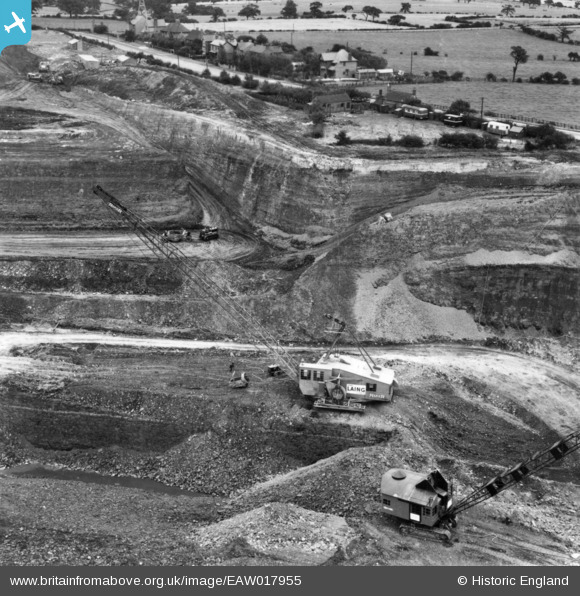
EAW017955 ENGLAND (1948). Opencast coal mining to the north of Carrington's Farm, Smalley, 1948. This image has been produced from a print.
© Copyright OpenStreetMap contributors and licensed by the OpenStreetMap Foundation. 2026. Cartography is licensed as CC BY-SA.
Nearby Images (48)
EAW017955

EAW017954

EAW018412

EAW018416

EAW011246

EAW017985

EAW011249

EAW018411

EAW025923

EAW018401

EAW011248

EAW012054

EAW018415

EAW018413

EAW018402

EPW048666

EAW011250

EAW017963

EAW025920

EAW018407

EAW025912

EAW011239

EAW018406

EAW011241

EAW017962

EAW012053

EPW048665

EAW033473

EAW011237

EAW011247

EAW011240

EAW011236

EAW011242

EAW033474

EAW012050

EAW012052

EAW011235

EAW011234

EAW012046

EAW012039

EAW012040

EAW012045

EAW012056

EPW048664

EAW012043

EAW011243

EAW025913

EAW033469

Details
| Title | [EAW017955] Opencast coal mining to the north of Carrington's Farm, Smalley, 1948. This image has been produced from a print. |
| Reference | EAW017955 |
| Date | 10-August-1948 |
| Link | |
| Place name | SMALLEY |
| Parish | SMALLEY |
| District | |
| Country | ENGLAND |
| Easting / Northing | 441268, 345386 |
| Longitude / Latitude | -1.3849549387435, 53.003890540085 |
| National Grid Reference | SK413454 |
Pins
Be the first to add a comment to this image!
User Comment Contributions

Rapier dragline |

Billy Turner |
Friday 10th of March 2017 06:32:31 PM |