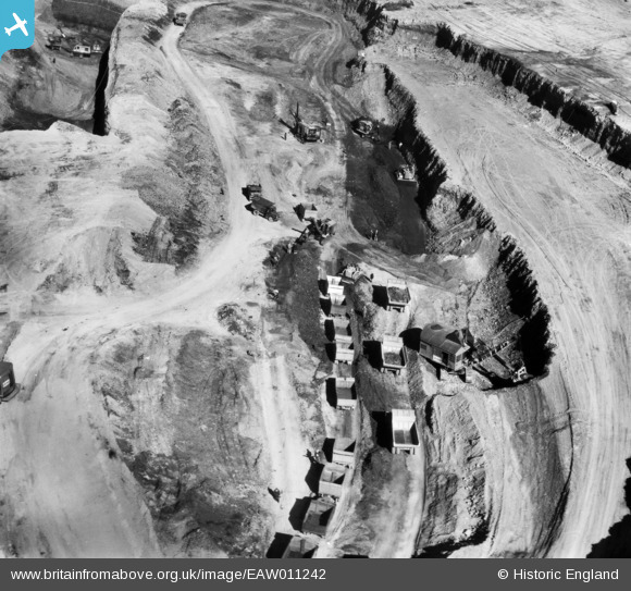
EAW011242 ENGLAND (1947). Opencast coal mining to the north of Holly Mount Farm, Smalley, 1947
© Copyright OpenStreetMap contributors and licensed by the OpenStreetMap Foundation. 2026. Cartography is licensed as CC BY-SA.
Nearby Images (48)
Details
| Title | [EAW011242] Opencast coal mining to the north of Holly Mount Farm, Smalley, 1947 |
| Reference | EAW011242 |
| Date | 30-September-1947 |
| Link | |
| Place name | SMALLEY |
| Parish | SMALLEY |
| District | |
| Country | ENGLAND |
| Easting / Northing | 441204, 345238 |
| Longitude / Latitude | -1.3859275946484, 53.002564994118 |
| National Grid Reference | SK412452 |
Pins

Billy Turner |
Monday 6th of March 2017 09:38:58 PM | |

Billy Turner |
Monday 6th of March 2017 09:09:16 PM | |

Billy Turner |
Sunday 9th of October 2016 07:47:20 PM | |

MB |
Sunday 24th of November 2013 10:04:34 AM | |

MB |
Sunday 24th of November 2013 10:04:09 AM |


![[EAW011242] Opencast coal mining to the north of Holly Mount Farm, Smalley, 1947](http://britainfromabove.org.uk/sites/all/libraries/aerofilms-images/public/100x100/EAW/011/EAW011242.jpg)
![[EAW011240] Opencast coal mining to the north of Holly Mount Farm, Smalley, 1947](http://britainfromabove.org.uk/sites/all/libraries/aerofilms-images/public/100x100/EAW/011/EAW011240.jpg)
![[EAW011247] Opencast coal mining to the north of Carrington's Farm, Smalley, 1947](http://britainfromabove.org.uk/sites/all/libraries/aerofilms-images/public/100x100/EAW/011/EAW011247.jpg)
![[EPW048665] Farmland at Carrington's Farm, Smalley, 1935](http://britainfromabove.org.uk/sites/all/libraries/aerofilms-images/public/100x100/EPW/048/EPW048665.jpg)
![[EAW018406] An opencast mining site to the north of the village, Smalley, 1948](http://britainfromabove.org.uk/sites/all/libraries/aerofilms-images/public/100x100/EAW/018/EAW018406.jpg)
![[EAW018407] An opencast mining site to the north of the village, Smalley, 1948](http://britainfromabove.org.uk/sites/all/libraries/aerofilms-images/public/100x100/EAW/018/EAW018407.jpg)
![[EAW012050] A Rapier crane at an opencast mining site opposite Holly Mount Farm, Smalley, 1947](http://britainfromabove.org.uk/sites/all/libraries/aerofilms-images/public/100x100/EAW/012/EAW012050.jpg)
![[EAW011250] Opencast coal mining to the north of Carrington's Farm, Smalley, 1947](http://britainfromabove.org.uk/sites/all/libraries/aerofilms-images/public/100x100/EAW/011/EAW011250.jpg)
![[EAW012046] A Rapier crane at an opencast mining site opposite Holly Mount Farm, Smalley, 1947](http://britainfromabove.org.uk/sites/all/libraries/aerofilms-images/public/100x100/EAW/012/EAW012046.jpg)
![[EPW048666] Farmland at Carrington's Farm, Smalley, 1935. This image has been produced from a damaged negative.](http://britainfromabove.org.uk/sites/all/libraries/aerofilms-images/public/100x100/EPW/048/EPW048666.jpg)
![[EAW018413] An opencast mining site to the north of the village, Smalley, 1948](http://britainfromabove.org.uk/sites/all/libraries/aerofilms-images/public/100x100/EAW/018/EAW018413.jpg)
![[EAW017962] Opencast coal mining to the north of Carrington's Farm, Smalley, 1948. This image has been produced from a damaged negative.](http://britainfromabove.org.uk/sites/all/libraries/aerofilms-images/public/100x100/EAW/017/EAW017962.jpg)
![[EAW011248] Opencast coal mining to the north of Carrington's Farm, Smalley, 1947](http://britainfromabove.org.uk/sites/all/libraries/aerofilms-images/public/100x100/EAW/011/EAW011248.jpg)
![[EAW012045] A Rapier crane at an opencast mining site opposite Holly Mount Farm, Smalley, 1947](http://britainfromabove.org.uk/sites/all/libraries/aerofilms-images/public/100x100/EAW/012/EAW012045.jpg)
![[EAW012056] A Rapier crane at an opencast mining site to the north of the village, Smalley, 1947](http://britainfromabove.org.uk/sites/all/libraries/aerofilms-images/public/100x100/EAW/012/EAW012056.jpg)
![[EAW025920] An opencast mining site adjacent to Heanor Road, Smalley, 1949. This image has been produced from a print.](http://britainfromabove.org.uk/sites/all/libraries/aerofilms-images/public/100x100/EAW/025/EAW025920.jpg)
![[EAW017953] Opencast coal mining to the north of Carrington's Farm, Smalley, 1948. This image has been produced from a print.](http://britainfromabove.org.uk/sites/all/libraries/aerofilms-images/public/100x100/EAW/017/EAW017953.jpg)
![[EAW012043] A Rapier crane at an opencast mining site opposite Holly Mount Farm, Smalley, 1947](http://britainfromabove.org.uk/sites/all/libraries/aerofilms-images/public/100x100/EAW/012/EAW012043.jpg)
![[EAW017985] Opencast coal mining to the north of Carrington's Farm, Smalley, 1948. This image has been produced from a print.](http://britainfromabove.org.uk/sites/all/libraries/aerofilms-images/public/100x100/EAW/017/EAW017985.jpg)
![[EAW025923] An opencast mining site adjacent to Heanor Road, Smalley, 1949. This image has been produced from a print.](http://britainfromabove.org.uk/sites/all/libraries/aerofilms-images/public/100x100/EAW/025/EAW025923.jpg)
![[EAW018402] An opencast mining site adjacent to Holly Mount Farm, Smalley, 1948](http://britainfromabove.org.uk/sites/all/libraries/aerofilms-images/public/100x100/EAW/018/EAW018402.jpg)
![[EAW011249] Opencast coal mining to the north of Carrington's Farm, Smalley, 1947](http://britainfromabove.org.uk/sites/all/libraries/aerofilms-images/public/100x100/EAW/011/EAW011249.jpg)
![[EAW012054] Opencast mining site to the north of the village, Smalley, from the north-east, 1947. This image was marked by Aerofilms Ltd for photo editing.](http://britainfromabove.org.uk/sites/all/libraries/aerofilms-images/public/100x100/EAW/012/EAW012054.jpg)
![[EAW018416] An opencast mining site to the north of the village, Smalley, 1948](http://britainfromabove.org.uk/sites/all/libraries/aerofilms-images/public/100x100/EAW/018/EAW018416.jpg)
![[EAW017948] Opencast coal mining to the north of Carrington's Farm, Smalley, 1948. This image has been produced from a print.](http://britainfromabove.org.uk/sites/all/libraries/aerofilms-images/public/100x100/EAW/017/EAW017948.jpg)
![[EPW048664] Farmland at Carrington's Farm, Smalley, 1935](http://britainfromabove.org.uk/sites/all/libraries/aerofilms-images/public/100x100/EPW/048/EPW048664.jpg)
![[EAW018412] An opencast mining site to the north of the village, Smalley, 1948](http://britainfromabove.org.uk/sites/all/libraries/aerofilms-images/public/100x100/EAW/018/EAW018412.jpg)
![[EAW018401] An opencast mining site to the north of the village, Smalley, 1948](http://britainfromabove.org.uk/sites/all/libraries/aerofilms-images/public/100x100/EAW/018/EAW018401.jpg)
![[EAW011246] Opencast coal mining to the north of Carrington's Farm, Smalley, 1947](http://britainfromabove.org.uk/sites/all/libraries/aerofilms-images/public/100x100/EAW/011/EAW011246.jpg)
![[EAW017955] Opencast coal mining to the north of Carrington's Farm, Smalley, 1948. This image has been produced from a print.](http://britainfromabove.org.uk/sites/all/libraries/aerofilms-images/public/100x100/EAW/017/EAW017955.jpg)
![[EAW033475] Restored opencast mining site near Carrington's Farm, Denby Village, 1950. This image was marked by Aerofilms Ltd for photo editing.](http://britainfromabove.org.uk/sites/all/libraries/aerofilms-images/public/100x100/EAW/033/EAW033475.jpg)
![[EAW017954] Opencast coal mining to the north of Carrington's Farm, Smalley, 1948. This image has been produced from a print.](http://britainfromabove.org.uk/sites/all/libraries/aerofilms-images/public/100x100/EAW/017/EAW017954.jpg)
![[EAW011241] Opencast coal mining to the north of Carrington's Farm, Smalley, 1947](http://britainfromabove.org.uk/sites/all/libraries/aerofilms-images/public/100x100/EAW/011/EAW011241.jpg)
![[EAW025913] An opencast mining site adjacent to Holly Mount Farm and Carrington's Farm, Smalley, from the south-west, 1949. This image was marked by Aerofilms Ltd for photo editing.](http://britainfromabove.org.uk/sites/all/libraries/aerofilms-images/public/100x100/EAW/025/EAW025913.jpg)
![[EAW012053] Opencast mining site to the north of the village, Smalley, 1947. This image was marked by Aerofilms Ltd for photo editing.](http://britainfromabove.org.uk/sites/all/libraries/aerofilms-images/public/100x100/EAW/012/EAW012053.jpg)
![[EAW017961] Opencast coal mining to the north of Carrington's Farm, Smalley, 1948. This image has been produced from a damaged negative.](http://britainfromabove.org.uk/sites/all/libraries/aerofilms-images/public/100x100/EAW/017/EAW017961.jpg)
![[EAW011239] Opencast coal mining to the north of Carrington's Farm, Smalley, 1947](http://britainfromabove.org.uk/sites/all/libraries/aerofilms-images/public/100x100/EAW/011/EAW011239.jpg)
![[EAW018411] A Rapier crane at an opencast mining site to the north of the village, Smalley, from the north, 1948](http://britainfromabove.org.uk/sites/all/libraries/aerofilms-images/public/100x100/EAW/018/EAW018411.jpg)
![[EAW025919] An opencast mining site adjacent to Heanor Road, Smalley, from the south, 1949](http://britainfromabove.org.uk/sites/all/libraries/aerofilms-images/public/100x100/EAW/025/EAW025919.jpg)
![[EAW011237] Opencast coal mining to the north of Carrington's Farm, Smalley, 1947](http://britainfromabove.org.uk/sites/all/libraries/aerofilms-images/public/100x100/EAW/011/EAW011237.jpg)
![[EAW012049] Opencast mining site to the north of the village, Smalley, 1947](http://britainfromabove.org.uk/sites/all/libraries/aerofilms-images/public/100x100/EAW/012/EAW012049.jpg)
![[EAW011234] Opencast coal mining to the north of Carrington's Farm, Smalley, 1947](http://britainfromabove.org.uk/sites/all/libraries/aerofilms-images/public/100x100/EAW/011/EAW011234.jpg)
![[EAW018408] Trucks queuing at the entrance to an opencast mining site adjacent to Carrington's Farm, Smalley, 1948](http://britainfromabove.org.uk/sites/all/libraries/aerofilms-images/public/100x100/EAW/018/EAW018408.jpg)
![[EAW011236] Opencast coal mining to the north of Carrington's Farm, Smalley, 1947](http://britainfromabove.org.uk/sites/all/libraries/aerofilms-images/public/100x100/EAW/011/EAW011236.jpg)
![[EAW018415] An opencast mining site to the north of the village, Smalley, from the north-west, 1948](http://britainfromabove.org.uk/sites/all/libraries/aerofilms-images/public/100x100/EAW/018/EAW018415.jpg)
![[EAW011235] Opencast coal mining to the north of Carrington's Farm, Smalley, 1947](http://britainfromabove.org.uk/sites/all/libraries/aerofilms-images/public/100x100/EAW/011/EAW011235.jpg)
![[EAW025912] An opencast mining site adjacent to Heanor Road, Smalley, 1949](http://britainfromabove.org.uk/sites/all/libraries/aerofilms-images/public/100x100/EAW/025/EAW025912.jpg)
![[EAW012052] Opencast mining site to the north of the village, Smalley, 1947](http://britainfromabove.org.uk/sites/all/libraries/aerofilms-images/public/100x100/EAW/012/EAW012052.jpg)


