
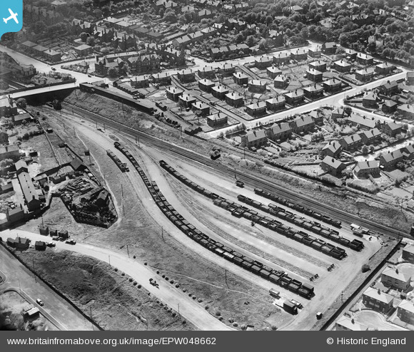
EPW048662 ENGLAND (1935). Railway sidings and adjacent housing, Crumpsall, 1935
© Copyright OpenStreetMap contributors and licensed by the OpenStreetMap Foundation. 2026. Cartography is licensed as CC BY-SA.
Nearby Images (12)
EPW048662

EPW048641

EPW048639

EPW048633

EPW047476

EPW048660

EPW047474

EPW048643

EPW047475

EPW046174

EPW047477

EPW017527

Details
| Title | [EPW048662] Railway sidings and adjacent housing, Crumpsall, 1935 |
| Reference | EPW048662 |
| Date | July-1935 |
| Link | |
| Place name | CRUMPSALL |
| Parish | |
| District | |
| Country | ENGLAND |
| Easting / Northing | 384058, 402541 |
| Longitude / Latitude | -2.2404658353099, 53.519052362027 |
| National Grid Reference | SD841025 |
Pins

totoro |
Friday 23rd of May 2014 09:16:11 PM | |
|
totoro |
Friday 23rd of May 2014 09:15:48 PM | |
|
totoro |
Friday 23rd of May 2014 09:02:01 PM | |
|
totoro |
Tuesday 26th of November 2013 06:19:27 PM | |
|
totoro |
Tuesday 26th of November 2013 06:16:27 PM | |
|
totoro |
Tuesday 26th of November 2013 06:16:03 PM | |
|
totoro |
Tuesday 26th of November 2013 06:15:31 PM | |
|
totoro |
Tuesday 26th of November 2013 06:15:08 PM | |
|
totoro |
Tuesday 26th of November 2013 06:13:50 PM | |
|
totoro |
Tuesday 26th of November 2013 06:12:22 PM | |
|
totoro |
Tuesday 26th of November 2013 06:11:42 PM | |
|
totoro |
Tuesday 26th of November 2013 06:11:16 PM |