
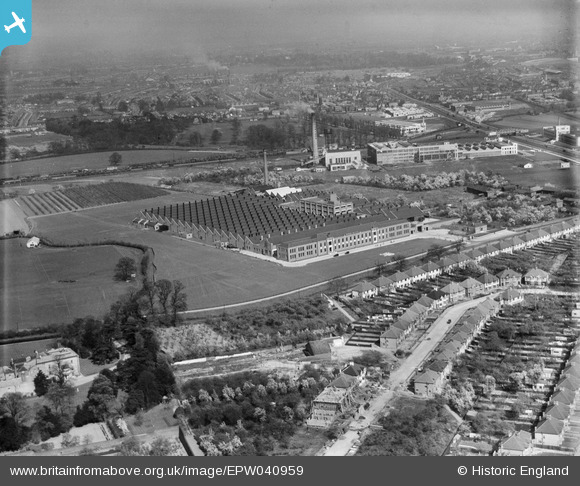
EPW040959 ENGLAND (1933). The Imperial Biscuit Works and environs, Brentford, from the south-west, 1933
© Copyright OpenStreetMap contributors and licensed by the OpenStreetMap Foundation. 2026. Cartography is licensed as CC BY-SA.
Nearby Images (14)
EPW040959

EPW035029

EPW035026

EPW035021

EPW035031

EPW035030

EPW035025

EPW027556

EPR000526

EPW034934

EPW035036

EPW031986

EPW032161

EPW040958

Details
| Title | [EPW040959] The Imperial Biscuit Works and environs, Brentford, from the south-west, 1933 |
| Reference | EPW040959 |
| Date | April-1933 |
| Link | |
| Place name | BRENTFORD |
| Parish | |
| District | |
| Country | ENGLAND |
| Easting / Northing | 515853, 177470 |
| Longitude / Latitude | -0.33133277609678, 51.483816426957 |
| National Grid Reference | TQ159775 |
Pins

Leslie B |
Saturday 18th of June 2022 02:14:57 PM | |
|
Leslie B |
Saturday 18th of June 2022 02:14:15 PM | |
|
Leslie B |
Saturday 18th of June 2022 02:13:49 PM | |
|
Bdog507 |
Monday 5th of July 2021 08:10:20 PM | |
|
Starman |
Wednesday 18th of March 2020 07:19:14 PM | |

Des Elmes |
Saturday 16th of April 2016 01:20:46 AM | |
|
The Laird |
Friday 9th of October 2015 09:04:26 PM | |
|
The Laird |
Friday 9th of October 2015 09:03:00 PM | |
|
Mozzy |
Thursday 25th of December 2014 10:25:59 PM |