EPW035026 ENGLAND (1931). Wyke House and the Great West Road, Osterley, 1931
    © Copyright OpenStreetMap contributors and licensed by the OpenStreetMap Foundation. 2025. Cartography is licensed as CC BY-SA.
  
Nearby Images (10)
Details
| Title | [EPW035026] Wyke House and the Great West Road, Osterley, 1931 | 
| Reference | EPW035026 | 
| Date | May-1931 | 
| Link | |
| Place name | OSTERLEY | 
| Parish | |
| District | |
| Country | ENGLAND | 
| Easting / Northing | 515932, 177339 | 
| Longitude / Latitude | -0.33023845006413, 51.48262271429 | 
| National Grid Reference | TQ159773 | 
Pins
|  Wyke House |   OldAdam | Tuesday 9th of August 2022 07:08:27 PM | 
|  Wyke Green |   OldAdam | Tuesday 9th of August 2022 07:08:11 PM | 
|  The Hare and Hounds Inn |   OldAdam | Tuesday 9th of August 2022 07:07:35 PM | 
|  Osterley Park Lake |   Mozzy | Sunday 28th of December 2014 10:49:32 PM | 
|  Gate Houses Osterley Park |   Mozzy | Sunday 28th of December 2014 10:48:26 PM | 
User Comment Contributions
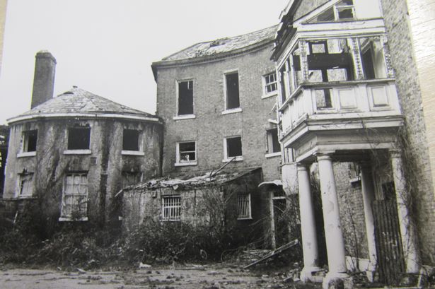
|   Wyke House was an interesting building. A manor House had stood on the site since the 16th century, which I believe was built by Sir Thomas Gresham who founded the royal exchange. It was purchased in around 1778 by John Robinson who was a Government official, & he rebuilt the house & renamed it Wyke House. After his death, his widow & offspring continued to live there.  However,sometime in the 19th century it became a school, & then a lunatic asylum. It was still used for mental health purposes until around 1970. It then became derelict. I remember it was riddled with damp & dry rot, & despite being grade 11 listed it was demolished in late 1977. A housing estate named Wyke Close now stands where the house was. |   Bdog507 | Sunday 26th of October 2014 10:34:59 AM | 
 
             
  ![[EPW035026] Wyke House and the Great West Road, Osterley, 1931](http://britainfromabove.org.uk/sites/all/libraries/aerofilms-images/public/100x100/EPW/035/EPW035026.jpg) 
  
                                          ![[EPW035021] The Imperial Biscuit Works, Firestone Rubber Tyre Manufactory and the Great West Road, Osterley, 1931](http://britainfromabove.org.uk/sites/all/libraries/aerofilms-images/public/100x100/EPW/035/EPW035021.jpg) 
 ![[EPW035025] The Great West Road and construction of housing on Syon Lane, Osterley, 1931](http://britainfromabove.org.uk/sites/all/libraries/aerofilms-images/public/100x100/EPW/035/EPW035025.jpg) 
 ![[EPW035029] The Great West Road and construction of housing on Syon Lane, Osterley, 1931](http://britainfromabove.org.uk/sites/all/libraries/aerofilms-images/public/100x100/EPW/035/EPW035029.jpg) 
 ![[EPR000526] The Church of St Francis of Assisi on the Great West Road, Spring Grove, 1935](http://britainfromabove.org.uk/sites/all/libraries/aerofilms-images/public/100x100/EPR/000/EPR000526.jpg) 
 ![[EPW035031] The Imperial Biscuit Works, Firestone Rubber Tyre Manufactory and the Great West Road, Osterley, 1931](http://britainfromabove.org.uk/sites/all/libraries/aerofilms-images/public/100x100/EPW/035/EPW035031.jpg) 
 ![[EPW035030] The Imperial Biscuit Works and the Great West Road, Osterley, 1931](http://britainfromabove.org.uk/sites/all/libraries/aerofilms-images/public/100x100/EPW/035/EPW035030.jpg) 
 ![[EPW035036] The Great West Road and construction of new housing on Syon Lane, Osterley, 1931](http://britainfromabove.org.uk/sites/all/libraries/aerofilms-images/public/100x100/EPW/035/EPW035036.jpg) 
 ![[EPW040959] The Imperial Biscuit Works and environs, Brentford, from the south-west, 1933](http://britainfromabove.org.uk/sites/all/libraries/aerofilms-images/public/100x100/EPW/040/EPW040959.jpg) 
 ![[EPR000689] The Great West Road at Brentford End, Brentford, from the south-west, 1935](http://britainfromabove.org.uk/sites/all/libraries/aerofilms-images/public/100x100/EPR/000/EPR000689.jpg)