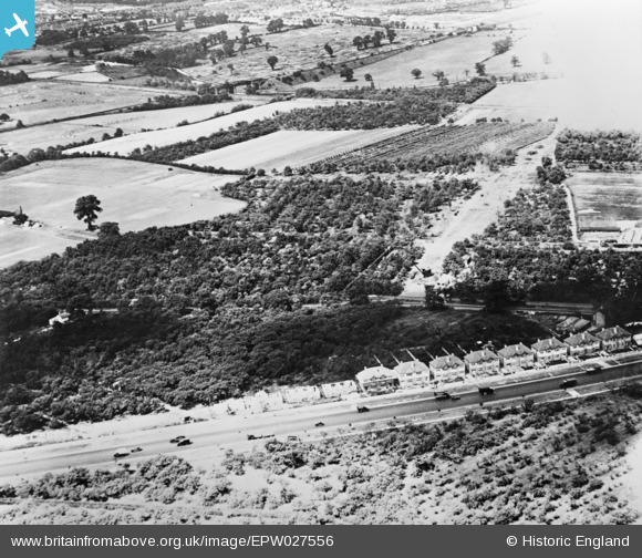
EPW027556 ENGLAND (1929). Housing under construction between the Great West Road and Syon Lane, Osterley, 1929. This image has been produced from a copy-negative.
    © Copyright OpenStreetMap contributors and licensed by the OpenStreetMap Foundation. 2025. Cartography is licensed as CC BY-SA.
  
Nearby Images (10)
Details
| Title | [EPW027556] Housing under construction between the Great West Road and Syon Lane, Osterley, 1929. This image has been produced from a copy-negative. | 
| Reference | EPW027556 | 
| Date | July-1929 | 
| Link | |
| Place name | OSTERLEY | 
| Parish | |
| District | |
| Country | ENGLAND | 
| Easting / Northing | 515985, 177628 | 
| Longitude / Latitude | -0.32938049726929, 51.485209581823 | 
| National Grid Reference | TQ160776 | 
Pins
|  The newly Built Royal Hotel, today's Harvester on the Boston Road. |   Leslie B | Saturday 18th of June 2022 02:10:05 PM | 
|  GWR line from Southall to Brentford Docks. |   Leslie B | Saturday 18th of June 2022 02:08:45 PM | 
|  District Railway Bridge (now Piccadilly Line) over the River Brent/Grand Union Canal. The Southern end has an arch over the GWR line from Southall to Brentford Docks. |   Leslie B | Saturday 18th of June 2022 02:07:57 PM | 
|  Boston Manor Station, then District Railway, today's Piccadilly Line to Heathrow. |   Leslie B | Saturday 18th of June 2022 02:06:16 PM | 
|  M4 cuts through this field today |   TomRobin | Sunday 2nd of November 2014 05:21:54 PM | 
|  Allotments, still there |   TomRobin | Sunday 2nd of November 2014 05:20:26 PM | 
|  Townholm Crescent |   TomRobin | Sunday 2nd of November 2014 05:18:52 PM | 
|  Syon Lane now B454 |   TomRobin | Sunday 2nd of November 2014 05:17:13 PM | 
|  This house with the sloping gables is still visible as the only one in the row with a different roof design |   TomRobin | Sunday 2nd of November 2014 05:16:24 PM | 
|  This house is on the corner of Syon Park Gardens where it meets the Great West Road. |   TomRobin | Sunday 2nd of November 2014 05:15:04 PM | 
|  River Brent |   TomRobin | Sunday 2nd of November 2014 05:08:50 PM | 
|  Major new road here,  bypass to town above? |   TomRobin | Sunday 2nd of November 2014 04:57:49 PM | 
| A4 Great West Road |   TomRobin | Sunday 2nd of November 2014 05:07:09 PM | 
|  I think there is another railway parallel to the canal, in a cutting. note bridges and poles. |   TomRobin | Sunday 2nd of November 2014 04:56:18 PM | 
| That is the GWR's Brentford Branch. |   Isleworth1961 | Monday 24th of November 2014 09:16:21 PM | 
|  A station with covered "train shed"? |   flubber | Sunday 2nd of November 2014 01:37:06 PM | 
| Boston Manor Park |   TomRobin | Sunday 2nd of November 2014 05:08:12 PM | 
| Station is named Boston Manor | Class31 | Sunday 2nd of November 2014 06:22:58 PM | 
| The covered train sheds are still there between Boston Manor and Northfields stations |   Mozzy | Monday 31st of October 2016 07:12:58 PM | 
|  Lattice girder bridge taking a railway line over a canal? |   flubber | Sunday 2nd of November 2014 01:34:04 PM | 
| This is the bridge that carries what is now the Piccadilly Line over the Grand Union Canal, and what is left of the GWR's Brentford Branch. |   Isleworth1961 | Monday 24th of November 2014 09:14:54 PM | 
 
             
  ![[EPW027556] Housing under construction between the Great West Road and Syon Lane, Osterley, 1929. This image has been produced from a copy-negative.](http://britainfromabove.org.uk/sites/all/libraries/aerofilms-images/public/100x100/EPW/027/EPW027556.jpg) 
  
                                          ![[EPW034934] The Imperial Biscuit Works and the Firestone Rubber Tyre Manufactory, Osterley, 1931](http://britainfromabove.org.uk/sites/all/libraries/aerofilms-images/public/100x100/EPW/034/EPW034934.jpg) 
 ![[EPW031986] The MacFarlane Lang and Co Imperial Biscuit Works under construction, Osterley, 1930](http://britainfromabove.org.uk/sites/all/libraries/aerofilms-images/public/100x100/EPW/031/EPW031986.jpg) 
 ![[EPW032161] The Imperial Biscuit Works under construction and environs, Brentford, 1930](http://britainfromabove.org.uk/sites/all/libraries/aerofilms-images/public/100x100/EPW/032/EPW032161.jpg) 
 ![[EPW040958] The Imperial Biscuit Works, Brentford, 1933](http://britainfromabove.org.uk/sites/all/libraries/aerofilms-images/public/100x100/EPW/040/EPW040958.jpg) 
 ![[EPW034933] The Imperial Biscuit Works, Osterley, 1931](http://britainfromabove.org.uk/sites/all/libraries/aerofilms-images/public/100x100/EPW/034/EPW034933.jpg) 
 ![[EPW040960] The Imperial Biscuit Works and environs, Brentford, 1933](http://britainfromabove.org.uk/sites/all/libraries/aerofilms-images/public/100x100/EPW/040/EPW040960.jpg) 
 ![[EPW034932] The Imperial Biscuit Works, Osterley, 1931](http://britainfromabove.org.uk/sites/all/libraries/aerofilms-images/public/100x100/EPW/034/EPW034932.jpg) 
 ![[EPW040959] The Imperial Biscuit Works and environs, Brentford, from the south-west, 1933](http://britainfromabove.org.uk/sites/all/libraries/aerofilms-images/public/100x100/EPW/040/EPW040959.jpg) 
 ![[EPW035030] The Imperial Biscuit Works and the Great West Road, Osterley, 1931](http://britainfromabove.org.uk/sites/all/libraries/aerofilms-images/public/100x100/EPW/035/EPW035030.jpg)