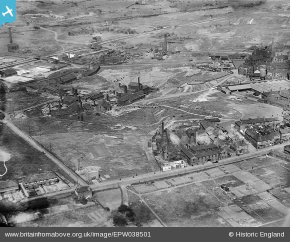
EPW038501 ENGLAND (1932). The Brownhills Tileries and the Brownhills Pottery Works, Tunstall, 1932
© Copyright OpenStreetMap contributors and licensed by the OpenStreetMap Foundation. 2026. Cartography is licensed as CC BY-SA.
Nearby Images (27)
Details
| Title | [EPW038501] The Brownhills Tileries and the Brownhills Pottery Works, Tunstall, 1932 |
| Reference | EPW038501 |
| Date | June-1932 |
| Link | |
| Place name | TUNSTALL |
| Parish | |
| District | |
| Country | ENGLAND |
| Easting / Northing | 385844, 350707 |
| Longitude / Latitude | -2.2112159212723, 53.053130213533 |
| National Grid Reference | SJ858507 |
Pins

bescotbeast |
Friday 24th of January 2025 11:39:03 AM | |

bescotbeast |
Friday 24th of January 2025 11:38:19 AM | |

bescotbeast |
Friday 24th of January 2025 11:36:23 AM | |

bescotbeast |
Friday 24th of January 2025 11:35:39 AM | |

bescotbeast |
Friday 24th of January 2025 11:34:44 AM | |

bescotbeast |
Friday 24th of January 2025 11:34:16 AM | |

bescotbeast |
Friday 24th of January 2025 11:29:35 AM | |

bescotbeast |
Friday 24th of January 2025 11:29:15 AM | |

bescotbeast |
Friday 24th of January 2025 11:26:43 AM | |

bescotbeast |
Friday 24th of January 2025 11:26:22 AM |


![[EPW038501] The Brownhills Tileries and the Brownhills Pottery Works, Tunstall, 1932](http://britainfromabove.org.uk/sites/all/libraries/aerofilms-images/public/100x100/EPW/038/EPW038501.jpg)
![[EPW038500] The Brownhills Tileries, Tunstall, 1932](http://britainfromabove.org.uk/sites/all/libraries/aerofilms-images/public/100x100/EPW/038/EPW038500.jpg)
![[EPW038502] The Brownhills Tileries, St Mary's Church and environs, Tunstall, 1932](http://britainfromabove.org.uk/sites/all/libraries/aerofilms-images/public/100x100/EPW/038/EPW038502.jpg)
![[EPW038497] The Brownhills Tileries, Tunstall, 1932](http://britainfromabove.org.uk/sites/all/libraries/aerofilms-images/public/100x100/EPW/038/EPW038497.jpg)
![[EPW038499] The Brownhills Tileries, St Mary's Church and environs, Tunstall, 1932](http://britainfromabove.org.uk/sites/all/libraries/aerofilms-images/public/100x100/EPW/038/EPW038499.jpg)
![[EPW038498] The Brownhills Tileries and environs, Tunstall, 1932](http://britainfromabove.org.uk/sites/all/libraries/aerofilms-images/public/100x100/EPW/038/EPW038498.jpg)
![[EAW027946] The Richards Tiles Ltd Brownhills Tile Works, Tunstall, 1950. This image has been produced from a print.](http://britainfromabove.org.uk/sites/all/libraries/aerofilms-images/public/100x100/EAW/027/EAW027946.jpg)
![[EAW028408] The Richards Tiles Ltd Brownhills Tile Works, Tunstall, 1950. This image was marked by Aerofilms Ltd for photo editing.](http://britainfromabove.org.uk/sites/all/libraries/aerofilms-images/public/100x100/EAW/028/EAW028408.jpg)
![[EPW047626] Brownhills Tile Works, Tunstall, 1935](http://britainfromabove.org.uk/sites/all/libraries/aerofilms-images/public/100x100/EPW/047/EPW047626.jpg)
![[EAW028410] The Richards Tiles Ltd Brownhills Tile Works, Tunstall, 1950. This image was marked by Aerofilms Ltd for photo editing.](http://britainfromabove.org.uk/sites/all/libraries/aerofilms-images/public/100x100/EAW/028/EAW028410.jpg)
![[EAW028407] The Richards Tiles Ltd Brownhills Tile Works, Tunstall, 1950. This image was marked by Aerofilms Ltd for photo editing.](http://britainfromabove.org.uk/sites/all/libraries/aerofilms-images/public/100x100/EAW/028/EAW028407.jpg)
![[EAW027947] The Richards Tiles Ltd Brownhills Tile Works and Westport Lake, Tunstall, 1950. This image has been produced from a print.](http://britainfromabove.org.uk/sites/all/libraries/aerofilms-images/public/100x100/EAW/027/EAW027947.jpg)
![[EAW028404] The Richards Tiles Ltd Brownhills Tile Works, Tunstall, 1950. This image was marked by Aerofilms Ltd for photo editing.](http://britainfromabove.org.uk/sites/all/libraries/aerofilms-images/public/100x100/EAW/028/EAW028404.jpg)
![[EPW047627] Brownhills Tile Works, Tunstall, 1935](http://britainfromabove.org.uk/sites/all/libraries/aerofilms-images/public/100x100/EPW/047/EPW047627.jpg)
![[EAW028405] The Richards Tiles Ltd Brownhills Tile Works, Tunstall, 1950. This image was marked by Aerofilms Ltd for photo editing.](http://britainfromabove.org.uk/sites/all/libraries/aerofilms-images/public/100x100/EAW/028/EAW028405.jpg)
![[EPW047624] Brownhills Tile Works, Tunstall, 1935](http://britainfromabove.org.uk/sites/all/libraries/aerofilms-images/public/100x100/EPW/047/EPW047624.jpg)
![[EPW047625] Brownhills Tile Works, Tunstall, 1935](http://britainfromabove.org.uk/sites/all/libraries/aerofilms-images/public/100x100/EPW/047/EPW047625.jpg)
![[EPW047628] Brownhills Tile Works, Tunstall, 1935](http://britainfromabove.org.uk/sites/all/libraries/aerofilms-images/public/100x100/EPW/047/EPW047628.jpg)
![[EAW027940] The Richards Tiles Ltd Brownhills Tile Works, Tunstall, 1950](http://britainfromabove.org.uk/sites/all/libraries/aerofilms-images/public/100x100/EAW/027/EAW027940.jpg)
![[EAW027942] The Richards Tiles Ltd Brownhills Tile Works, Tunstall, 1950. This image was marked by Aerofilms Ltd for photo editing.](http://britainfromabove.org.uk/sites/all/libraries/aerofilms-images/public/100x100/EAW/027/EAW027942.jpg)
![[EAW028402] The Richards Tiles Ltd Brownhills Tile Works, Tunstall, 1950. This image was marked by Aerofilms Ltd for photo editing.](http://britainfromabove.org.uk/sites/all/libraries/aerofilms-images/public/100x100/EAW/028/EAW028402.jpg)
![[EAW027944] The Richards Tiles Ltd Brownhills Tile Works, Tunstall, 1950. This image was marked by Aerofilms Ltd for photo editing.](http://britainfromabove.org.uk/sites/all/libraries/aerofilms-images/public/100x100/EAW/027/EAW027944.jpg)
![[EAW028403] The Richards Tiles Ltd Brownhills Tile Works, Tunstall, 1950. This image was marked by Aerofilms Ltd for photo editing.](http://britainfromabove.org.uk/sites/all/libraries/aerofilms-images/public/100x100/EAW/028/EAW028403.jpg)
![[EAW027941] The Richards Tiles Ltd Brownhills Tile Works, Tunstall, 1950](http://britainfromabove.org.uk/sites/all/libraries/aerofilms-images/public/100x100/EAW/027/EAW027941.jpg)
![[EAW027945] The Richards Tiles Ltd Brownhills Tile Works, Tunstall, 1950. This image has been produced from a print marked by Aerofilms Ltd for photo editing.](http://britainfromabove.org.uk/sites/all/libraries/aerofilms-images/public/100x100/EAW/027/EAW027945.jpg)
![[EPW047622] Brownhills Tile Works, Tunstall, 1935](http://britainfromabove.org.uk/sites/all/libraries/aerofilms-images/public/100x100/EPW/047/EPW047622.jpg)
![[EPW047623] Brownhills Tile Works, Tunstall, 1935](http://britainfromabove.org.uk/sites/all/libraries/aerofilms-images/public/100x100/EPW/047/EPW047623.jpg)