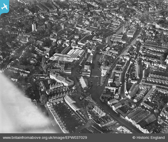
EPW037029 ENGLAND (1931). H.G. Simonds Seven Bridges Brewery and the River Kennet, Reading, 1931
© Copyright OpenStreetMap contributors and licensed by the OpenStreetMap Foundation. 2026. Cartography is licensed as CC BY-SA.
Nearby Images (18)
Details
| Title | [EPW037029] H.G. Simonds Seven Bridges Brewery and the River Kennet, Reading, 1931 |
| Reference | EPW037029 |
| Date | October-1931 |
| Link | |
| Place name | READING |
| Parish | |
| District | |
| Country | ENGLAND |
| Easting / Northing | 471413, 173034 |
| Longitude / Latitude | -0.9721673312971, 51.45129197034 |
| National Grid Reference | SU714730 |
Pins

Mikkel |
Thursday 12th of October 2017 12:03:20 PM |


![[EPW037029] H.G. Simonds Seven Bridges Brewery and the River Kennet, Reading, 1931](http://britainfromabove.org.uk/sites/all/libraries/aerofilms-images/public/100x100/EPW/037/EPW037029.jpg)
![[EPW037031] H.G. Simonds Seven Bridges Brewery and the town centre, Reading, 1931](http://britainfromabove.org.uk/sites/all/libraries/aerofilms-images/public/100x100/EPW/037/EPW037031.jpg)
![[EPW037026] H.G. Simonds Seven Bridges Brewery and town around the River Kennet, Reading, 1931](http://britainfromabove.org.uk/sites/all/libraries/aerofilms-images/public/100x100/EPW/037/EPW037026.jpg)
![[EPW037484] The Seven Bridges Brewery and Malthouses alongside the River Kennet, housing surrounding Henry Street and the town, Reading, 1932. This image has been affected by flare.](http://britainfromabove.org.uk/sites/all/libraries/aerofilms-images/public/100x100/EPW/037/EPW037484.jpg)
![[EPW037482] The Seven Bridges Brewery and Malthouses alongside the River Kennet, St Mary's Church and the town, Reading, 1932](http://britainfromabove.org.uk/sites/all/libraries/aerofilms-images/public/100x100/EPW/037/EPW037482.jpg)
![[EPW037486] The Seven Bridges Brewery and Malthouses alongside the River Kennet and the town, Reading, 1932](http://britainfromabove.org.uk/sites/all/libraries/aerofilms-images/public/100x100/EPW/037/EPW037486.jpg)
![[EPW037030] H.G. Simonds Seven Bridges Brewery and environs, Reading, 1931](http://britainfromabove.org.uk/sites/all/libraries/aerofilms-images/public/100x100/EPW/037/EPW037030.jpg)
![[EPW037027] H.G. Simonds Seven Bridges Brewery, Reading, 1931](http://britainfromabove.org.uk/sites/all/libraries/aerofilms-images/public/100x100/EPW/037/EPW037027.jpg)
![[EPW037481] The Seven Bridges Brewery alongside the River Kennet, St Mary's Church and the town, Reading, 1932](http://britainfromabove.org.uk/sites/all/libraries/aerofilms-images/public/100x100/EPW/037/EPW037481.jpg)
![[EPW037485] The Seven Bridges Brewery and Malthouses alongside the River Kennet, housing surrounding Henry Street and the town, Reading, 1932](http://britainfromabove.org.uk/sites/all/libraries/aerofilms-images/public/100x100/EPW/037/EPW037485.jpg)
![[EPW037487] The Seven Bridges Brewery and Malthouses alongside the River Kennet and the town, Reading, 1932](http://britainfromabove.org.uk/sites/all/libraries/aerofilms-images/public/100x100/EPW/037/EPW037487.jpg)
![[EPW037495] The Seven Bridges Brewery and Malthouses alongside the River Kennet, St Mary's Church and the town, Reading, 1932](http://britainfromabove.org.uk/sites/all/libraries/aerofilms-images/public/100x100/EPW/037/EPW037495.jpg)
![[EPW037028] H.G. Simonds Seven Bridges Brewery, Reading, 1931](http://britainfromabove.org.uk/sites/all/libraries/aerofilms-images/public/100x100/EPW/037/EPW037028.jpg)
![[EPW037483] The Seven Bridges Brewery alongside the River Kennet and the town, Reading, 1932](http://britainfromabove.org.uk/sites/all/libraries/aerofilms-images/public/100x100/EPW/037/EPW037483.jpg)
![[EPW037488] The Seven Bridges Brewery and Malthouses alongside the River Kennet and the town, Reading, 1932](http://britainfromabove.org.uk/sites/all/libraries/aerofilms-images/public/100x100/EPW/037/EPW037488.jpg)
![[EPW037489] The Seven Bridges Brewery and Malthouses alongside the River Kennet, The Tram and Bus Depot and the town, Reading, 1932](http://britainfromabove.org.uk/sites/all/libraries/aerofilms-images/public/100x100/EPW/037/EPW037489.jpg)
![[EAW015081] The town, Reading, from the south, 1948](http://britainfromabove.org.uk/sites/all/libraries/aerofilms-images/public/100x100/EAW/015/EAW015081.jpg)
![[EPW022681] St Mary's Church and St Mary's Butts, Reading, 1928](http://britainfromabove.org.uk/sites/all/libraries/aerofilms-images/public/100x100/EPW/022/EPW022681.jpg)