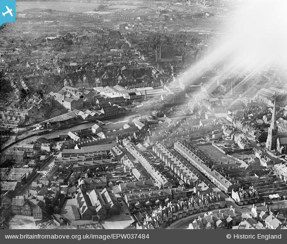
EPW037484 ENGLAND (1932). The Seven Bridges Brewery and Malthouses alongside the River Kennet, housing surrounding Henry Street and the town, Reading, 1932. This image has been affected by flare.
© Copyright OpenStreetMap contributors and licensed by the OpenStreetMap Foundation. 2026. Cartography is licensed as CC BY-SA.
Nearby Images (17)
Details
| Title | [EPW037484] The Seven Bridges Brewery and Malthouses alongside the River Kennet, housing surrounding Henry Street and the town, Reading, 1932. This image has been affected by flare. |
| Reference | EPW037484 |
| Date | April-1932 |
| Link | |
| Place name | READING |
| Parish | |
| District | |
| Country | ENGLAND |
| Easting / Northing | 471455, 173023 |
| Longitude / Latitude | -0.97156516092549, 51.451187767737 |
| National Grid Reference | SU715730 |
Pins
Be the first to add a comment to this image!


![[EPW037484] The Seven Bridges Brewery and Malthouses alongside the River Kennet, housing surrounding Henry Street and the town, Reading, 1932. This image has been affected by flare.](http://britainfromabove.org.uk/sites/all/libraries/aerofilms-images/public/100x100/EPW/037/EPW037484.jpg)
![[EPW037026] H.G. Simonds Seven Bridges Brewery and town around the River Kennet, Reading, 1931](http://britainfromabove.org.uk/sites/all/libraries/aerofilms-images/public/100x100/EPW/037/EPW037026.jpg)
![[EPW037029] H.G. Simonds Seven Bridges Brewery and the River Kennet, Reading, 1931](http://britainfromabove.org.uk/sites/all/libraries/aerofilms-images/public/100x100/EPW/037/EPW037029.jpg)
![[EPW037486] The Seven Bridges Brewery and Malthouses alongside the River Kennet and the town, Reading, 1932](http://britainfromabove.org.uk/sites/all/libraries/aerofilms-images/public/100x100/EPW/037/EPW037486.jpg)
![[EPW037481] The Seven Bridges Brewery alongside the River Kennet, St Mary's Church and the town, Reading, 1932](http://britainfromabove.org.uk/sites/all/libraries/aerofilms-images/public/100x100/EPW/037/EPW037481.jpg)
![[EPW037485] The Seven Bridges Brewery and Malthouses alongside the River Kennet, housing surrounding Henry Street and the town, Reading, 1932](http://britainfromabove.org.uk/sites/all/libraries/aerofilms-images/public/100x100/EPW/037/EPW037485.jpg)
![[EPW037487] The Seven Bridges Brewery and Malthouses alongside the River Kennet and the town, Reading, 1932](http://britainfromabove.org.uk/sites/all/libraries/aerofilms-images/public/100x100/EPW/037/EPW037487.jpg)
![[EPW037482] The Seven Bridges Brewery and Malthouses alongside the River Kennet, St Mary's Church and the town, Reading, 1932](http://britainfromabove.org.uk/sites/all/libraries/aerofilms-images/public/100x100/EPW/037/EPW037482.jpg)
![[EPW037031] H.G. Simonds Seven Bridges Brewery and the town centre, Reading, 1931](http://britainfromabove.org.uk/sites/all/libraries/aerofilms-images/public/100x100/EPW/037/EPW037031.jpg)
![[EPW037495] The Seven Bridges Brewery and Malthouses alongside the River Kennet, St Mary's Church and the town, Reading, 1932](http://britainfromabove.org.uk/sites/all/libraries/aerofilms-images/public/100x100/EPW/037/EPW037495.jpg)
![[EPW037483] The Seven Bridges Brewery alongside the River Kennet and the town, Reading, 1932](http://britainfromabove.org.uk/sites/all/libraries/aerofilms-images/public/100x100/EPW/037/EPW037483.jpg)
![[EPW037030] H.G. Simonds Seven Bridges Brewery and environs, Reading, 1931](http://britainfromabove.org.uk/sites/all/libraries/aerofilms-images/public/100x100/EPW/037/EPW037030.jpg)
![[EPW037027] H.G. Simonds Seven Bridges Brewery, Reading, 1931](http://britainfromabove.org.uk/sites/all/libraries/aerofilms-images/public/100x100/EPW/037/EPW037027.jpg)
![[EPW037488] The Seven Bridges Brewery and Malthouses alongside the River Kennet and the town, Reading, 1932](http://britainfromabove.org.uk/sites/all/libraries/aerofilms-images/public/100x100/EPW/037/EPW037488.jpg)
![[EPW037028] H.G. Simonds Seven Bridges Brewery, Reading, 1931](http://britainfromabove.org.uk/sites/all/libraries/aerofilms-images/public/100x100/EPW/037/EPW037028.jpg)
![[EPW037489] The Seven Bridges Brewery and Malthouses alongside the River Kennet, The Tram and Bus Depot and the town, Reading, 1932](http://britainfromabove.org.uk/sites/all/libraries/aerofilms-images/public/100x100/EPW/037/EPW037489.jpg)
![[EAW015081] The town, Reading, from the south, 1948](http://britainfromabove.org.uk/sites/all/libraries/aerofilms-images/public/100x100/EAW/015/EAW015081.jpg)