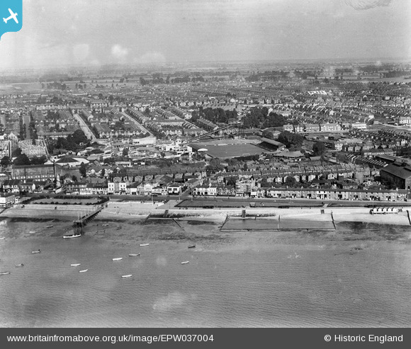
EPW037004 ENGLAND (1931). The Kursaal and environs, Southend-on-Sea, from the south-west, 1931
© Copyright OpenStreetMap contributors and licensed by the OpenStreetMap Foundation. 2026. Cartography is licensed as CC BY-SA.
Nearby Images (18)
Details
| Title | [EPW037004] The Kursaal and environs, Southend-on-Sea, from the south-west, 1931 |
| Reference | EPW037004 |
| Date | October-1931 |
| Link | |
| Place name | SOUTHEND-ON-SEA |
| Parish | |
| District | |
| Country | ENGLAND |
| Easting / Northing | 589215, 184847 |
| Longitude / Latitude | 0.72824373096496, 51.530297821464 |
| National Grid Reference | TQ892848 |


![[EPW037004] The Kursaal and environs, Southend-on-Sea, from the south-west, 1931](http://britainfromabove.org.uk/sites/all/libraries/aerofilms-images/public/100x100/EPW/037/EPW037004.jpg)
![[EPW040962] The Southend Flat, the Eastern Esplanade and the town, Southend-on-Sea, from the south-east, 1933](http://britainfromabove.org.uk/sites/all/libraries/aerofilms-images/public/100x100/EPW/040/EPW040962.jpg)
![[EPW037003] The Kursaal and environs, Southend-on-Sea, from the south, 1931](http://britainfromabove.org.uk/sites/all/libraries/aerofilms-images/public/100x100/EPW/037/EPW037003.jpg)
![[EPW040961] The Southend Flat, Marine Parade and the town, Southend-on-Sea, from the south-east, 1933](http://britainfromabove.org.uk/sites/all/libraries/aerofilms-images/public/100x100/EPW/040/EPW040961.jpg)
![[EPW024887] The seafront, the Kursaal and the town beyond, Southend-on-Sea, from the south-east, 1928](http://britainfromabove.org.uk/sites/all/libraries/aerofilms-images/public/100x100/EPW/024/EPW024887.jpg)
![[EAW024660] The waterfront and town from Corporation Landing Pier to The Shrubbery and beyond, Southend-on-Sea, from the east, 1949](http://britainfromabove.org.uk/sites/all/libraries/aerofilms-images/public/100x100/EAW/024/EAW024660.jpg)
![[EPW036736] The Corporation Loading Pier and the Eastern Esplanade Gas Works, Southend-on-Sea, 1931](http://britainfromabove.org.uk/sites/all/libraries/aerofilms-images/public/100x100/EPW/036/EPW036736.jpg)
![[EPW040965] The Corporation Loading Pier, the Eastern Esplanade and the town, Southend-on-Sea, from the south-east, 1933](http://britainfromabove.org.uk/sites/all/libraries/aerofilms-images/public/100x100/EPW/040/EPW040965.jpg)
![[EAW053086] The seafront and Kursaal looking along Southchurch Avenue, Southend-on-Sea, from the south, 1954](http://britainfromabove.org.uk/sites/all/libraries/aerofilms-images/public/100x100/EAW/053/EAW053086.jpg)
![[EPW000444] Kursaal, Southend-on-Sea, 1920](http://britainfromabove.org.uk/sites/all/libraries/aerofilms-images/public/100x100/EPW/000/EPW000444.jpg)
![[EPW036995] The Kursaal, Southchurch Avenue and environs, Southend-on-Sea, from the south-west, 1931](http://britainfromabove.org.uk/sites/all/libraries/aerofilms-images/public/100x100/EPW/036/EPW036995.jpg)
![[EPW058226] The Kursaal, Southend-on-Sea, from the south-west, 1938](http://britainfromabove.org.uk/sites/all/libraries/aerofilms-images/public/100x100/EPW/058/EPW058226.jpg)
![[EPW036726] The Eastern Esplanade, the Kursaal Zoo and Amusement Park and environs, Southend-on-Sea, 1931](http://britainfromabove.org.uk/sites/all/libraries/aerofilms-images/public/100x100/EPW/036/EPW036726.jpg)
![[EPW062745] The Kursaal with Southend Pier in the distance, Southend-on-Sea, 1939](http://britainfromabove.org.uk/sites/all/libraries/aerofilms-images/public/100x100/EPW/062/EPW062745.jpg)
![[EAW002219] The sea front at Marine Parade, Southend-on-Sea, 1946](http://britainfromabove.org.uk/sites/all/libraries/aerofilms-images/public/100x100/EAW/002/EAW002219.jpg)
![[EPW036730] The Kursaal Zoo and Amusement Park alongside the Eastern Esplanade and seafront, Southend-on-Sea, 1931](http://britainfromabove.org.uk/sites/all/libraries/aerofilms-images/public/100x100/EPW/036/EPW036730.jpg)
![[EPW058224] The Kursaal, Southend-on-Sea, from the south-west, 1938](http://britainfromabove.org.uk/sites/all/libraries/aerofilms-images/public/100x100/EPW/058/EPW058224.jpg)
![[EPW000443] Kursaal, Southend-on-Sea, 1920](http://britainfromabove.org.uk/sites/all/libraries/aerofilms-images/public/100x100/EPW/000/EPW000443.jpg)
