
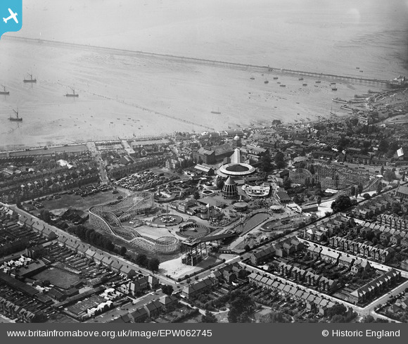
EPW062745 ENGLAND (1939). The Kursaal with Southend Pier in the distance, Southend-on-Sea, 1939
© Copyright OpenStreetMap contributors and licensed by the OpenStreetMap Foundation. 2026. Cartography is licensed as CC BY-SA.
Nearby Images (48)
EPW062745

EPW040987

EPW036612

EPW036726

EPW000444

EPW032920

EAW024659

EAW002192

EPW036615

EPW062743

EPW032919

EPW036616

EPW036978

EPW000443

EPW024869

EPW039864

EPW039862

EPW036730

EPW036977

EAW024660

EPW062747

EPW036617

EPW036981

EPW036980

EPW032924

EPW058223

EPW058224

EPW058226

EPW058443

EPW036614

EPW036976

EPW058225

EPW032925

EPW058446

EPW032921

EAW053086

EPW058447

EPW036995

EPW024890

EPW039861

EAW002194

EPW058222

EAW002219

EPW037003

EPW010871

EAW002191

EAW024661

EPW037016

Details
| Title | [EPW062745] The Kursaal with Southend Pier in the distance, Southend-on-Sea, 1939 |
| Reference | EPW062745 |
| Date | 21-August-1939 |
| Link | |
| Place name | SOUTHEND-ON-SEA |
| Parish | |
| District | |
| Country | ENGLAND |
| Easting / Northing | 589129, 185089 |
| Longitude / Latitude | 0.72713520504788, 51.53250034344 |
| National Grid Reference | TQ891851 |
Pins

southessexmale |
Tuesday 24th of December 2024 12:03:11 AM | |
|
bargee1937 |
Thursday 25th of June 2015 10:48:23 AM | |
|
bargee1937 |
Wednesday 24th of June 2015 07:18:15 PM | |
|
bargee1937 |
Wednesday 24th of June 2015 07:11:44 PM | |
|
bargee1937 |
Wednesday 24th of June 2015 07:08:03 PM | |
|
bargee1937 |
Monday 15th of June 2015 04:27:49 PM | |
|
bargee1937 |
Monday 15th of June 2015 04:21:20 PM | |
|
bargee1937 |
Monday 15th of June 2015 04:04:38 PM | |
|
gBr |
Friday 25th of July 2014 08:15:21 PM |
User Comment Contributions
Under maximum zoom, one can make out 16 of the 19 pleasure boats from Southend that were commandeered for the Dunkirk Evacuation. Missing are the Southend Motor Navigation Co's 75ft TSMV Julia Freak, and the 50ft varnished-hull ML King George, plus Charles and Arthur Myall's 75ft TSMV the 'little' "Britannia I". Their 3 Pitches closest to the Pier are empty. I'm guessing that when this picture was taken, they were operating from the end of the Pier. Interesting to see that by this date, the Burdett Road Jetty, visible in the air photos from 1933, has already been dismantled, the New Royal Sovereign having been sold to a Bridlington owner at the end of the 1935 Season. |
bargee1937 |
Tuesday 9th of June 2015 02:42:21 PM |