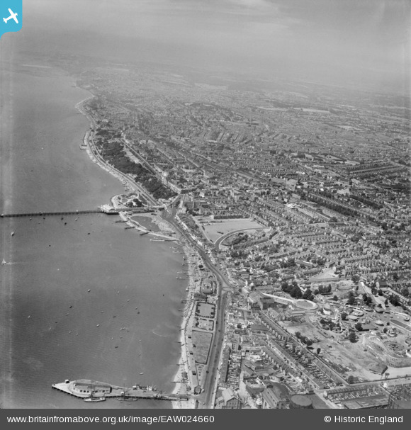
EAW024660 ENGLAND (1949). The waterfront and town from Corporation Landing Pier to The Shrubbery and beyond, Southend-on-Sea, from the east, 1949
© Copyright OpenStreetMap contributors and licensed by the OpenStreetMap Foundation. 2026. Cartography is licensed as CC BY-SA.
Nearby Images (48)
Details
| Title | [EAW024660] The waterfront and town from Corporation Landing Pier to The Shrubbery and beyond, Southend-on-Sea, from the east, 1949 |
| Reference | EAW024660 |
| Date | 11-July-1949 |
| Link | |
| Place name | SOUTHEND-ON-SEA |
| Parish | |
| District | |
| Country | ENGLAND |
| Easting / Northing | 589106, 184968 |
| Longitude / Latitude | 0.7267389801565, 51.531421193678 |
| National Grid Reference | TQ891850 |


![[EAW024660] The waterfront and town from Corporation Landing Pier to The Shrubbery and beyond, Southend-on-Sea, from the east, 1949](http://britainfromabove.org.uk/sites/all/libraries/aerofilms-images/public/100x100/EAW/024/EAW024660.jpg)
![[EAW053086] The seafront and Kursaal looking along Southchurch Avenue, Southend-on-Sea, from the south, 1954](http://britainfromabove.org.uk/sites/all/libraries/aerofilms-images/public/100x100/EAW/053/EAW053086.jpg)
![[EPW000444] Kursaal, Southend-on-Sea, 1920](http://britainfromabove.org.uk/sites/all/libraries/aerofilms-images/public/100x100/EPW/000/EPW000444.jpg)
![[EPW058226] The Kursaal, Southend-on-Sea, from the south-west, 1938](http://britainfromabove.org.uk/sites/all/libraries/aerofilms-images/public/100x100/EPW/058/EPW058226.jpg)
![[EPW036995] The Kursaal, Southchurch Avenue and environs, Southend-on-Sea, from the south-west, 1931](http://britainfromabove.org.uk/sites/all/libraries/aerofilms-images/public/100x100/EPW/036/EPW036995.jpg)
![[EPW037003] The Kursaal and environs, Southend-on-Sea, from the south, 1931](http://britainfromabove.org.uk/sites/all/libraries/aerofilms-images/public/100x100/EPW/037/EPW037003.jpg)
![[EPW036730] The Kursaal Zoo and Amusement Park alongside the Eastern Esplanade and seafront, Southend-on-Sea, 1931](http://britainfromabove.org.uk/sites/all/libraries/aerofilms-images/public/100x100/EPW/036/EPW036730.jpg)
![[EPW024887] The seafront, the Kursaal and the town beyond, Southend-on-Sea, from the south-east, 1928](http://britainfromabove.org.uk/sites/all/libraries/aerofilms-images/public/100x100/EPW/024/EPW024887.jpg)
![[EPW062745] The Kursaal with Southend Pier in the distance, Southend-on-Sea, 1939](http://britainfromabove.org.uk/sites/all/libraries/aerofilms-images/public/100x100/EPW/062/EPW062745.jpg)
![[EPW036726] The Eastern Esplanade, the Kursaal Zoo and Amusement Park and environs, Southend-on-Sea, 1931](http://britainfromabove.org.uk/sites/all/libraries/aerofilms-images/public/100x100/EPW/036/EPW036726.jpg)
![[EPW058224] The Kursaal, Southend-on-Sea, from the south-west, 1938](http://britainfromabove.org.uk/sites/all/libraries/aerofilms-images/public/100x100/EPW/058/EPW058224.jpg)
![[EAW002219] The sea front at Marine Parade, Southend-on-Sea, 1946](http://britainfromabove.org.uk/sites/all/libraries/aerofilms-images/public/100x100/EAW/002/EAW002219.jpg)
![[EPW000443] Kursaal, Southend-on-Sea, 1920](http://britainfromabove.org.uk/sites/all/libraries/aerofilms-images/public/100x100/EPW/000/EPW000443.jpg)
![[EPW058222] The Kursaal, Southend-on-Sea, from the south-west, 1938](http://britainfromabove.org.uk/sites/all/libraries/aerofilms-images/public/100x100/EPW/058/EPW058222.jpg)
![[EPW037004] The Kursaal and environs, Southend-on-Sea, from the south-west, 1931](http://britainfromabove.org.uk/sites/all/libraries/aerofilms-images/public/100x100/EPW/037/EPW037004.jpg)
![[EPW040987] The Kursaal Zoo and Amusement Park, Southend-on-Sea, 1933](http://britainfromabove.org.uk/sites/all/libraries/aerofilms-images/public/100x100/EPW/040/EPW040987.jpg)
![[EPW036612] The Kursaal, Southend-on-Sea, 1931](http://britainfromabove.org.uk/sites/all/libraries/aerofilms-images/public/100x100/EPW/036/EPW036612.jpg)
![[EAW002192] The Kursaal and sea front, Southend-on-Sea, 1946](http://britainfromabove.org.uk/sites/all/libraries/aerofilms-images/public/100x100/EAW/002/EAW002192.jpg)
![[EPW032920] The Kursaal and environs, Southend-on-Sea, 1930](http://britainfromabove.org.uk/sites/all/libraries/aerofilms-images/public/100x100/EPW/032/EPW032920.jpg)
![[EPW036613] The Kursaal, Southend-on-Sea, 1931](http://britainfromabove.org.uk/sites/all/libraries/aerofilms-images/public/100x100/EPW/036/EPW036613.jpg)
![[EPW039865] The Kursaal Zoo and Amusement Park, Southend-on-Sea, 1932](http://britainfromabove.org.uk/sites/all/libraries/aerofilms-images/public/100x100/EPW/039/EPW039865.jpg)
![[EAW024659] The Kursaal and town, Southend-on-Sea, from the east, 1949](http://britainfromabove.org.uk/sites/all/libraries/aerofilms-images/public/100x100/EAW/024/EAW024659.jpg)
![[EPW036615] The Kursaal, Southend-on-Sea, 1931](http://britainfromabove.org.uk/sites/all/libraries/aerofilms-images/public/100x100/EPW/036/EPW036615.jpg)
![[EPW062743] The Kursaal, Southend-on-Sea, 1939. This image has been affected by flare.](http://britainfromabove.org.uk/sites/all/libraries/aerofilms-images/public/100x100/EPW/062/EPW062743.jpg)
![[EPW036982] The Kursaal and environs, Southend-on-Sea, 1931](http://britainfromabove.org.uk/sites/all/libraries/aerofilms-images/public/100x100/EPW/036/EPW036982.jpg)
![[EPW024890] The Kursaal and Marine Parade, Southend-on-Sea, 1928](http://britainfromabove.org.uk/sites/all/libraries/aerofilms-images/public/100x100/EPW/024/EPW024890.jpg)
![[EPW032919] The Kursaal, Southend-on-Sea, 1930](http://britainfromabove.org.uk/sites/all/libraries/aerofilms-images/public/100x100/EPW/032/EPW032919.jpg)
![[EPW036616] The Kursaal, Southend-on-Sea, 1931](http://britainfromabove.org.uk/sites/all/libraries/aerofilms-images/public/100x100/EPW/036/EPW036616.jpg)
![[EPW037016] Marine Parade and environs, Southend-on-Sea, from the south-west, 1931](http://britainfromabove.org.uk/sites/all/libraries/aerofilms-images/public/100x100/EPW/037/EPW037016.jpg)
![[EPW062744] The Kursaal, Southend-on-Sea, 1939](http://britainfromabove.org.uk/sites/all/libraries/aerofilms-images/public/100x100/EPW/062/EPW062744.jpg)
![[EPW040961] The Southend Flat, Marine Parade and the town, Southend-on-Sea, from the south-east, 1933](http://britainfromabove.org.uk/sites/all/libraries/aerofilms-images/public/100x100/EPW/040/EPW040961.jpg)
![[EPW062746] The Kursaal, Southend-on-Sea, 1939](http://britainfromabove.org.uk/sites/all/libraries/aerofilms-images/public/100x100/EPW/062/EPW062746.jpg)
![[EPW024869] The Kursaal, Southend-on-Sea, 1928](http://britainfromabove.org.uk/sites/all/libraries/aerofilms-images/public/100x100/EPW/024/EPW024869.jpg)
![[EPW036978] The Kursaal, Southend-on-Sea, 1931](http://britainfromabove.org.uk/sites/all/libraries/aerofilms-images/public/100x100/EPW/036/EPW036978.jpg)
![[EPW039864] The Kursaal Zoo and Amusement Park, Southend-on-Sea, 1932](http://britainfromabove.org.uk/sites/all/libraries/aerofilms-images/public/100x100/EPW/039/EPW039864.jpg)
![[EPW039862] The Kursaal Zoo and Amusement Park, Southend-on-Sea, 1932. This image has been produced from a damaged negative.](http://britainfromabove.org.uk/sites/all/libraries/aerofilms-images/public/100x100/EPW/039/EPW039862.jpg)
![[EPW062747] The Kursaal, Southend-on-Sea, 1939](http://britainfromabove.org.uk/sites/all/libraries/aerofilms-images/public/100x100/EPW/062/EPW062747.jpg)
![[EPW036977] The Kursaal, Southend-on-Sea, 1931](http://britainfromabove.org.uk/sites/all/libraries/aerofilms-images/public/100x100/EPW/036/EPW036977.jpg)
![[EPW036617] The Kursaal, Southend-on-Sea, 1931](http://britainfromabove.org.uk/sites/all/libraries/aerofilms-images/public/100x100/EPW/036/EPW036617.jpg)
![[EPW036981] The Kursaal, Southend-on-Sea, 1931](http://britainfromabove.org.uk/sites/all/libraries/aerofilms-images/public/100x100/EPW/036/EPW036981.jpg)
![[EPW036980] The Kursaal, Southend-on-Sea, 1931](http://britainfromabove.org.uk/sites/all/libraries/aerofilms-images/public/100x100/EPW/036/EPW036980.jpg)
![[EPW058223] The Kursaal, Southend-on-Sea, 1938](http://britainfromabove.org.uk/sites/all/libraries/aerofilms-images/public/100x100/EPW/058/EPW058223.jpg)
![[EPW058443] The Kursaal, Southend-on-Sea, 1938](http://britainfromabove.org.uk/sites/all/libraries/aerofilms-images/public/100x100/EPW/058/EPW058443.jpg)
![[EPW036976] The Kursaal, Southend-on-Sea, 1931](http://britainfromabove.org.uk/sites/all/libraries/aerofilms-images/public/100x100/EPW/036/EPW036976.jpg)
![[EPW036979] The Kursaal, Southend-on-Sea, 1931](http://britainfromabove.org.uk/sites/all/libraries/aerofilms-images/public/100x100/EPW/036/EPW036979.jpg)
![[EPW032923] The Kursaal, Southend-on-Sea, 1930](http://britainfromabove.org.uk/sites/all/libraries/aerofilms-images/public/100x100/EPW/032/EPW032923.jpg)
![[EPW039866] The Kursaal Zoo and Amusement Park, Southend-on-Sea, 1932](http://britainfromabove.org.uk/sites/all/libraries/aerofilms-images/public/100x100/EPW/039/EPW039866.jpg)
![[EPW010871] Pleasant Road, Southchurch Avenue and the Kursaal, Southend-on-Sea, 1924. This image has been produced from a copy-negative.](http://britainfromabove.org.uk/sites/all/libraries/aerofilms-images/public/100x100/EPW/010/EPW010871.jpg)
