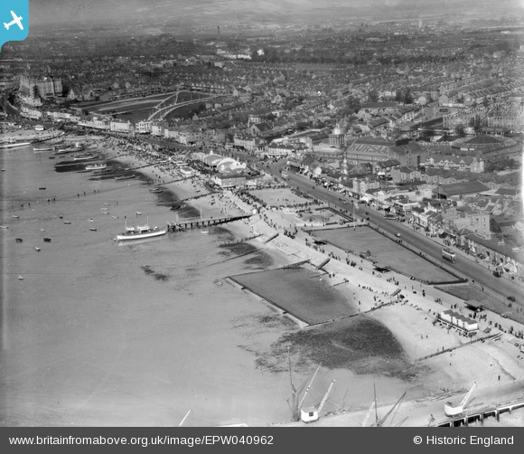
EPW040962 ENGLAND (1933). The Southend Flat, the Eastern Esplanade and the town, Southend-on-Sea, from the south-east, 1933
© Copyright OpenStreetMap contributors and licensed by the OpenStreetMap Foundation. 2026. Cartography is licensed as CC BY-SA.
Nearby Images (13)
Details
| Title | [EPW040962] The Southend Flat, the Eastern Esplanade and the town, Southend-on-Sea, from the south-east, 1933 |
| Reference | EPW040962 |
| Date | April-1933 |
| Link | |
| Place name | SOUTHEND-ON-SEA |
| Parish | |
| District | |
| Country | ENGLAND |
| Easting / Northing | 589255, 184821 |
| Longitude / Latitude | 0.72880580472014, 51.530050876595 |
| National Grid Reference | TQ893848 |
Pins

Sara |
Friday 19th of January 2024 06:08:42 PM | |

bargee1937 |
Saturday 18th of April 2015 11:58:05 PM | |

bargee1937 |
Saturday 18th of April 2015 11:56:01 PM | |

bargee1937 |
Sunday 5th of April 2015 05:19:43 PM | |

bargee1937 |
Sunday 5th of April 2015 05:17:00 PM |


![[EPW040962] The Southend Flat, the Eastern Esplanade and the town, Southend-on-Sea, from the south-east, 1933](http://britainfromabove.org.uk/sites/all/libraries/aerofilms-images/public/100x100/EPW/040/EPW040962.jpg)
![[EPW037004] The Kursaal and environs, Southend-on-Sea, from the south-west, 1931](http://britainfromabove.org.uk/sites/all/libraries/aerofilms-images/public/100x100/EPW/037/EPW037004.jpg)
![[EPW040961] The Southend Flat, Marine Parade and the town, Southend-on-Sea, from the south-east, 1933](http://britainfromabove.org.uk/sites/all/libraries/aerofilms-images/public/100x100/EPW/040/EPW040961.jpg)
![[EPW037003] The Kursaal and environs, Southend-on-Sea, from the south, 1931](http://britainfromabove.org.uk/sites/all/libraries/aerofilms-images/public/100x100/EPW/037/EPW037003.jpg)
![[EPW036736] The Corporation Loading Pier and the Eastern Esplanade Gas Works, Southend-on-Sea, 1931](http://britainfromabove.org.uk/sites/all/libraries/aerofilms-images/public/100x100/EPW/036/EPW036736.jpg)
![[EPW024887] The seafront, the Kursaal and the town beyond, Southend-on-Sea, from the south-east, 1928](http://britainfromabove.org.uk/sites/all/libraries/aerofilms-images/public/100x100/EPW/024/EPW024887.jpg)
![[EPW040965] The Corporation Loading Pier, the Eastern Esplanade and the town, Southend-on-Sea, from the south-east, 1933](http://britainfromabove.org.uk/sites/all/libraries/aerofilms-images/public/100x100/EPW/040/EPW040965.jpg)
![[EAW024660] The waterfront and town from Corporation Landing Pier to The Shrubbery and beyond, Southend-on-Sea, from the east, 1949](http://britainfromabove.org.uk/sites/all/libraries/aerofilms-images/public/100x100/EAW/024/EAW024660.jpg)
![[EPW000444] Kursaal, Southend-on-Sea, 1920](http://britainfromabove.org.uk/sites/all/libraries/aerofilms-images/public/100x100/EPW/000/EPW000444.jpg)
![[EAW053086] The seafront and Kursaal looking along Southchurch Avenue, Southend-on-Sea, from the south, 1954](http://britainfromabove.org.uk/sites/all/libraries/aerofilms-images/public/100x100/EAW/053/EAW053086.jpg)
![[EPW036995] The Kursaal, Southchurch Avenue and environs, Southend-on-Sea, from the south-west, 1931](http://britainfromabove.org.uk/sites/all/libraries/aerofilms-images/public/100x100/EPW/036/EPW036995.jpg)
![[EPW058226] The Kursaal, Southend-on-Sea, from the south-west, 1938](http://britainfromabove.org.uk/sites/all/libraries/aerofilms-images/public/100x100/EPW/058/EPW058226.jpg)
![[EPW036730] The Kursaal Zoo and Amusement Park alongside the Eastern Esplanade and seafront, Southend-on-Sea, 1931](http://britainfromabove.org.uk/sites/all/libraries/aerofilms-images/public/100x100/EPW/036/EPW036730.jpg)
