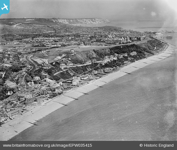
EPW035415 ENGLAND (1931). Sandgate Castle, Radnor Cliff and the town of Folkestone, Sandgate, from the south-west, 1931
© Copyright OpenStreetMap contributors and licensed by the OpenStreetMap Foundation. 2026. Cartography is licensed as CC BY-SA.
Nearby Images (11)
Details
| Title | [EPW035415] Sandgate Castle, Radnor Cliff and the town of Folkestone, Sandgate, from the south-west, 1931 |
| Reference | EPW035415 |
| Date | 25-May-1931 |
| Link | |
| Place name | SANDGATE |
| Parish | SANDGATE |
| District | |
| Country | ENGLAND |
| Easting / Northing | 620786, 135126 |
| Longitude / Latitude | 1.1520044500123, 51.072389629661 |
| National Grid Reference | TR208351 |
Pins

Sara |
Wednesday 8th of March 2023 06:51:03 PM | |

Rubyruby |
Thursday 15th of August 2019 08:58:20 AM | |

Malcolm |
Monday 3rd of December 2018 02:32:26 PM | |

Malcolm |
Monday 3rd of December 2018 02:31:20 PM | |

Malcolm |
Monday 3rd of December 2018 02:30:31 PM | |

Paolo |
Saturday 15th of December 2012 05:14:49 PM |


![[EPW035415] Sandgate Castle, Radnor Cliff and the town of Folkestone, Sandgate, from the south-west, 1931](http://britainfromabove.org.uk/sites/all/libraries/aerofilms-images/public/100x100/EPW/035/EPW035415.jpg)
![[EAW033166] Sandgate Castle, Sandgate, 1950](http://britainfromabove.org.uk/sites/all/libraries/aerofilms-images/public/100x100/EAW/033/EAW033166.jpg)
![[EPW026115] Sandgate Castle and Sandgate High Street, Sandgate, 1929](http://britainfromabove.org.uk/sites/all/libraries/aerofilms-images/public/100x100/EPW/026/EPW026115.jpg)
![[EPW000649] Sandgate Castle, Sandgate, 1920](http://britainfromabove.org.uk/sites/all/libraries/aerofilms-images/public/100x100/EPW/000/EPW000649.jpg)
![[EPW026119] Sandgate Castle and the village, Sandgate, 1929](http://britainfromabove.org.uk/sites/all/libraries/aerofilms-images/public/100x100/EPW/026/EPW026119.jpg)
![[EAW033165] Sandgate Castle, Sandgate, 1950](http://britainfromabove.org.uk/sites/all/libraries/aerofilms-images/public/100x100/EAW/033/EAW033165.jpg)
![[EPW000146] Castle Road, Sandgate, 1920](http://britainfromabove.org.uk/sites/all/libraries/aerofilms-images/public/100x100/EPW/000/EPW000146.jpg)
![[EPW026117] The village and seafront, Sandgate, 1929](http://britainfromabove.org.uk/sites/all/libraries/aerofilms-images/public/100x100/EPW/026/EPW026117.jpg)
![[EAW024823] The sea front including Sandgate Fort, Sandgate, 1949](http://britainfromabove.org.uk/sites/all/libraries/aerofilms-images/public/100x100/EAW/024/EAW024823.jpg)
![[EAW002858] The village and the seafront, Sandgate, 1946](http://britainfromabove.org.uk/sites/all/libraries/aerofilms-images/public/100x100/EAW/002/EAW002858.jpg)
![[EPW000585] Hotel Metropole, Coolinge, from the west, 1920](http://britainfromabove.org.uk/sites/all/libraries/aerofilms-images/public/100x100/EPW/000/EPW000585.jpg)