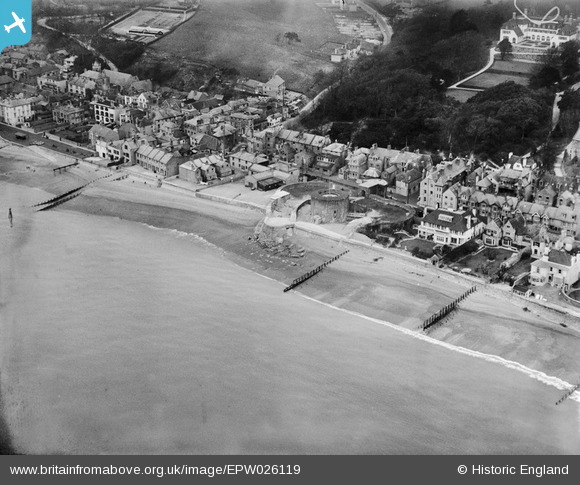
EPW026119 ENGLAND (1929). Sandgate Castle and the village, Sandgate, 1929
© Copyright OpenStreetMap contributors and licensed by the OpenStreetMap Foundation. 2026. Cartography is licensed as CC BY-SA.
Nearby Images (10)
Details
| Title | [EPW026119] Sandgate Castle and the village, Sandgate, 1929 |
| Reference | EPW026119 |
| Date | April-1929 |
| Link | |
| Place name | SANDGATE |
| Parish | SANDGATE |
| District | |
| Country | ENGLAND |
| Easting / Northing | 620676, 135157 |
| Longitude / Latitude | 1.1504555202119, 51.072710300789 |
| National Grid Reference | TR207352 |
Pins
User Comment Contributions
A general point. This is indeed of Sandgate, as are several other photos. If one puts Folkestone into your general search, photos of Folkestone come up. But if you put Sandgate into the search, we are told you have no photos of that description. In fact, you have quite a lot! So it would be good to add Sandgate to the search terms recognised. |

Nicholas Reed |
Sunday 5th of January 2014 09:57:06 PM |


![[EPW026119] Sandgate Castle and the village, Sandgate, 1929](http://britainfromabove.org.uk/sites/all/libraries/aerofilms-images/public/100x100/EPW/026/EPW026119.jpg)
![[EPW026115] Sandgate Castle and Sandgate High Street, Sandgate, 1929](http://britainfromabove.org.uk/sites/all/libraries/aerofilms-images/public/100x100/EPW/026/EPW026115.jpg)
![[EAW033165] Sandgate Castle, Sandgate, 1950](http://britainfromabove.org.uk/sites/all/libraries/aerofilms-images/public/100x100/EAW/033/EAW033165.jpg)
![[EPW000649] Sandgate Castle, Sandgate, 1920](http://britainfromabove.org.uk/sites/all/libraries/aerofilms-images/public/100x100/EPW/000/EPW000649.jpg)
![[EAW033166] Sandgate Castle, Sandgate, 1950](http://britainfromabove.org.uk/sites/all/libraries/aerofilms-images/public/100x100/EAW/033/EAW033166.jpg)
![[EAW024823] The sea front including Sandgate Fort, Sandgate, 1949](http://britainfromabove.org.uk/sites/all/libraries/aerofilms-images/public/100x100/EAW/024/EAW024823.jpg)
![[EPW035415] Sandgate Castle, Radnor Cliff and the town of Folkestone, Sandgate, from the south-west, 1931](http://britainfromabove.org.uk/sites/all/libraries/aerofilms-images/public/100x100/EPW/035/EPW035415.jpg)
![[EPW000146] Castle Road, Sandgate, 1920](http://britainfromabove.org.uk/sites/all/libraries/aerofilms-images/public/100x100/EPW/000/EPW000146.jpg)
![[EAW024824] The sea front, Sandgate, from the south-west, 1949](http://britainfromabove.org.uk/sites/all/libraries/aerofilms-images/public/100x100/EAW/024/EAW024824.jpg)
![[EPW000145] Granville Parade, Sandgate, 1920](http://britainfromabove.org.uk/sites/all/libraries/aerofilms-images/public/100x100/EPW/000/EPW000145.jpg)