
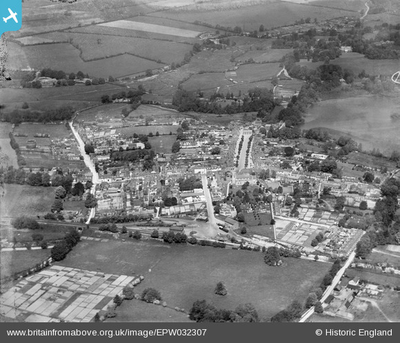
EPW032307 ENGLAND (1930). The town, Old Alresford Pond and Old Alresford Park, New Alresford, 1930
© Copyright OpenStreetMap contributors and licensed by the OpenStreetMap Foundation. 2026. Cartography is licensed as CC BY-SA.
Nearby Images (10)
EPW032307

EPW023309

EPW023313

EPW032308

EPW023310

EPW023311

EPW023314

EPW032306

EPW023315

EAW040902

Details
| Title | [EPW032307] The town, Old Alresford Pond and Old Alresford Park, New Alresford, 1930 |
| Reference | EPW032307 |
| Date | June-1930 |
| Link | |
| Place name | NEW ALRESFORD |
| Parish | NEW ALRESFORD |
| District | |
| Country | ENGLAND |
| Easting / Northing | 458756, 132707 |
| Longitude / Latitude | -1.1609440530148, 51.090131507996 |
| National Grid Reference | SU588327 |
Pins

RLL |
Tuesday 8th of January 2019 05:47:09 PM | |
|
RLL |
Tuesday 8th of January 2019 05:46:37 PM | |
|
RLL |
Tuesday 8th of January 2019 05:43:52 PM | |
|
RLL |
Tuesday 8th of January 2019 05:42:11 PM | |
|
RLL |
Tuesday 8th of January 2019 05:41:14 PM | |
|
RLL |
Tuesday 8th of January 2019 05:39:57 PM | |
|
RLL |
Tuesday 8th of January 2019 05:38:59 PM | |
|
raglanite |
Sunday 4th of May 2014 11:52:47 AM | |
|
raglanite |
Sunday 4th of May 2014 11:51:36 AM | |
|
raglanite |
Sunday 4th of May 2014 11:49:44 AM | |
|
raglanite |
Sunday 4th of May 2014 11:46:28 AM | |
|
raglanite |
Sunday 4th of May 2014 11:45:11 AM | |
|
raglanite |
Sunday 4th of May 2014 11:44:33 AM | |
|
raglanite |
Sunday 4th of May 2014 11:43:39 AM | |
|
raglanite |
Sunday 4th of May 2014 11:42:57 AM |