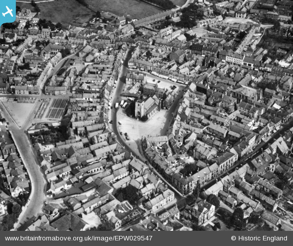
EPW029547 ENGLAND (1929). St Michael's Church and the town centre, Malton, 1929. This image has been produced from a copy-negative.
    © Copyright OpenStreetMap contributors and licensed by the OpenStreetMap Foundation. 2025. Cartography is licensed as CC BY-SA.
  
Nearby Images (6)
Details
| Title | [EPW029547] St Michael's Church and the town centre, Malton, 1929. This image has been produced from a copy-negative. | 
| Reference | EPW029547 | 
| Date | October-1929 | 
| Link | |
| Place name | MALTON | 
| Parish | MALTON | 
| District | |
| Country | ENGLAND | 
| Easting / Northing | 478556, 471704 | 
| Longitude / Latitude | -0.79754131193345, 54.134992986809 | 
| National Grid Reference | SE786717 | 
 
             
  ![[EPW029547] St Michael's Church and the town centre, Malton, 1929. This image has been produced from a copy-negative.](http://britainfromabove.org.uk/sites/all/libraries/aerofilms-images/public/100x100/EPW/029/EPW029547.jpg) 
  
                                          ![[EPW029548] The town centre, Malton, 1929. This image has been produced from a copy-negative.](http://britainfromabove.org.uk/sites/all/libraries/aerofilms-images/public/100x100/EPW/029/EPW029548.jpg) 
 ![[EPW029544] The town, Malton, 1929. This image has been produced from a copy-negative.](http://britainfromabove.org.uk/sites/all/libraries/aerofilms-images/public/100x100/EPW/029/EPW029544.jpg) 
 ![[EPW048560] The town, Malton, 1935](http://britainfromabove.org.uk/sites/all/libraries/aerofilms-images/public/100x100/EPW/048/EPW048560.jpg) 
 ![[EPW048549] The town and surrounding countryside, Malton, from the south-west, 1935](http://britainfromabove.org.uk/sites/all/libraries/aerofilms-images/public/100x100/EPW/048/EPW048549.jpg) 
 ![[EPW048559] The Cattle Market, Town Hall and Newbiggin, Malton, 1935](http://britainfromabove.org.uk/sites/all/libraries/aerofilms-images/public/100x100/EPW/048/EPW048559.jpg) 
  Wentworth Car Park with Showfield lane just above
 Wentworth Car Park with Showfield lane just above