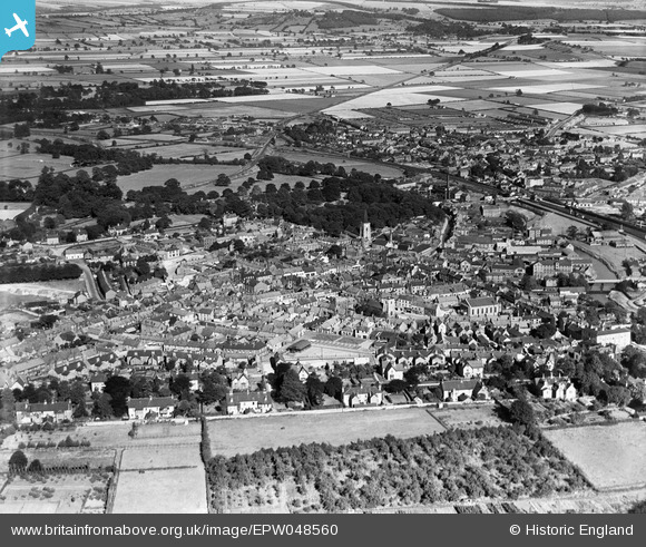
EPW048560 ENGLAND (1935). The town, Malton, 1935
© Copyright OpenStreetMap contributors and licensed by the OpenStreetMap Foundation. 2026. Cartography is licensed as CC BY-SA.
Nearby Images (11)
Details
| Title | [EPW048560] The town, Malton, 1935 |
| Reference | EPW048560 |
| Date | July-1935 |
| Link | |
| Place name | MALTON |
| Parish | MALTON |
| District | |
| Country | ENGLAND |
| Easting / Northing | 478767, 471728 |
| Longitude / Latitude | -0.794306054374, 54.135176365789 |
| National Grid Reference | SE788717 |
Pins
Be the first to add a comment to this image!


![[EPW048560] The town, Malton, 1935](http://britainfromabove.org.uk/sites/all/libraries/aerofilms-images/public/100x100/EPW/048/EPW048560.jpg)
![[EPW048546] St Leonard's Church and the town, Malton, 1935](http://britainfromabove.org.uk/sites/all/libraries/aerofilms-images/public/100x100/EPW/048/EPW048546.jpg)
![[EPW029544] The town, Malton, 1929. This image has been produced from a copy-negative.](http://britainfromabove.org.uk/sites/all/libraries/aerofilms-images/public/100x100/EPW/029/EPW029544.jpg)
![[EPW029546] The town, Malton, 1929. This image has been produced from a copy-negative.](http://britainfromabove.org.uk/sites/all/libraries/aerofilms-images/public/100x100/EPW/029/EPW029546.jpg)
![[EPW048537] The town and surrounding countryside, Malton, from the south-west, 1935](http://britainfromabove.org.uk/sites/all/libraries/aerofilms-images/public/100x100/EPW/048/EPW048537.jpg)
![[EPW029548] The town centre, Malton, 1929. This image has been produced from a copy-negative.](http://britainfromabove.org.uk/sites/all/libraries/aerofilms-images/public/100x100/EPW/029/EPW029548.jpg)
![[EPW048576] The Lodge and the site of Malton Castle, Malton, 1935](http://britainfromabove.org.uk/sites/all/libraries/aerofilms-images/public/100x100/EPW/048/EPW048576.jpg)
![[EPW029547] St Michael's Church and the town centre, Malton, 1929. This image has been produced from a copy-negative.](http://britainfromabove.org.uk/sites/all/libraries/aerofilms-images/public/100x100/EPW/029/EPW029547.jpg)
![[EPW048577] Malton Bridge, the site of Malton Castle and St Leonard's Church, Malton, 1935](http://britainfromabove.org.uk/sites/all/libraries/aerofilms-images/public/100x100/EPW/048/EPW048577.jpg)
![[EPW048574] St Leonard's Church, the site of Malton Castle and Orchard Field, Malton, 1935](http://britainfromabove.org.uk/sites/all/libraries/aerofilms-images/public/100x100/EPW/048/EPW048574.jpg)
![[EPW048554] The town Gas Works, the site of Malton Castle and the town, Malton, 1935](http://britainfromabove.org.uk/sites/all/libraries/aerofilms-images/public/100x100/EPW/048/EPW048554.jpg)