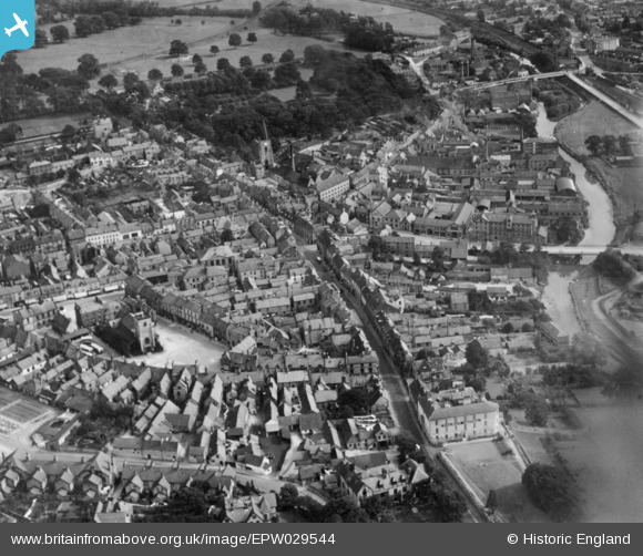
EPW029544 ENGLAND (1929). The town, Malton, 1929. This image has been produced from a copy-negative.
© Copyright OpenStreetMap contributors and licensed by the OpenStreetMap Foundation. 2026. Cartography is licensed as CC BY-SA.
Nearby Images (8)
Details
| Title | [EPW029544] The town, Malton, 1929. This image has been produced from a copy-negative. |
| Reference | EPW029544 |
| Date | September-1929 |
| Link | |
| Place name | MALTON |
| Parish | MALTON |
| District | |
| Country | ENGLAND |
| Easting / Northing | 478680, 471632 |
| Longitude / Latitude | -0.79566247548707, 54.134326987337 |
| National Grid Reference | SE787716 |
Pins

MB |
Friday 7th of October 2016 05:41:08 PM | |

4wd |
Thursday 24th of March 2016 11:28:16 AM | |

Mortimer |
Wednesday 19th of August 2015 02:24:10 PM | |

Mortimer |
Wednesday 19th of August 2015 02:23:30 PM | |

Mortimer |
Wednesday 19th of August 2015 02:22:29 PM | |

Mortimer |
Wednesday 19th of August 2015 02:22:03 PM | |

Mortimer |
Wednesday 19th of August 2015 02:19:58 PM | |

Mortimer |
Wednesday 19th of August 2015 02:19:02 PM | |

Mortimer |
Wednesday 19th of August 2015 02:18:21 PM | |

Mortimer |
Wednesday 19th of August 2015 02:17:46 PM | |

Mortimer |
Wednesday 19th of August 2015 02:15:01 PM | |

Mortimer |
Wednesday 19th of August 2015 02:13:45 PM | |

Mortimer |
Wednesday 19th of August 2015 02:10:40 PM |


![[EPW029544] The town, Malton, 1929. This image has been produced from a copy-negative.](http://britainfromabove.org.uk/sites/all/libraries/aerofilms-images/public/100x100/EPW/029/EPW029544.jpg)
![[EPW048560] The town, Malton, 1935](http://britainfromabove.org.uk/sites/all/libraries/aerofilms-images/public/100x100/EPW/048/EPW048560.jpg)
![[EPW029547] St Michael's Church and the town centre, Malton, 1929. This image has been produced from a copy-negative.](http://britainfromabove.org.uk/sites/all/libraries/aerofilms-images/public/100x100/EPW/029/EPW029547.jpg)
![[EPW048546] St Leonard's Church and the town, Malton, 1935](http://britainfromabove.org.uk/sites/all/libraries/aerofilms-images/public/100x100/EPW/048/EPW048546.jpg)
![[EPW029546] The town, Malton, 1929. This image has been produced from a copy-negative.](http://britainfromabove.org.uk/sites/all/libraries/aerofilms-images/public/100x100/EPW/029/EPW029546.jpg)
![[EPW029548] The town centre, Malton, 1929. This image has been produced from a copy-negative.](http://britainfromabove.org.uk/sites/all/libraries/aerofilms-images/public/100x100/EPW/029/EPW029548.jpg)
![[EPW048561] Malton Railway Station, the town and surrounding countryside, Norton-on-Derwent, from the south, 1935](http://britainfromabove.org.uk/sites/all/libraries/aerofilms-images/public/100x100/EPW/048/EPW048561.jpg)
![[EPW048537] The town and surrounding countryside, Malton, from the south-west, 1935](http://britainfromabove.org.uk/sites/all/libraries/aerofilms-images/public/100x100/EPW/048/EPW048537.jpg)