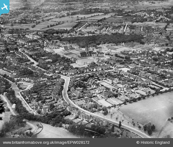
EPW028172 ENGLAND (1929). St Jude's Church and environs, Hampstead Garden Suburb, 1929
© Copyright OpenStreetMap contributors and licensed by the OpenStreetMap Foundation. 2025. Cartography is licensed as CC BY-SA.
Nearby Images (15)
Details
| Title | [EPW028172] St Jude's Church and environs, Hampstead Garden Suburb, 1929 |
| Reference | EPW028172 |
| Date | July-1929 |
| Link | |
| Place name | HAMPSTEAD GARDEN SUBURB |
| Parish | |
| District | |
| Country | ENGLAND |
| Easting / Northing | 525519, 188204 |
| Longitude / Latitude | -0.18835556282225, 51.578230348482 |
| National Grid Reference | TQ255882 |
Pins
Be the first to add a comment to this image!


![[EPW028172] St Jude's Church and environs, Hampstead Garden Suburb, 1929](http://britainfromabove.org.uk/sites/all/libraries/aerofilms-images/public/100x100/EPW/028/EPW028172.jpg)
![[EPW028985] Central Square, Big Wood and environs, Hampstead Garden Suburb, 1929. This image has been produced from a print.](http://britainfromabove.org.uk/sites/all/libraries/aerofilms-images/public/100x100/EPW/028/EPW028985.jpg)
![[EPW028984] Heathgate, Central Square and environs, Hampstead Garden Suburb, 1929. This image has been produced from a print affected by flare.](http://britainfromabove.org.uk/sites/all/libraries/aerofilms-images/public/100x100/EPW/028/EPW028984.jpg)
![[EPW047876] Central Square and Southway, Hampstead Garden Suburb, 1935. This image has been produced from a copy-negative.](http://britainfromabove.org.uk/sites/all/libraries/aerofilms-images/public/100x100/EPW/047/EPW047876.jpg)
![[EPW028986] Central Square and environs, Hampstead Garden Suburb, 1929. This image has been produced from a copy-negative.](http://britainfromabove.org.uk/sites/all/libraries/aerofilms-images/public/100x100/EPW/028/EPW028986.jpg)
![[EPW028983] Central Square, Big Wood and environs, Hampstead Garden Suburb, 1929. This image has been produced from a print.](http://britainfromabove.org.uk/sites/all/libraries/aerofilms-images/public/100x100/EPW/028/EPW028983.jpg)
![[EPW009091] St Jude's Church and environs, Hampstead Garden Suburb, 1923](http://britainfromabove.org.uk/sites/all/libraries/aerofilms-images/public/100x100/EPW/009/EPW009091.jpg)
![[EPW028175] Turner Drive and environs, Hampstead Garden Suburb, 1929](http://britainfromabove.org.uk/sites/all/libraries/aerofilms-images/public/100x100/EPW/028/EPW028175.jpg)
![[EPW028173] St Jude's Church and environs, Hampstead Garden Suburb, 1929](http://britainfromabove.org.uk/sites/all/libraries/aerofilms-images/public/100x100/EPW/028/EPW028173.jpg)
![[EPW028977] Central Square and environs, Hampstead Garden Suburb, 1929. This image has been produced from a copy-negative.](http://britainfromabove.org.uk/sites/all/libraries/aerofilms-images/public/100x100/EPW/028/EPW028977.jpg)
![[EPW047880] Hoop Lane Jewish Cemetery and environs, Golders Green, 1935](http://britainfromabove.org.uk/sites/all/libraries/aerofilms-images/public/100x100/EPW/047/EPW047880.jpg)
![[EAW046479] Central Square, Big Wood and environs, Hampstead Garden Suburb, 1952](http://britainfromabove.org.uk/sites/all/libraries/aerofilms-images/public/100x100/EAW/046/EAW046479.jpg)
![[EPW047874] Central Square and the view up Middleway, Hampstead Garden Suburb, from the south-west, 1935](http://britainfromabove.org.uk/sites/all/libraries/aerofilms-images/public/100x100/EPW/047/EPW047874.jpg)
![[EPW028186] Golders Green Crematorium, Golders Green, 1929](http://britainfromabove.org.uk/sites/all/libraries/aerofilms-images/public/100x100/EPW/028/EPW028186.jpg)
![[EPW028187] Golders Green Crematorium, Golders Green, 1929](http://britainfromabove.org.uk/sites/all/libraries/aerofilms-images/public/100x100/EPW/028/EPW028187.jpg)