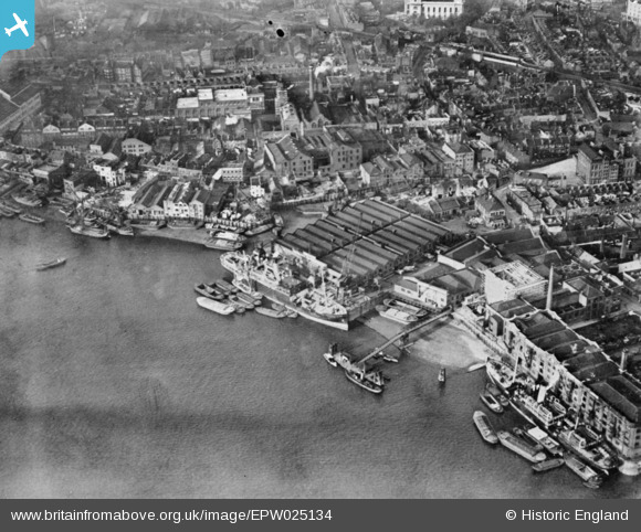
EPW025134 ENGLAND (1928). Limekiln Dock and surrounding warehouses, Limehouse, 1928. This image has been produced from a copy-negative.
© Copyright OpenStreetMap contributors and licensed by the OpenStreetMap Foundation. 2026. Cartography is licensed as CC BY-SA.
Nearby Images (19)
Details
| Title | [EPW025134] Limekiln Dock and surrounding warehouses, Limehouse, 1928. This image has been produced from a copy-negative. |
| Reference | EPW025134 |
| Date | 23-October-1928 |
| Link | |
| Place name | LIMEHOUSE |
| Parish | |
| District | |
| Country | ENGLAND |
| Easting / Northing | 536743, 180602 |
| Longitude / Latitude | -0.029410357558912, 51.507298842947 |
| National Grid Reference | TQ367806 |
Pins

Grollo |
Monday 23rd of October 2023 04:16:41 PM | |

Grollo |
Monday 23rd of October 2023 04:15:27 PM | |

moses72 |
Monday 2nd of November 2015 11:09:11 AM | |

moses72 |
Monday 2nd of November 2015 11:04:46 AM | |

moses72 |
Monday 2nd of November 2015 10:59:18 AM | |

moses72 |
Monday 2nd of November 2015 10:42:28 AM | |

Class31 |
Monday 30th of March 2015 08:10:24 AM |


![[EPW025134] Limekiln Dock and surrounding warehouses, Limehouse, 1928. This image has been produced from a copy-negative.](http://britainfromabove.org.uk/sites/all/libraries/aerofilms-images/public/100x100/EPW/025/EPW025134.jpg)
![[EAW048410] The SS Angusburn moored at Dundee Wharf, Limehouse, 1953. This image was marked by Aerofilms Ltd for photo editing.](http://britainfromabove.org.uk/sites/all/libraries/aerofilms-images/public/100x100/EAW/048/EAW048410.jpg)
![[EAW048417] The SS Angusburn moored at Dundee Wharf, Limehouse, 1953. This image was marked by Aerofilms Ltd for photo editing.](http://britainfromabove.org.uk/sites/all/libraries/aerofilms-images/public/100x100/EAW/048/EAW048417.jpg)
![[EAW048416] The SS Angusburn moored at Dundee Wharf, Limehouse, 1953. This image was marked by Aerofilms Ltd for photo editing.](http://britainfromabove.org.uk/sites/all/libraries/aerofilms-images/public/100x100/EAW/048/EAW048416.jpg)
![[EAW048420] Dundee Wharf, Limehouse, 1953. This image was marked by Aerofilms Ltd for photo editing.](http://britainfromabove.org.uk/sites/all/libraries/aerofilms-images/public/100x100/EAW/048/EAW048420.jpg)
![[EAW048413] Dundee Wharf, Limehouse, 1953. This image was marked by Aerofilms Ltd for photo editing.](http://britainfromabove.org.uk/sites/all/libraries/aerofilms-images/public/100x100/EAW/048/EAW048413.jpg)
![[EPW025135] Limekiln Dock and surrounding warehouses, Limehouse, 1928. This image has been produced from a print.](http://britainfromabove.org.uk/sites/all/libraries/aerofilms-images/public/100x100/EPW/025/EPW025135.jpg)
![[EAW048411] The SS Angusburn moored at Dundee Wharf, Limehouse, 1953. This image was marked by Aerofilms Ltd for photo editing.](http://britainfromabove.org.uk/sites/all/libraries/aerofilms-images/public/100x100/EAW/048/EAW048411.jpg)
![[EAW048415] The SS Angusburn moored at Dundee Wharf, Limehouse, 1953. This image was marked by Aerofilms Ltd for photo editing.](http://britainfromabove.org.uk/sites/all/libraries/aerofilms-images/public/100x100/EAW/048/EAW048415.jpg)
![[EAW048412] The SS Angusburn moored at Dundee Wharf, Limehouse, 1953. This image was marked by Aerofilms Ltd for photo editing.](http://britainfromabove.org.uk/sites/all/libraries/aerofilms-images/public/100x100/EAW/048/EAW048412.jpg)
![[EAW048419] The SS Angusburn moored at Dundee Wharf, Limehouse, 1953. This image was marked by Aerofilms Ltd for photo editing.](http://britainfromabove.org.uk/sites/all/libraries/aerofilms-images/public/100x100/EAW/048/EAW048419.jpg)
![[EAW048418] The SS Angusburn moored at Dundee Wharf, Limehouse, 1953. This image was marked by Aerofilms Ltd for photo editing.](http://britainfromabove.org.uk/sites/all/libraries/aerofilms-images/public/100x100/EAW/048/EAW048418.jpg)
![[EAW048414] The SS Angusburn moored at Dundee Wharf, Limehouse, 1953. This image was marked by Aerofilms Ltd for photo editing.](http://britainfromabove.org.uk/sites/all/libraries/aerofilms-images/public/100x100/EAW/048/EAW048414.jpg)
![[EPW060798] Surrey Commercial Docks, the Isle of Dogs and environs, Limehouse, 1939](http://britainfromabove.org.uk/sites/all/libraries/aerofilms-images/public/100x100/EPW/060/EPW060798.jpg)
![[EPW010938] The River Thames alongside Ratcliff and Limehouse, Poplar, 1924. This image has been produced from a damaged print.](http://britainfromabove.org.uk/sites/all/libraries/aerofilms-images/public/100x100/EPW/010/EPW010938.jpg)