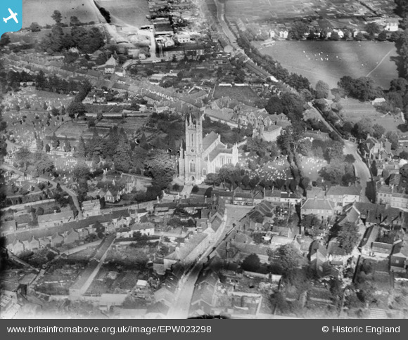
EPW023298 ENGLAND (1928). St Mary's Church and environs, Andover, 1928
© Copyright OpenStreetMap contributors and licensed by the OpenStreetMap Foundation. 2026. Cartography is licensed as CC BY-SA.
Nearby Images (9)
Details
| Title | [EPW023298] St Mary's Church and environs, Andover, 1928 |
| Reference | EPW023298 |
| Date | September-1928 |
| Link | |
| Place name | ANDOVER |
| Parish | ANDOVER |
| District | |
| Country | ENGLAND |
| Easting / Northing | 436508, 145778 |
| Longitude / Latitude | -1.4773086037321, 51.209523016444 |
| National Grid Reference | SU365458 |


![[EPW023298] St Mary's Church and environs, Andover, 1928](http://britainfromabove.org.uk/sites/all/libraries/aerofilms-images/public/100x100/EPW/023/EPW023298.jpg)
![[EPW023295] St Mary's Church and environs, Andover, 1928](http://britainfromabove.org.uk/sites/all/libraries/aerofilms-images/public/100x100/EPW/023/EPW023295.jpg)
![[EPW022738] St Mary's Church, Andover, 1928](http://britainfromabove.org.uk/sites/all/libraries/aerofilms-images/public/100x100/EPW/022/EPW022738.jpg)
![[EPW022745] St Mary's Church, Andover, 1928. This image has been produced from a copy-negative.](http://britainfromabove.org.uk/sites/all/libraries/aerofilms-images/public/100x100/EPW/022/EPW022745.jpg)
![[EPW022736] St Mary's Church, Andover, 1928](http://britainfromabove.org.uk/sites/all/libraries/aerofilms-images/public/100x100/EPW/022/EPW022736.jpg)
![[EPW011129] St Mary's Church and Marlborough Street, Andover, 1924](http://britainfromabove.org.uk/sites/all/libraries/aerofilms-images/public/100x100/EPW/011/EPW011129.jpg)
![[EPW023297] St Mary's Church and environs, Andover, 1928](http://britainfromabove.org.uk/sites/all/libraries/aerofilms-images/public/100x100/EPW/023/EPW023297.jpg)
![[EPW011128] St Mary's Church and Marlborough Street, Andover, 1924](http://britainfromabove.org.uk/sites/all/libraries/aerofilms-images/public/100x100/EPW/011/EPW011128.jpg)
![[EPW011123] The Town Hall and environs, Andover, 1924](http://britainfromabove.org.uk/sites/all/libraries/aerofilms-images/public/100x100/EPW/011/EPW011123.jpg)
