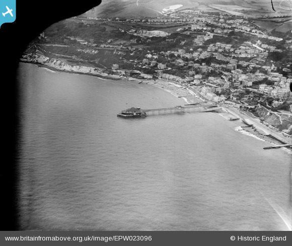
EPW023096 ENGLAND (1928). The Royal Victoria Pier and Ventnor Bay, Ventnor, 1928
    © Copyright OpenStreetMap contributors and licensed by the OpenStreetMap Foundation. 2025. Cartography is licensed as CC BY-SA.
  
Nearby Images (22)
Details
| Title | [EPW023096] The Royal Victoria Pier and Ventnor Bay, Ventnor, 1928 | 
| Reference | EPW023096 | 
| Date | August-1928 | 
| Link | |
| Place name | VENTNOR | 
| Parish | VENTNOR | 
| District | |
| Country | ENGLAND | 
| Easting / Northing | 456342, 77185 | 
| Longitude / Latitude | -1.2039544082929, 50.591084196504 | 
| National Grid Reference | SZ563772 | 
Pins
|  Ventnor West station, closed 1952. |   John W | Friday 31st of March 2017 06:47:46 PM | 
|  The pier is intact here. There is no record of when the collapse happened but after the Second World War the pier was not repaired and re-opened until 1953 |   Billy Turner | Tuesday 8th of March 2016 04:18:37 PM | 
 
             
  ![[EPW023096] The Royal Victoria Pier and Ventnor Bay, Ventnor, 1928](http://britainfromabove.org.uk/sites/all/libraries/aerofilms-images/public/100x100/EPW/023/EPW023096.jpg) 
  
                                          ![[EAW022210] Royal Victoria Pier and the town, Ventnor, from the south-east, 1949](http://britainfromabove.org.uk/sites/all/libraries/aerofilms-images/public/100x100/EAW/022/EAW022210.jpg) 
 ![[EPW023097] The Royal Victoria Pier and Ventnor Bay, Ventnor, 1928](http://britainfromabove.org.uk/sites/all/libraries/aerofilms-images/public/100x100/EPW/023/EPW023097.jpg) 
 ![[EAW022208] Royal Victoria Pier and the Esplanade, Ventnor, from the south-east, 1949](http://britainfromabove.org.uk/sites/all/libraries/aerofilms-images/public/100x100/EAW/022/EAW022208.jpg) 
 ![[EAW038594] Mill Cove, Royal Victoria Pier and Ventnor Bay, Ventnor, 1951. This image has been produced from a print.](http://britainfromabove.org.uk/sites/all/libraries/aerofilms-images/public/100x100/EAW/038/EAW038594.jpg) 
 ![[EAW015243] The Royal Victoria Pier, Ventnor Bay and the town, Ventnor, 1948](http://britainfromabove.org.uk/sites/all/libraries/aerofilms-images/public/100x100/EAW/015/EAW015243.jpg) 
 ![[EPW039656] Ventnor Bay and the pier, Ventnor, 1932](http://britainfromabove.org.uk/sites/all/libraries/aerofilms-images/public/100x100/EPW/039/EPW039656.jpg) 
 ![[EAW022209] Royal Victoria Pier, Ventnor Radar Station and the town, Ventnor, from the south, 1949](http://britainfromabove.org.uk/sites/all/libraries/aerofilms-images/public/100x100/EAW/022/EAW022209.jpg) 
 ![[EPW023099] Ventnor Bay and the Esplanade, Ventnor, 1928](http://britainfromabove.org.uk/sites/all/libraries/aerofilms-images/public/100x100/EPW/023/EPW023099.jpg) 
 ![[EAW022207] Royal Victoria Pier and the town, Ventnor, from the south, 1949](http://britainfromabove.org.uk/sites/all/libraries/aerofilms-images/public/100x100/EAW/022/EAW022207.jpg) 
 ![[EAW038592] Royal Victoria Pier and Ventnor Bay, Ventnor, 1951. This image has been produced from a print.](http://britainfromabove.org.uk/sites/all/libraries/aerofilms-images/public/100x100/EAW/038/EAW038592.jpg) 
 ![[EPW000505] Ventnor, Isle of Wight, from the south-east, 1920](http://britainfromabove.org.uk/sites/all/libraries/aerofilms-images/public/100x100/EPW/000/EPW000505.jpg) 
 ![[EPW043010] The Royal Victoria Pier, the Esplanade and the town, Ventnor, 1933](http://britainfromabove.org.uk/sites/all/libraries/aerofilms-images/public/100x100/EPW/043/EPW043010.jpg) 
 ![[EPW032286] Ventnor Bay, the Royal Victoria Pier and the town centre, Ventnor, 1930](http://britainfromabove.org.uk/sites/all/libraries/aerofilms-images/public/100x100/EPW/032/EPW032286.jpg) 
 ![[EPW039654] The coastline from Ventnor Park to Dunnose, Ventnor, from the south-west, 1932](http://britainfromabove.org.uk/sites/all/libraries/aerofilms-images/public/100x100/EPW/039/EPW039654.jpg) 
 ![[EPW022979] Ventnor Bay and Esplanade, Ventnor, 1928](http://britainfromabove.org.uk/sites/all/libraries/aerofilms-images/public/100x100/EPW/022/EPW022979.jpg) 
 ![[EPW032287] The Royal Victoria Pier, the town centre and St Boniface Down, Ventnor, 1930](http://britainfromabove.org.uk/sites/all/libraries/aerofilms-images/public/100x100/EPW/032/EPW032287.jpg) 
 ![[EAW015242] The Royal Victoria Pier, Esplanade and the town, Ventnor, 1948](http://britainfromabove.org.uk/sites/all/libraries/aerofilms-images/public/100x100/EAW/015/EAW015242.jpg) 
 ![[EAW038593] Royal Victoria Pier and the town, Ventnor, 1951. This image has been produced from a print.](http://britainfromabove.org.uk/sites/all/libraries/aerofilms-images/public/100x100/EAW/038/EAW038593.jpg) 
 ![[EPW032285] The Undercliff, The Grove and St Boniface Down, Ventnor, from the south, 1930](http://britainfromabove.org.uk/sites/all/libraries/aerofilms-images/public/100x100/EPW/032/EPW032285.jpg) 
 ![[EPW039653] The Royal Victoria Pier and the town, Ventnor, 1932](http://britainfromabove.org.uk/sites/all/libraries/aerofilms-images/public/100x100/EPW/039/EPW039653.jpg) 
 ![[EPW022977] The sea front, Ventnor, 1928. This image has been produced from a damaged print.](http://britainfromabove.org.uk/sites/all/libraries/aerofilms-images/public/100x100/EPW/022/EPW022977.jpg) 
 