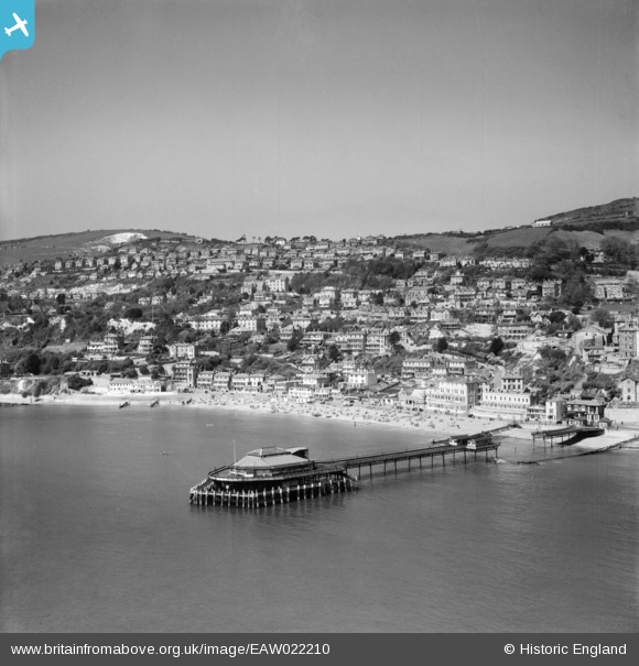
EAW022210 ENGLAND (1949). Royal Victoria Pier and the town, Ventnor, from the south-east, 1949
    © Copyright OpenStreetMap contributors and licensed by the OpenStreetMap Foundation. 2025. Cartography is licensed as CC BY-SA.
  
Nearby Images (21)
Details
| Title | [EAW022210] Royal Victoria Pier and the town, Ventnor, from the south-east, 1949 | 
| Reference | EAW022210 | 
| Date | 17-May-1949 | 
| Link | |
| Place name | VENTNOR | 
| Parish | VENTNOR | 
| District | |
| Country | ENGLAND | 
| Easting / Northing | 456343, 77176 | 
| Longitude / Latitude | -1.2039416459175, 50.591003162604 | 
| National Grid Reference | SZ563772 | 
Pins
|  At the start of WW2 many seaside piers had a section demolished to render them unusable during a possible invasion attempt. |   rivermersey | Monday 11th of May 2020 11:40:06 PM | 
|  The 2nd picture shows Red Funnel's Lorna Doone berthing in the late 1930s with the pier intact. There is no record of when the collapse happened but after the Second World War the pier was not repaired and re-opened until 1953 when the first call was made by the rather inaptly named Cardiff Queen on a day trip from Brighton on 25th May. |   Billy Turner | Tuesday 8th of March 2016 03:55:23 PM | 
 
             
  ![[EAW022210] Royal Victoria Pier and the town, Ventnor, from the south-east, 1949](http://britainfromabove.org.uk/sites/all/libraries/aerofilms-images/public/100x100/EAW/022/EAW022210.jpg) 
  
                                          ![[EPW023096] The Royal Victoria Pier and Ventnor Bay, Ventnor, 1928](http://britainfromabove.org.uk/sites/all/libraries/aerofilms-images/public/100x100/EPW/023/EPW023096.jpg) 
 ![[EAW022208] Royal Victoria Pier and the Esplanade, Ventnor, from the south-east, 1949](http://britainfromabove.org.uk/sites/all/libraries/aerofilms-images/public/100x100/EAW/022/EAW022208.jpg) 
 ![[EPW023097] The Royal Victoria Pier and Ventnor Bay, Ventnor, 1928](http://britainfromabove.org.uk/sites/all/libraries/aerofilms-images/public/100x100/EPW/023/EPW023097.jpg) 
 ![[EAW038594] Mill Cove, Royal Victoria Pier and Ventnor Bay, Ventnor, 1951. This image has been produced from a print.](http://britainfromabove.org.uk/sites/all/libraries/aerofilms-images/public/100x100/EAW/038/EAW038594.jpg) 
 ![[EAW015243] The Royal Victoria Pier, Ventnor Bay and the town, Ventnor, 1948](http://britainfromabove.org.uk/sites/all/libraries/aerofilms-images/public/100x100/EAW/015/EAW015243.jpg) 
 ![[EPW039656] Ventnor Bay and the pier, Ventnor, 1932](http://britainfromabove.org.uk/sites/all/libraries/aerofilms-images/public/100x100/EPW/039/EPW039656.jpg) 
 ![[EAW022209] Royal Victoria Pier, Ventnor Radar Station and the town, Ventnor, from the south, 1949](http://britainfromabove.org.uk/sites/all/libraries/aerofilms-images/public/100x100/EAW/022/EAW022209.jpg) 
 ![[EPW000505] Ventnor, Isle of Wight, from the south-east, 1920](http://britainfromabove.org.uk/sites/all/libraries/aerofilms-images/public/100x100/EPW/000/EPW000505.jpg) 
 ![[EAW022207] Royal Victoria Pier and the town, Ventnor, from the south, 1949](http://britainfromabove.org.uk/sites/all/libraries/aerofilms-images/public/100x100/EAW/022/EAW022207.jpg) 
 ![[EPW023099] Ventnor Bay and the Esplanade, Ventnor, 1928](http://britainfromabove.org.uk/sites/all/libraries/aerofilms-images/public/100x100/EPW/023/EPW023099.jpg) 
 ![[EAW038592] Royal Victoria Pier and Ventnor Bay, Ventnor, 1951. This image has been produced from a print.](http://britainfromabove.org.uk/sites/all/libraries/aerofilms-images/public/100x100/EAW/038/EAW038592.jpg) 
 ![[EPW043010] The Royal Victoria Pier, the Esplanade and the town, Ventnor, 1933](http://britainfromabove.org.uk/sites/all/libraries/aerofilms-images/public/100x100/EPW/043/EPW043010.jpg) 
 ![[EPW032286] Ventnor Bay, the Royal Victoria Pier and the town centre, Ventnor, 1930](http://britainfromabove.org.uk/sites/all/libraries/aerofilms-images/public/100x100/EPW/032/EPW032286.jpg) 
 ![[EPW039654] The coastline from Ventnor Park to Dunnose, Ventnor, from the south-west, 1932](http://britainfromabove.org.uk/sites/all/libraries/aerofilms-images/public/100x100/EPW/039/EPW039654.jpg) 
 ![[EPW022979] Ventnor Bay and Esplanade, Ventnor, 1928](http://britainfromabove.org.uk/sites/all/libraries/aerofilms-images/public/100x100/EPW/022/EPW022979.jpg) 
 ![[EPW032287] The Royal Victoria Pier, the town centre and St Boniface Down, Ventnor, 1930](http://britainfromabove.org.uk/sites/all/libraries/aerofilms-images/public/100x100/EPW/032/EPW032287.jpg) 
 ![[EAW015242] The Royal Victoria Pier, Esplanade and the town, Ventnor, 1948](http://britainfromabove.org.uk/sites/all/libraries/aerofilms-images/public/100x100/EAW/015/EAW015242.jpg) 
 ![[EAW038593] Royal Victoria Pier and the town, Ventnor, 1951. This image has been produced from a print.](http://britainfromabove.org.uk/sites/all/libraries/aerofilms-images/public/100x100/EAW/038/EAW038593.jpg) 
 ![[EPW022977] The sea front, Ventnor, 1928. This image has been produced from a damaged print.](http://britainfromabove.org.uk/sites/all/libraries/aerofilms-images/public/100x100/EPW/022/EPW022977.jpg) 
 ![[EPW039653] The Royal Victoria Pier and the town, Ventnor, 1932](http://britainfromabove.org.uk/sites/all/libraries/aerofilms-images/public/100x100/EPW/039/EPW039653.jpg) 
 