
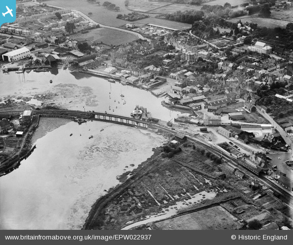
EPW022937 ENGLAND (1928). Lymington Railway Bridge and the harbour, Lymington, 1928
© Copyright OpenStreetMap contributors and licensed by the OpenStreetMap Foundation. 2026. Cartography is licensed as CC BY-SA.
Nearby Images (15)
EPW022937

EPW013642

EPW013646

EPW037448

EAW018160

EPW022938

EPW022939

EPW022930

EAW025812

EAW025816

EAW025810

EAW025811

EPW022933

EAW025813

EAW025819

Details
| Title | [EPW022937] Lymington Railway Bridge and the harbour, Lymington, 1928 |
| Reference | EPW022937 |
| Date | August-1928 |
| Link | |
| Place name | LYMINGTON |
| Parish | LYMINGTON AND PENNINGTON |
| District | |
| Country | ENGLAND |
| Easting / Northing | 432814, 95675 |
| Longitude / Latitude | -1.534720233077, 50.75917094228 |
| National Grid Reference | SZ328957 |
Pins

Class31 |
Saturday 1st of December 2012 08:29:31 AM | |
This is almost certainly PS "Solent", which served the Lymington - Yarmouth route from her building in 1902 at Southampton, until replaced in 1938. Finally scrapped in 1948. |

mannidaze |
Tuesday 8th of January 2013 08:11:44 PM |
|
Class31 |
Saturday 1st of December 2012 08:28:29 AM | |
|
Class31 |
Saturday 1st of December 2012 08:28:01 AM | |
|
Class31 |
Saturday 1st of December 2012 08:25:58 AM |
User Comment Contributions
Lymington and what's that in the platform? |
Roger Traviss |
Friday 29th of June 2012 06:37:11 PM |