
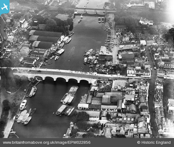
EPW022856 ENGLAND (1928). Kingston Bridge and the riverside, Kingston upon Thames, 1928
© Copyright OpenStreetMap contributors and licensed by the OpenStreetMap Foundation. 2026. Cartography is licensed as CC BY-SA.
Nearby Images (18)
EPW022856

EAW042763

EPW022855

EAW008244

EPW022858

EAW042762

EPW001723

EPW011002

EPR000682

EPW001721

EPW001722

EAW042764

EPW001726

EPW008868

EAW042765

EPW018087

EPW001724

EAW022048

Details
| Title | [EPW022856] Kingston Bridge and the riverside, Kingston upon Thames, 1928 |
| Reference | EPW022856 |
| Date | August-1928 |
| Link | |
| Place name | KINGSTON UPON THAMES |
| Parish | |
| District | |
| Country | ENGLAND |
| Easting / Northing | 517755, 169386 |
| Longitude / Latitude | -0.30664114027362, 51.410759281422 |
| National Grid Reference | TQ178694 |
Pins

UPONTHAMES |
Monday 6th of November 2023 08:53:41 PM | |
|
Pip |
Thursday 2nd of January 2014 01:06:28 AM | |
|
Pip |
Thursday 2nd of January 2014 01:05:52 AM | |
|
Pip |
Thursday 2nd of January 2014 01:05:20 AM | |
|
valo |
Thursday 27th of June 2013 11:35:13 AM |
User Comment Contributions
Kingston upon Thames |

Alan McFaden |
Thursday 4th of December 2014 09:33:31 AM |
Kingston Bridge |
Alan McFaden |
Thursday 4th of December 2014 09:33:06 AM |