
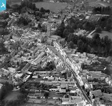
EPW022413 ENGLAND (1928). St John the Baptist's Church and the Corn Hall, Cirencester, 1928

© Copyright OpenStreetMap contributors and licensed by the OpenStreetMap Foundation. 2026. Cartography is licensed as CC BY-SA.
Nearby Images (19)
EPW022413

EAW006877

EPW022417

EAW031681

EPW022410

EPW006310

EPW022416

EPW022415

EPW022412

EPW061780

EPW061775

EPW061776

EPW022407

EAW031677

EAW006878

EAW031680

EPW061778

EPW022409

EPW061779

Details
| Title | [EPW022413] St John the Baptist's Church and the Corn Hall, Cirencester, 1928 |
| Reference | EPW022413 |
| Date | August-1928 |
| Link | |
| Place name | CIRENCESTER |
| Parish | CIRENCESTER |
| District | |
| Country | ENGLAND |
| Easting / Northing | 402361, 202046 |
| Longitude / Latitude | -1.9658204804632, 51.716678852829 |
| National Grid Reference | SP024020 |
Pins

Class31 |
Friday 21st of June 2013 07:09:56 AM | |
|
Class31 |
Monday 10th of June 2013 10:00:50 PM | |
|
Class31 |
Thursday 24th of January 2013 08:36:27 PM | |
|
Class31 |
Thursday 24th of January 2013 08:33:17 PM | |
|
Class31 |
Thursday 24th of January 2013 08:32:45 PM | |
|
Class31 |
Thursday 24th of January 2013 08:32:12 PM | |
|
Class31 |
Thursday 24th of January 2013 08:31:18 PM | |
|
Class31 |
Sunday 28th of October 2012 11:21:57 PM | |
|
Class31 |
Sunday 28th of October 2012 11:21:13 PM | |
|
Class31 |
Sunday 28th of October 2012 11:20:44 PM | |

Tetbury |
Wednesday 27th of June 2012 09:22:54 PM | |
|
Tetbury |
Wednesday 27th of June 2012 08:53:43 PM | |
|
Tetbury |
Wednesday 27th of June 2012 08:08:34 PM |


User Comment Contributions
Cirencester, view from the south east |
Hefin Meara |
Tuesday 22nd of January 2013 12:13:06 PM |