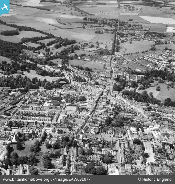
EAW031677 ENGLAND (1950). The town centre, Cirencester, 1950
© Copyright OpenStreetMap contributors and licensed by the OpenStreetMap Foundation. 2026. Cartography is licensed as CC BY-SA.
Nearby Images (19)
Details
| Title | [EAW031677] The town centre, Cirencester, 1950 |
| Reference | EAW031677 |
| Date | 3-August-1950 |
| Link | |
| Place name | CIRENCESTER |
| Parish | CIRENCESTER |
| District | |
| Country | ENGLAND |
| Easting / Northing | 402186, 202054 |
| Longitude / Latitude | -1.968353854604, 51.716751499776 |
| National Grid Reference | SP022021 |
Pins

gBr |
Sunday 30th of August 2015 06:07:39 PM | |

Alan McFaden |
Wednesday 21st of May 2014 09:33:30 PM | |

Alan McFaden |
Wednesday 21st of May 2014 09:32:41 PM |


![[EAW031677] The town centre, Cirencester, 1950](http://britainfromabove.org.uk/sites/all/libraries/aerofilms-images/public/100x100/EAW/031/EAW031677.jpg)
![[EPW022407] The Town Centre and the Fosse Way, Cirencester, from the north-east, 1928](http://britainfromabove.org.uk/sites/all/libraries/aerofilms-images/public/100x100/EPW/022/EPW022407.jpg)
![[EPW022412] St John the Baptist's Church and Cirencester Park, Cirencester, 1928](http://britainfromabove.org.uk/sites/all/libraries/aerofilms-images/public/100x100/EPW/022/EPW022412.jpg)
![[EAW031680] Cirencester Park, St John the Baptist's Church and the town centre, Cirencester, 1950](http://britainfromabove.org.uk/sites/all/libraries/aerofilms-images/public/100x100/EAW/031/EAW031680.jpg)
![[EPW022416] St John the Baptist's Church and Market Place, Cirencester, 1928](http://britainfromabove.org.uk/sites/all/libraries/aerofilms-images/public/100x100/EPW/022/EPW022416.jpg)
![[EPW022410] The Town Centre, Cirencester, from the north-west, 1928](http://britainfromabove.org.uk/sites/all/libraries/aerofilms-images/public/100x100/EPW/022/EPW022410.jpg)
![[EPW006310] The town centre, Cirencester, 1921](http://britainfromabove.org.uk/sites/all/libraries/aerofilms-images/public/100x100/EPW/006/EPW006310.jpg)
![[EAW031681] St John the Baptist's Church and the town centre, Cirencester, 1950](http://britainfromabove.org.uk/sites/all/libraries/aerofilms-images/public/100x100/EAW/031/EAW031681.jpg)
![[EAW015789] Cirencester Park, Cirencester, 1948. This image has been produced from a print.](http://britainfromabove.org.uk/sites/all/libraries/aerofilms-images/public/100x100/EAW/015/EAW015789.jpg)
![[EAW015788] The 188th US Army General Hospital in Cirencester Park, Cirencester, from the east, 1948. This image has been produced from a print marked by Aerofilms Ltd for photo editing.](http://britainfromabove.org.uk/sites/all/libraries/aerofilms-images/public/100x100/EAW/015/EAW015788.jpg)
![[EAW006877] The town centre, Cirencester, 1947](http://britainfromabove.org.uk/sites/all/libraries/aerofilms-images/public/100x100/EAW/006/EAW006877.jpg)
![[EPW022413] St John the Baptist's Church and the Corn Hall, Cirencester, 1928](http://britainfromabove.org.uk/sites/all/libraries/aerofilms-images/public/100x100/EPW/022/EPW022413.jpg)
![[EPW061776] St John the Baptist's Church and Abbey House, Cirencester, 1939](http://britainfromabove.org.uk/sites/all/libraries/aerofilms-images/public/100x100/EPW/061/EPW061776.jpg)
![[EPW061775] Abbey House, Cirencester, 1939](http://britainfromabove.org.uk/sites/all/libraries/aerofilms-images/public/100x100/EPW/061/EPW061775.jpg)
![[EPW061780] St John the Baptist's Church and Abbey House, Cirencester, 1939](http://britainfromabove.org.uk/sites/all/libraries/aerofilms-images/public/100x100/EPW/061/EPW061780.jpg)
![[EAW015790] Cirencester Park, Cirencester, from the west, 1948. This image has been produced from a print.](http://britainfromabove.org.uk/sites/all/libraries/aerofilms-images/public/100x100/EAW/015/EAW015790.jpg)
![[EAW031679] Cirencester Park and the Broad Ride, Cirencester, 1950](http://britainfromabove.org.uk/sites/all/libraries/aerofilms-images/public/100x100/EAW/031/EAW031679.jpg)
![[EPW022417] The Town Centre, Cirencester, 1928](http://britainfromabove.org.uk/sites/all/libraries/aerofilms-images/public/100x100/EPW/022/EPW022417.jpg)
![[EAW006878] The town, Cirencester, 1947](http://britainfromabove.org.uk/sites/all/libraries/aerofilms-images/public/100x100/EAW/006/EAW006878.jpg)

