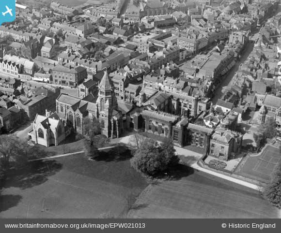
EPW021013 ENGLAND (1928). Rugby School and Memorial Chapel, Rugby, 1928
© Copyright OpenStreetMap contributors and licensed by the OpenStreetMap Foundation. 2026. Cartography is licensed as CC BY-SA.
Nearby Images (7)
Details
| Title | [EPW021013] Rugby School and Memorial Chapel, Rugby, 1928 |
| Reference | EPW021013 |
| Date | April-1928 |
| Link | |
| Place name | RUGBY |
| Parish | |
| District | |
| Country | ENGLAND |
| Easting / Northing | 450243, 274962 |
| Longitude / Latitude | -1.2619579603054, 52.370016319162 |
| National Grid Reference | SP502750 |
Pins
Be the first to add a comment to this image!


![[EPW021013] Rugby School and Memorial Chapel, Rugby, 1928](http://britainfromabove.org.uk/sites/all/libraries/aerofilms-images/public/100x100/EPW/021/EPW021013.jpg)
![[EPW005577] The Town Centre, Rugby, from the south-west, 1921](http://britainfromabove.org.uk/sites/all/libraries/aerofilms-images/public/100x100/EPW/005/EPW005577.jpg)
![[EAW006309] Rugby School and the town, Rugby, from the south, 1947](http://britainfromabove.org.uk/sites/all/libraries/aerofilms-images/public/100x100/EAW/006/EAW006309.jpg)
![[EPW001339] Rugby School and the town centre, Rugby, 1920](http://britainfromabove.org.uk/sites/all/libraries/aerofilms-images/public/100x100/EPW/001/EPW001339.jpg)
![[EPW010524] Rugby School and view over the town, Rugby, 1924](http://britainfromabove.org.uk/sites/all/libraries/aerofilms-images/public/100x100/EPW/010/EPW010524.jpg)
![[EAW006310] Rugby School and the town, Rugby, from the south-east, 1947](http://britainfromabove.org.uk/sites/all/libraries/aerofilms-images/public/100x100/EAW/006/EAW006310.jpg)
![[EPW021015] Chapel Street and St Andrew's Church, Rugby, 1928](http://britainfromabove.org.uk/sites/all/libraries/aerofilms-images/public/100x100/EPW/021/EPW021015.jpg)