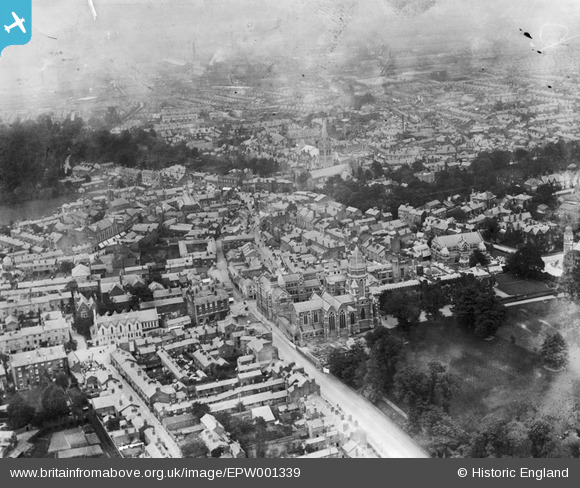
EPW001339 ENGLAND (1920). Rugby School and the town centre, Rugby, 1920
© Copyright OpenStreetMap contributors and licensed by the OpenStreetMap Foundation. 2026. Cartography is licensed as CC BY-SA.
Nearby Images (8)
Details
| Title | [EPW001339] Rugby School and the town centre, Rugby, 1920 |
| Reference | EPW001339 |
| Date | May-1920 |
| Link | |
| Place name | RUGBY |
| Parish | |
| District | |
| Country | ENGLAND |
| Easting / Northing | 450278, 275088 |
| Longitude / Latitude | -1.2614249809753, 52.371145901554 |
| National Grid Reference | SP503751 |
Pins

Class31 |
Tuesday 5th of May 2015 07:48:28 PM | |

Class31 |
Tuesday 5th of May 2015 07:47:29 PM | |

Eliz |
Friday 6th of June 2014 10:51:49 PM | |

Ian Robinson |
Sunday 7th of October 2012 09:29:03 PM |
User Comment Contributions
Theatre, Rugby School, 04/05/2015 |

Class31 |
Tuesday 5th of May 2015 07:49:21 PM |


![[EPW001339] Rugby School and the town centre, Rugby, 1920](http://britainfromabove.org.uk/sites/all/libraries/aerofilms-images/public/100x100/EPW/001/EPW001339.jpg)
![[EPW021015] Chapel Street and St Andrew's Church, Rugby, 1928](http://britainfromabove.org.uk/sites/all/libraries/aerofilms-images/public/100x100/EPW/021/EPW021015.jpg)
![[EPW021013] Rugby School and Memorial Chapel, Rugby, 1928](http://britainfromabove.org.uk/sites/all/libraries/aerofilms-images/public/100x100/EPW/021/EPW021013.jpg)
![[EPW005577] The Town Centre, Rugby, from the south-west, 1921](http://britainfromabove.org.uk/sites/all/libraries/aerofilms-images/public/100x100/EPW/005/EPW005577.jpg)
![[EPW010531] Chapel Street and environs, Rugby, 1924](http://britainfromabove.org.uk/sites/all/libraries/aerofilms-images/public/100x100/EPW/010/EPW010531.jpg)
![[EAW006309] Rugby School and the town, Rugby, from the south, 1947](http://britainfromabove.org.uk/sites/all/libraries/aerofilms-images/public/100x100/EAW/006/EAW006309.jpg)
![[EAW006310] Rugby School and the town, Rugby, from the south-east, 1947](http://britainfromabove.org.uk/sites/all/libraries/aerofilms-images/public/100x100/EAW/006/EAW006310.jpg)
![[EPW021018] St Andrew's Church and environs, Rugby, 1928](http://britainfromabove.org.uk/sites/all/libraries/aerofilms-images/public/100x100/EPW/021/EPW021018.jpg)