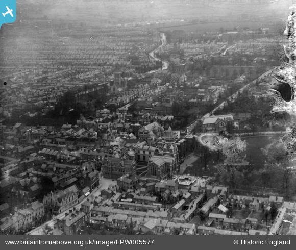
EPW005577 ENGLAND (1921). The Town Centre, Rugby, from the south-west, 1921
© Copyright OpenStreetMap contributors and licensed by the OpenStreetMap Foundation. 2026. Cartography is licensed as CC BY-SA.
Nearby Images (7)
Details
| Title | [EPW005577] The Town Centre, Rugby, from the south-west, 1921 |
| Reference | EPW005577 |
| Date | March-1921 |
| Link | |
| Place name | RUGBY |
| Parish | |
| District | |
| Country | ENGLAND |
| Easting / Northing | 450198, 274966 |
| Longitude / Latitude | -1.2626183272474, 52.370056406508 |
| National Grid Reference | SP502750 |
Pins

Class31 |
Tuesday 5th of May 2015 07:53:36 PM | |

NCTaylor |
Wednesday 6th of August 2014 06:56:40 PM | |

Ian Robinson |
Sunday 23rd of September 2012 08:51:07 PM | |

Ian Robinson |
Sunday 23rd of September 2012 08:49:28 PM | |

Ian Robinson |
Sunday 23rd of September 2012 08:48:33 PM | |

Ian Robinson |
Sunday 23rd of September 2012 08:47:56 PM | |

Ian Robinson |
Sunday 23rd of September 2012 08:46:15 PM | |

Ian Robinson |
Sunday 23rd of September 2012 08:45:14 PM | |

Ian Robinson |
Sunday 23rd of September 2012 08:44:44 PM | |

Ian Robinson |
Sunday 23rd of September 2012 08:43:50 PM | |

Ian Robinson |
Sunday 23rd of September 2012 08:42:27 PM |
User Comment Contributions
Temple Speech Room, Rugby School, Rugby, 04/05/2015 |

Class31 |
Tuesday 5th of May 2015 07:52:53 PM |


![[EPW005577] The Town Centre, Rugby, from the south-west, 1921](http://britainfromabove.org.uk/sites/all/libraries/aerofilms-images/public/100x100/EPW/005/EPW005577.jpg)
![[EPW021013] Rugby School and Memorial Chapel, Rugby, 1928](http://britainfromabove.org.uk/sites/all/libraries/aerofilms-images/public/100x100/EPW/021/EPW021013.jpg)
![[EAW006309] Rugby School and the town, Rugby, from the south, 1947](http://britainfromabove.org.uk/sites/all/libraries/aerofilms-images/public/100x100/EAW/006/EAW006309.jpg)
![[EPW001339] Rugby School and the town centre, Rugby, 1920](http://britainfromabove.org.uk/sites/all/libraries/aerofilms-images/public/100x100/EPW/001/EPW001339.jpg)
![[EPW010524] Rugby School and view over the town, Rugby, 1924](http://britainfromabove.org.uk/sites/all/libraries/aerofilms-images/public/100x100/EPW/010/EPW010524.jpg)
![[EPW021015] Chapel Street and St Andrew's Church, Rugby, 1928](http://britainfromabove.org.uk/sites/all/libraries/aerofilms-images/public/100x100/EPW/021/EPW021015.jpg)
![[EAW006310] Rugby School and the town, Rugby, from the south-east, 1947](http://britainfromabove.org.uk/sites/all/libraries/aerofilms-images/public/100x100/EAW/006/EAW006310.jpg)