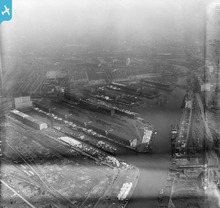
EPW019157 ENGLAND (1927). Salford Docks, Salford, 1927
© Copyright OpenStreetMap contributors and licensed by the OpenStreetMap Foundation. 2026. Cartography is licensed as CC BY-SA.
Nearby Images (14)
Details
| Title | [EPW019157] Salford Docks, Salford, 1927 |
| Reference | EPW019157 |
| Date | August-1927 |
| Link | |
| Place name | SALFORD |
| Parish | |
| District | |
| Country | ENGLAND |
| Easting / Northing | 380827, 397120 |
| Longitude / Latitude | -2.2888695768801, 53.470213121669 |
| National Grid Reference | SJ808971 |
Pins
Be the first to add a comment to this image!
User Comment Contributions

Frank S |
Saturday 30th of June 2012 11:06:54 AM |


![[EPW019157] Salford Docks, Salford, 1927](http://britainfromabove.org.uk/sites/all/libraries/aerofilms-images/public/100x100/EPW/019/EPW019157.jpg)
![[EAW006235] The Salford Docks and Manchester Ship Canal, Salford, 1947](http://britainfromabove.org.uk/sites/all/libraries/aerofilms-images/public/100x100/EAW/006/EAW006235.jpg)
![[EAW050416] Manchester Docks, Salford, from the south, 1953](http://britainfromabove.org.uk/sites/all/libraries/aerofilms-images/public/100x100/EAW/050/EAW050416.jpg)
![[EPW028014] Salford Docks, Salford, 1929](http://britainfromabove.org.uk/sites/all/libraries/aerofilms-images/public/100x100/EPW/028/EPW028014.jpg)
![[EAW021935] Manchester Docks, Salford, 1949. This image has been produced from a print.](http://britainfromabove.org.uk/sites/all/libraries/aerofilms-images/public/100x100/EAW/021/EAW021935.jpg)
![[EAW006236] The Salford Docks and Manchester Ship Canal, Salford, 1947](http://britainfromabove.org.uk/sites/all/libraries/aerofilms-images/public/100x100/EAW/006/EAW006236.jpg)
![[EPW027860] The Salford Docks and the Manchester Ship Canal, Salford, 1929](http://britainfromabove.org.uk/sites/all/libraries/aerofilms-images/public/100x100/EPW/027/EPW027860.jpg)
![[EPW027781] Railway sidings and warehouses at the Salford Docks, Salford, 1929](http://britainfromabove.org.uk/sites/all/libraries/aerofilms-images/public/100x100/EPW/027/EPW027781.jpg)
![[EPW041685] The Salford Quays, Salford, 1933](http://britainfromabove.org.uk/sites/all/libraries/aerofilms-images/public/100x100/EPW/041/EPW041685.jpg)
![[EAW000804] Salford Docks, Salford, 1946](http://britainfromabove.org.uk/sites/all/libraries/aerofilms-images/public/100x100/EAW/000/EAW000804.jpg)
![[EPW027857] The Salford Docks, Salford, 1929](http://britainfromabove.org.uk/sites/all/libraries/aerofilms-images/public/100x100/EPW/027/EPW027857.jpg)
![[EPW028015] No. 9 Dock at Salford Quays, Salford, 1929](http://britainfromabove.org.uk/sites/all/libraries/aerofilms-images/public/100x100/EPW/028/EPW028015.jpg)
![[EPW017596] No. 9 Dock, Salford Quays, 1927](http://britainfromabove.org.uk/sites/all/libraries/aerofilms-images/public/100x100/EPW/017/EPW017596.jpg)
![[EAW050417] Manchester Docks, Salford, from the south-east, 1953](http://britainfromabove.org.uk/sites/all/libraries/aerofilms-images/public/100x100/EAW/050/EAW050417.jpg)
