
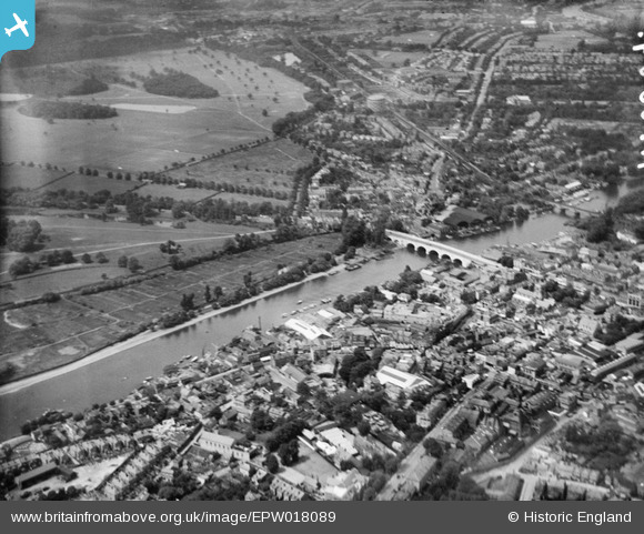
EPW018089 ENGLAND (1927). Kingston Bridge and the River Thames, Kingston upon Thames, from the south-east, 1927
© Copyright OpenStreetMap contributors and licensed by the OpenStreetMap Foundation. 2026. Cartography is licensed as CC BY-SA.
Nearby Images (11)
EPW018089

EPW010999

EPW011000

EPR000681

EPR000680

EPW008869

EPW008868

EAW042765

EAW042764

EPW011002

EPW005057

Details
| Title | [EPW018089] Kingston Bridge and the River Thames, Kingston upon Thames, from the south-east, 1927 |
| Reference | EPW018089 |
| Date | May-1927 |
| Link | |
| Place name | KINGSTON UPON THAMES |
| Parish | |
| District | |
| Country | ENGLAND |
| Easting / Northing | 517840, 169056 |
| Longitude / Latitude | -0.30552906092042, 51.407775345469 |
| National Grid Reference | TQ178691 |
Pins

yes |
Monday 14th of July 2025 07:15:17 AM | |
|
Leslie B |
Sunday 27th of March 2016 06:44:27 PM | |
|
Pip |
Thursday 2nd of January 2014 12:33:31 AM | |
|
Johnners |
Monday 16th of July 2012 11:18:37 AM | |
|
Arty |
Friday 13th of July 2012 04:55:19 PM | |
|
Arty |
Friday 13th of July 2012 04:54:17 PM | |

Jon |
Friday 29th of June 2012 09:16:20 PM | |
|
Jon |
Friday 29th of June 2012 09:15:55 PM |
User Comment Contributions

Kingston Bridge 2011 |

Alan McFaden |
Friday 7th of November 2014 05:28:58 PM |
Definitely Kingston-upon-Thames |
Hilton |
Sunday 29th of July 2012 10:43:28 PM |
Dear all, That’s great; we’ve reviewed your comments and thanks to your help we can update the catalogue. The revised record will appear here in due course, as for EPW018087-8. Thank you! Katy Whitaker Britain from Above Cataloguer |
Katy Whitaker |
Monday 2nd of July 2012 03:59:04 PM |
This one has the same bridges, with boat sheds between them, as http://www.britainfromabove.org.uk/image/epw018087 and so this must be Kingston upon Thames too. |
Nigel Davies |
Tuesday 26th of June 2012 01:39:40 PM |
Kingston Bridge and the River Thames. Bushy Park to the left, Hampton Wick on left of River. Railway bridge is the second bridge beyond the boathouses. |
Prentman |
Tuesday 26th of June 2012 10:28:45 AM |