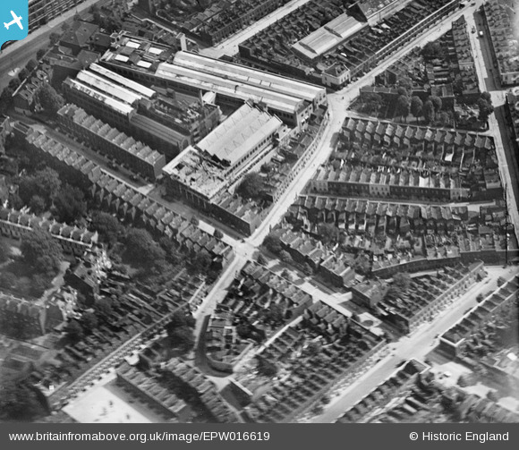
EPW016619 ENGLAND (1926). The Waygood Otis Engineering Works, Bermondsey, 1926
© Copyright OpenStreetMap contributors and licensed by the OpenStreetMap Foundation. 2026. Cartography is licensed as CC BY-SA.
Nearby Images (28)
Details
| Title | [EPW016619] The Waygood Otis Engineering Works, Bermondsey, 1926 |
| Reference | EPW016619 |
| Date | August-1926 |
| Link | |
| Place name | BERMONDSEY |
| Parish | |
| District | |
| Country | ENGLAND |
| Easting / Northing | 532535, 179280 |
| Longitude / Latitude | -0.090511409362742, 51.496420148669 |
| National Grid Reference | TQ325793 |


![[EPW016619] The Waygood Otis Engineering Works, Bermondsey, 1926](http://britainfromabove.org.uk/sites/all/libraries/aerofilms-images/public/100x100/EPW/016/EPW016619.jpg)
![[EPW015760] Falmouth Road and environs, Bermondsey, 1926. This image has been produced from a print.](http://britainfromabove.org.uk/sites/all/libraries/aerofilms-images/public/100x100/EPW/015/EPW015760.jpg)
![[EPW015752] Great Dover Street and environs, Bermondsey, 1926](http://britainfromabove.org.uk/sites/all/libraries/aerofilms-images/public/100x100/EPW/015/EPW015752.jpg)
![[EAW021506] Falmouth Road and environs, Newington, 1949. This image has been produced from a damaged negative.](http://britainfromabove.org.uk/sites/all/libraries/aerofilms-images/public/100x100/EAW/021/EAW021506.jpg)
![[EAW021510] Falmouth Road, the Rockingham Estate and environs, Newington, 1949. This image has been produced from a print marked by Aerofilms Ltd for photo editing.](http://britainfromabove.org.uk/sites/all/libraries/aerofilms-images/public/100x100/EAW/021/EAW021510.jpg)
![[EPW015759] Falmouth Road and environs, Bermondsey, 1926. This image has been produced from a print.](http://britainfromabove.org.uk/sites/all/libraries/aerofilms-images/public/100x100/EPW/015/EPW015759.jpg)
![[EAW021509] Great Dover Street, Deverell Street and environs, Newington, 1949. This image has been produced from a print marked by Aerofilms Ltd for photo editing.](http://britainfromabove.org.uk/sites/all/libraries/aerofilms-images/public/100x100/EAW/021/EAW021509.jpg)
![[EPW016620] The Waygood Otis Engineering Works and environs, Bermondsey, 1926](http://britainfromabove.org.uk/sites/all/libraries/aerofilms-images/public/100x100/EPW/016/EPW016620.jpg)
![[EPW015751] Harper Road, Great Dover Street and environs, Bermondsey, 1926. This image has been produced from a print marked by Aerofilms Ltd for photo editing.](http://britainfromabove.org.uk/sites/all/libraries/aerofilms-images/public/100x100/EPW/015/EPW015751.jpg)
![[EPW007728] The Waygood Otis Engineering Works, Newington, 1922](http://britainfromabove.org.uk/sites/all/libraries/aerofilms-images/public/100x100/EPW/007/EPW007728.jpg)
![[EAW021505] Falmouth Road and environs, Newington, 1949. This image has been produced from a damaged negative.](http://britainfromabove.org.uk/sites/all/libraries/aerofilms-images/public/100x100/EAW/021/EAW021505.jpg)
![[EPW007725] The Waygood Otis Engineering Works, Newington, 1922](http://britainfromabove.org.uk/sites/all/libraries/aerofilms-images/public/100x100/EPW/007/EPW007725.jpg)
![[EPW015749] Great Dover Street and environs, Bermondsey, 1926](http://britainfromabove.org.uk/sites/all/libraries/aerofilms-images/public/100x100/EPW/015/EPW015749.jpg)
![[EPW007726] The Waygood Otis Engineering Works and Merrick Square, Newington, 1922](http://britainfromabove.org.uk/sites/all/libraries/aerofilms-images/public/100x100/EPW/007/EPW007726.jpg)
![[EAW021500] Falmouth Road and environs, Newington, 1949. This image was marked by Aerofilms Ltd for photo editing.](http://britainfromabove.org.uk/sites/all/libraries/aerofilms-images/public/100x100/EAW/021/EAW021500.jpg)
![[EAW021507] Great Dover Street and environs, Newington, 1949. This image has been produced from a print marked by Aerofilms Ltd for photo editing.](http://britainfromabove.org.uk/sites/all/libraries/aerofilms-images/public/100x100/EAW/021/EAW021507.jpg)
![[EPW007724] The Waygood Otis Engineering Works, Newington, 1922](http://britainfromabove.org.uk/sites/all/libraries/aerofilms-images/public/100x100/EPW/007/EPW007724.jpg)
![[EPW015750] Great Dover Street and environs, Bermondsey, 1926](http://britainfromabove.org.uk/sites/all/libraries/aerofilms-images/public/100x100/EPW/015/EPW015750.jpg)
![[EAW021502] Great Dover Street and environs, Newington, 1949. This image has been produced from a damaged negative.](http://britainfromabove.org.uk/sites/all/libraries/aerofilms-images/public/100x100/EAW/021/EAW021502.jpg)
![[EPW007727] The Waygood Otis Engineering Works, Newington, 1922](http://britainfromabove.org.uk/sites/all/libraries/aerofilms-images/public/100x100/EPW/007/EPW007727.jpg)
![[EPW015753] Falmouth Road and environs, Bermondsey, 1926. This image has been produced from a print affected by flare.](http://britainfromabove.org.uk/sites/all/libraries/aerofilms-images/public/100x100/EPW/015/EPW015753.jpg)
![[EAW021501] Deverell Street and environs, Newington, 1949. This image has been produced from a damaged negative.](http://britainfromabove.org.uk/sites/all/libraries/aerofilms-images/public/100x100/EAW/021/EAW021501.jpg)
![[EAW021508] Falmouth Road, the Rockingham Estate and environs, Newington, 1949. This image has been produced from a print marked by Aerofilms Ltd for photo editing.](http://britainfromabove.org.uk/sites/all/libraries/aerofilms-images/public/100x100/EAW/021/EAW021508.jpg)
![[EPW007723] The Waygood Otis Engineering Works, Newington, 1922](http://britainfromabove.org.uk/sites/all/libraries/aerofilms-images/public/100x100/EPW/007/EPW007723.jpg)
![[EAW021503] Great Dover Street and environs, Newington, 1949. This image has been produced from a damaged negative.](http://britainfromabove.org.uk/sites/all/libraries/aerofilms-images/public/100x100/EAW/021/EAW021503.jpg)
![[EPW015754] Great Dover Street and environs, Bermondsey, 1926. This image has been produced from a print affected by flare.](http://britainfromabove.org.uk/sites/all/libraries/aerofilms-images/public/100x100/EPW/015/EPW015754.jpg)
![[EAW021504] Great Dover Street and environs, Newington, 1949. This image has been produced from a damaged negative.](http://britainfromabove.org.uk/sites/all/libraries/aerofilms-images/public/100x100/EAW/021/EAW021504.jpg)
![[EPW055342] The Holy Trinity Church, Merrick Square and the surrounding residential area, The Borough, 1937](http://britainfromabove.org.uk/sites/all/libraries/aerofilms-images/public/100x100/EPW/055/EPW055342.jpg)
