
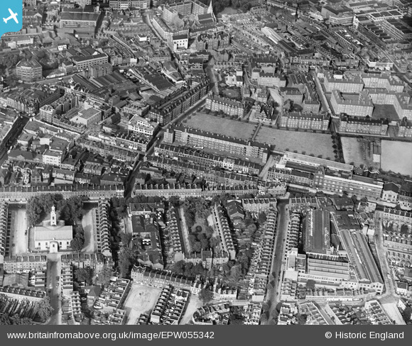
EPW055342 ENGLAND (1937). The Holy Trinity Church, Merrick Square and the surrounding residential area, The Borough, 1937
© Copyright OpenStreetMap contributors and licensed by the OpenStreetMap Foundation. 2026. Cartography is licensed as CC BY-SA.
Nearby Images (24)
EPW055342

EAW021504

EAW021503

EPW007726

EAW021505

EPW015751

EPW007724

EPW015753

EAW021507

EAW021506

EPW015749

EPW007723

EPW007725

EPW007727

EPW007728

EAW021509

EAW000535

EPW015752

EPW015760

EAW021501

EPW016619

EAW021502

EAW021500

EPW015759

Details
| Title | [EPW055342] The Holy Trinity Church, Merrick Square and the surrounding residential area, The Borough, 1937 |
| Reference | EPW055342 |
| Date | 8-September-1937 |
| Link | |
| Place name | THE BOROUGH |
| Parish | |
| District | |
| Country | ENGLAND |
| Easting / Northing | 532602, 179495 |
| Longitude / Latitude | -0.089465874509239, 51.498336748182 |
| National Grid Reference | TQ326795 |
Pins

K Mapes |
Wednesday 23rd of October 2013 06:52:20 AM | |
|
K Mapes |
Wednesday 23rd of October 2013 06:51:08 AM | |
|
Chelsea61 |
Friday 21st of June 2013 06:07:51 PM | |
|
Chelsea61 |
Friday 21st of June 2013 06:06:09 PM | |
|
Chelsea61 |
Friday 21st of June 2013 06:04:54 PM |
User Comment Contributions
Henry Wood Concert Hall |

Alan McFaden |
Saturday 27th of December 2014 05:19:04 PM |