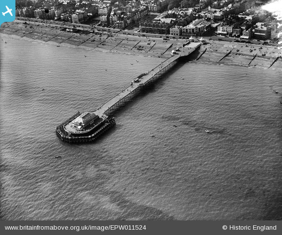
EPW011524 ENGLAND (1924). The Pier, Worthing, 1924
© Copyright OpenStreetMap contributors and licensed by the OpenStreetMap Foundation. 2026. Cartography is licensed as CC BY-SA.
Nearby Images (27)
Details
| Title | [EPW011524] The Pier, Worthing, 1924 |
| Reference | EPW011524 |
| Date | July-1924 |
| Link | |
| Place name | WORTHING |
| Parish | |
| District | |
| Country | ENGLAND |
| Easting / Northing | 515051, 102179 |
| Longitude / Latitude | -0.3669450389065, 50.807163600152 |
| National Grid Reference | TQ151022 |
Pins

Alan McFaden |
Saturday 16th of November 2013 05:35:10 PM | |

Alan McFaden |
Saturday 16th of November 2013 05:34:38 PM | |

Alan McFaden |
Saturday 16th of November 2013 05:33:33 PM |


![[EPW011524] The Pier, Worthing, 1924](http://britainfromabove.org.uk/sites/all/libraries/aerofilms-images/public/100x100/EPW/011/EPW011524.jpg)
![[EPW018751] The pier, bandstand and town, Worthing, from the south-east, 1927](http://britainfromabove.org.uk/sites/all/libraries/aerofilms-images/public/100x100/EPW/018/EPW018751.jpg)
![[EAW022242] The Pier and the town, Worthing, from the south-east, 1949](http://britainfromabove.org.uk/sites/all/libraries/aerofilms-images/public/100x100/EAW/022/EAW022242.jpg)
![[EAW022745] The pier and town, Worthing, from the south-east, 1949](http://britainfromabove.org.uk/sites/all/libraries/aerofilms-images/public/100x100/EAW/022/EAW022745.jpg)
![[EPW000753] The Pier, Worthing, 1920](http://britainfromabove.org.uk/sites/all/libraries/aerofilms-images/public/100x100/EPW/000/EPW000753.jpg)
![[EPW011535] The Pier, Worthing, 1924](http://britainfromabove.org.uk/sites/all/libraries/aerofilms-images/public/100x100/EPW/011/EPW011535.jpg)
![[EAW022244] The Pier and the town, Worthing, from the south, 1949](http://britainfromabove.org.uk/sites/all/libraries/aerofilms-images/public/100x100/EAW/022/EAW022244.jpg)
![[EPW042995] Pavilion at the end of Worthing Pier, Worthing, 1933](http://britainfromabove.org.uk/sites/all/libraries/aerofilms-images/public/100x100/EPW/042/EPW042995.jpg)
![[EAW053163] The pier and the town, Worthing, from the south-east, 1954](http://britainfromabove.org.uk/sites/all/libraries/aerofilms-images/public/100x100/EAW/053/EAW053163.jpg)
![[EPW042998] Worthing Pier and the town, Worthing, from the south, 1933](http://britainfromabove.org.uk/sites/all/libraries/aerofilms-images/public/100x100/EPW/042/EPW042998.jpg)
![[EPW017738] The pier and seafront, Worthing, from the south-east, 1927](http://britainfromabove.org.uk/sites/all/libraries/aerofilms-images/public/100x100/EPW/017/EPW017738.jpg)
![[EPW039495] The Pier and the town, Worthing, from the south-east, 1932](http://britainfromabove.org.uk/sites/all/libraries/aerofilms-images/public/100x100/EPW/039/EPW039495.jpg)
![[EAW022243] The Pier and the seafront, Worthing, from the north-east, 1949](http://britainfromabove.org.uk/sites/all/libraries/aerofilms-images/public/100x100/EAW/022/EAW022243.jpg)
![[EPW039494] Marine Parade, the town and the seafront, Worthing, from the south-west, 1932](http://britainfromabove.org.uk/sites/all/libraries/aerofilms-images/public/100x100/EPW/039/EPW039494.jpg)
![[EAW022746] The pier and seafront, Worthing, from the east, 1949](http://britainfromabove.org.uk/sites/all/libraries/aerofilms-images/public/100x100/EAW/022/EAW022746.jpg)
![[EPW017740] The pier and seafront, Worthing, from the south-east, 1927](http://britainfromabove.org.uk/sites/all/libraries/aerofilms-images/public/100x100/EPW/017/EPW017740.jpg)
![[EPW018750] The pier, bandstand and town, Worthing, from the south-east, 1927](http://britainfromabove.org.uk/sites/all/libraries/aerofilms-images/public/100x100/EPW/018/EPW018750.jpg)
![[EPW017739] The pier pavilion and seafront, Worthing, 1927](http://britainfromabove.org.uk/sites/all/libraries/aerofilms-images/public/100x100/EPW/017/EPW017739.jpg)
![[EPW017741] The pier pavilion and seafront, Worthing, 1927](http://britainfromabove.org.uk/sites/all/libraries/aerofilms-images/public/100x100/EPW/017/EPW017741.jpg)
![[EPW000749] The Pier, Worthing, from the south-west, 1920](http://britainfromabove.org.uk/sites/all/libraries/aerofilms-images/public/100x100/EPW/000/EPW000749.jpg)
![[EPW018752] The pier, bandstand and town, Worthing, 1927](http://britainfromabove.org.uk/sites/all/libraries/aerofilms-images/public/100x100/EPW/018/EPW018752.jpg)
![[EPW054071] The Pier Pavilion and the town, Worthing, from the south-east, 1937](http://britainfromabove.org.uk/sites/all/libraries/aerofilms-images/public/100x100/EPW/054/EPW054071.jpg)
![[EAW022245] The Bandstand (The Lido) and the town, Worthing, from the south, 1949](http://britainfromabove.org.uk/sites/all/libraries/aerofilms-images/public/100x100/EAW/022/EAW022245.jpg)
![[EAW022748] The bandstand and seafront looking towards East Worthing, Worthing, from the south-west, 1949](http://britainfromabove.org.uk/sites/all/libraries/aerofilms-images/public/100x100/EAW/022/EAW022748.jpg)
![[EPW000725] The Pier, Worthing, 1920](http://britainfromabove.org.uk/sites/all/libraries/aerofilms-images/public/100x100/EPW/000/EPW000725.jpg)
![[EPW011532] Marine Parade, Worthing, 1924](http://britainfromabove.org.uk/sites/all/libraries/aerofilms-images/public/100x100/EPW/011/EPW011532.jpg)
![[EAW053164] The Bandstand and the town, Worthing, from the south-east, 1954](http://britainfromabove.org.uk/sites/all/libraries/aerofilms-images/public/100x100/EAW/053/EAW053164.jpg)


