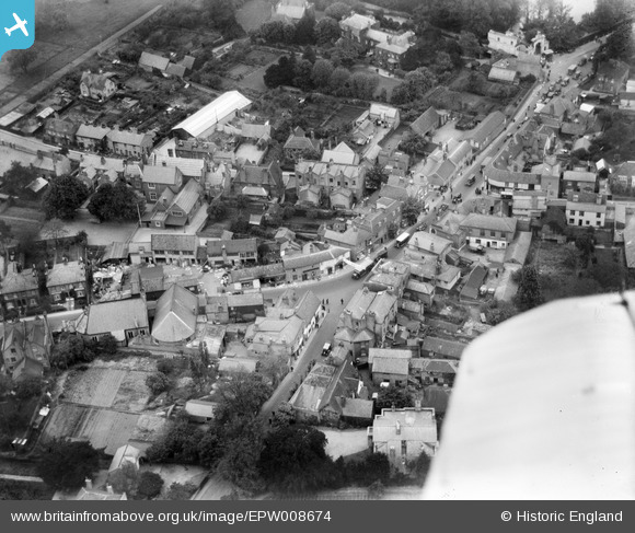
EPW008674 ENGLAND (1923). The High Street, Ewell, 1923
© Copyright OpenStreetMap contributors and licensed by the OpenStreetMap Foundation. 2026. Cartography is licensed as CC BY-SA.
Nearby Images (11)
Details
| Title | [EPW008674] The High Street, Ewell, 1923 |
| Reference | EPW008674 |
| Date | 1923 |
| Link | |
| Place name | EWELL |
| Parish | |
| District | |
| Country | ENGLAND |
| Easting / Northing | 522014, 162566 |
| Longitude / Latitude | -0.24776838925204, 51.348557248313 |
| National Grid Reference | TQ220626 |
Pins

Maurice |
Sunday 29th of June 2014 07:22:55 AM |


![[EPW008674] The High Street, Ewell, 1923](http://britainfromabove.org.uk/sites/all/libraries/aerofilms-images/public/100x100/EPW/008/EPW008674.jpg)
![[EPW008696] The High Street and town centre, Ewell, 1923. This image has been produced from a copy-negative.](http://britainfromabove.org.uk/sites/all/libraries/aerofilms-images/public/100x100/EPW/008/EPW008696.jpg)
![[EPW028293] The High Street, Ewell, 1929](http://britainfromabove.org.uk/sites/all/libraries/aerofilms-images/public/100x100/EPW/028/EPW028293.jpg)
![[EPW008688] The High Street, Ewell, 1923](http://britainfromabove.org.uk/sites/all/libraries/aerofilms-images/public/100x100/EPW/008/EPW008688.jpg)
![[EPW008684] The High Street, Ewell, 1923](http://britainfromabove.org.uk/sites/all/libraries/aerofilms-images/public/100x100/EPW/008/EPW008684.jpg)
![[EPW028295] The village centre, Ewell, 1929](http://britainfromabove.org.uk/sites/all/libraries/aerofilms-images/public/100x100/EPW/028/EPW028295.jpg)
![[EPW028294] Ewell Grove and the village, Ewell, 1929](http://britainfromabove.org.uk/sites/all/libraries/aerofilms-images/public/100x100/EPW/028/EPW028294.jpg)
![[EPW007915] The High Street and environs, Ewell, 1922](http://britainfromabove.org.uk/sites/all/libraries/aerofilms-images/public/100x100/EPW/007/EPW007915.jpg)
![[EPW006246] Ewell Castle and the Old Tower, Ewell, 1921](http://britainfromabove.org.uk/sites/all/libraries/aerofilms-images/public/100x100/EPW/006/EPW006246.jpg)
![[EPW006434] Derby Day traffic near the Spring Hotel, Ewell, 1921. This image has been produced from a copy-negative.](http://britainfromabove.org.uk/sites/all/libraries/aerofilms-images/public/100x100/EPW/006/EPW006434.jpg)
![[EPW006404] Derby Day traffic near the Spring Hotel, Ewell, 1921. This image has been produced from a copy-negative.](http://britainfromabove.org.uk/sites/all/libraries/aerofilms-images/public/100x100/EPW/006/EPW006404.jpg)