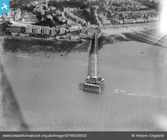
EPW008632 ENGLAND (1923). The Pier, Clevedon, 1923
© Copyright OpenStreetMap contributors and licensed by the OpenStreetMap Foundation. 2025. Cartography is licensed as CC BY-SA.
Nearby Images (9)
Details
| Title | [EPW008632] The Pier, Clevedon, 1923 |
| Reference | EPW008632 |
| Date | 1923 |
| Link | |
| Place name | CLEVEDON |
| Parish | CLEVEDON |
| District | |
| Country | ENGLAND |
| Easting / Northing | 340107, 171970 |
| Longitude / Latitude | -2.8618696396509, 51.443061088176 |
| National Grid Reference | ST401720 |
Pins

James Chandler |
Friday 11th of December 2015 08:23:54 AM |
User Comment Contributions
The end of the pier. |

Class31 |
Monday 24th of June 2013 11:36:50 AM |


![[EPW008632] The Pier, Clevedon, 1923](http://britainfromabove.org.uk/sites/all/libraries/aerofilms-images/public/100x100/EPW/008/EPW008632.jpg)
![[EPW033270] The Pier, Clevedon, 1930](http://britainfromabove.org.uk/sites/all/libraries/aerofilms-images/public/100x100/EPW/033/EPW033270.jpg)
![[EPW024065] The Pier, Clevedon, 1928](http://britainfromabove.org.uk/sites/all/libraries/aerofilms-images/public/100x100/EPW/024/EPW024065.jpg)
![[EPW024063] Marine Parade and environs, Clevedon, 1928](http://britainfromabove.org.uk/sites/all/libraries/aerofilms-images/public/100x100/EPW/024/EPW024063.jpg)
![[EPW024068] The Pier and Dial Hill, Clevedon, from the west, 1928](http://britainfromabove.org.uk/sites/all/libraries/aerofilms-images/public/100x100/EPW/024/EPW024068.jpg)
![[EPW048464] High Cliff, Clevedon, 1935. This image has been produced from a copy-negative.](http://britainfromabove.org.uk/sites/all/libraries/aerofilms-images/public/100x100/EPW/048/EPW048464.jpg)
![[EPW024062] The Pier, Clevedon, from the south-west, 1928](http://britainfromabove.org.uk/sites/all/libraries/aerofilms-images/public/100x100/EPW/024/EPW024062.jpg)
![[EPW024061] The Catholic Church of the Immaculate Conception, Clevedon, 1928](http://britainfromabove.org.uk/sites/all/libraries/aerofilms-images/public/100x100/EPW/024/EPW024061.jpg)
![[EPW024066] The Beach and environs, Clevedon, 1928](http://britainfromabove.org.uk/sites/all/libraries/aerofilms-images/public/100x100/EPW/024/EPW024066.jpg)